Third Montana Fatal Crash

Joined
Sep 23, 2019
Messages
49
Display Name
Bennett
Home Airfield
KEEN
Crash on approach into trees and obstructions at Lincoln Montana Airport, 1/2 mile short of the single 4,200 ft. runway, @ 9:15 PM. Details yet unclear, reported aircraft completely consumed by fire & present sources indicate full forensics may be needed to identify single male pilot. Aircraft likely a Cirrus. Lincoln Airport has PCL, a beacon but no IFR approach. The 8th person to perish in about the last week in Montana. Lincoln was the site of a Life star helicopter crash about two months ago.
 
I looked up this airport, doable at night but one must be on high alert. My 1st question would be had the pilot ever been there before? If stopping for the night passing through there are much better options prior to or beyond.

If 1/2 short could have wrapped it up maneuvering to align with final, one of those deals.
 
More information is slowly coming out. Cirrus S22T, privately owned. Spokane KSFF direct Lincoln at 10,000 MSL. Indications he was joining folks at Lincoln for hunting. On the approach for Runway 4 he collided with trees, of which there are many (8:1 slope), and some very tentative info that he may have initiated a missed approach. Winds a common factor on S69 approach. Quite a fire. The locals applied resources to contain fire from becoming a forest fire given very dry condition.
 
N740TS, SR22T coming in from Spokane Felts. There are some datapoints missing as it gets low and close to the airport, but ADS-B shows a descent to as low as 5,000 over Lincoln (a mile west of the airport), never really aligned with any final for any runway (more aligned with the highway than anything). Airport elevation is 4603’ MSL.

After flying past the airport, it initiated a gentle climb and outbound left turn 30° or so away from the runway. It then began to climb rapidly, followed a very tight left turn and rapid descent, where the track ends. I’d be surprised if it was a controlled descent.
 
There is a SayWeather station on the field, but I can’t find archival access to that as it doesn’t transmit official METARs into the system.

Nearest METAR is from Helena, about 35 away, but in that neck of the woods, that might as well be on Mars.

METAR KHLN 250153Z 26004KT 10SM CLR 13/01 A2981 RMK AO2 SLP112 T01280011

In general, there were fairly clear and calm conditions in the area at that time, though there were a few light, scattered showers approaching from the west ahead of a trough. The area was under low-level windshear and low level turbulence AIRMETs that were progressing in from the west. The winds on the front range were pretty strong out of the south or southwest, but again generally light and variable and in some cases where the prevailing southerlies were blocked by terrain, maybe a little katabatic (downslope) in the mountain valleys. Could have made things a little swirly, and definitely pitch black.

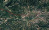
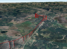
Here’s the ADS-B track superimposed on the landscape:

N740TS - overhead view

N740TS - orthogonal view
 
I'm sorry, but this seems like another case of poor ADM, even if the pilot had flown that route before. Planning to arrive at a mountain airport 2 1/2 hours after sunset on a relatively moonless night that doesn't have an instrument approach doesn't make sense. From the ADSB track data it appears the pilot flew direct at 9500 which at least provided some terrain clearance until about time to start a descent but mountain flying, in the dark, single engine? It looks like a classic case of get-there-itis.
 
Last edited:
Low (down to 150' AGL), slow, then turning, gently climbing and finally adding full power, all on autopilot! Don't know too much about the Cirrus training program, but regardless of what it recommends, my preference would be hand flying rather than pushing buttons in that scenario. 150' AGL without runway lights in sight is a death wish.
 
Back
Top