flyersfan31
Touchdown! Greaser!
- Joined
- Mar 31, 2006
- Messages
- 14,269
- Display Name
Display name:
Freiburgfan31
Just how far do you have to dig to get the absolutely final word on TFR's?!!
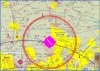
Willow Grove NAS (KNXX) class D airspace is very close to the end of rwy 6 @ KLOM, so we're accustomed to treating that airspace as a wall not to be crossed on departures and in the pattern.
There is a big airshow at KNXX this weekend, with the inevitable TFR. AS PUBLISHED, the TFR is centered on a 5nm radius around the Yardley 264 radial @ 11.5mi.
Well, since I hope take a few flights over the next couple days, I figured I'd check and double check the TFR. I fired up Golden Eagle and used the ruler to place a waypoint at the TFR center per the published location. I expected it to be centered on the airport itself, and figured I was engaging in a VERY academic exercise. Well, I scratched my head, because doing so put the center of the TFR a bit north of KNXX. Hmm, well let's set a waypoint with the TFR's Lat/Lon coordinates as published. Guess what? That waypoint was centered on the airport. I wondered if the published location should have read "ARD 254 radial?" Guess what -- 11.5mi on the 254 is directly over the airport.
I'm going to check with FSS to see how they describe it to me - they may just say "there's a 5 mi TFR over KNXX" and leave it at that. Obviously, the best solution is to maintain a wide berth from any TFR (treat 'em like a thunderstorm) but in some situations, like this one where the TFR is so close to our pattern, you'd really like the published info to be correct. Wouldn't you????????

")