

flyingcheesehead
Taxi to Parking
- Joined
- Feb 23, 2005
- Messages
- 28,184
- Location
- UQACY, WI
- Display Name
- iMooniac
- Home Airfield
- KUES/KMKE
Well, I figured out what to do with myself during my layover in Tampa. 
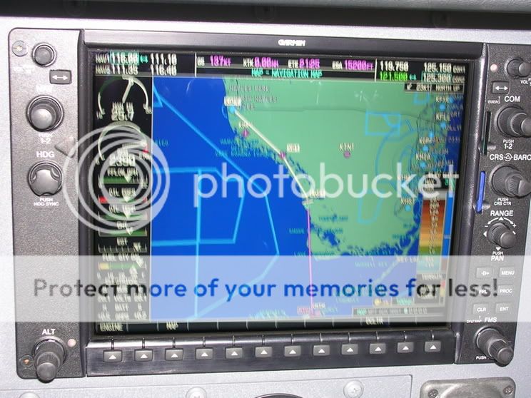
I went to North Tampa Aero Park (X39) and rented a 2005 C182 with a G1000 glass cockpit. The plane was superbly equipped. I think it had every option except air conditioning. Air bags, G1000, Traffic, Terrain, Stormscope, weather datalink, XM radio... *drool* (we need a smilie for that.)

This 182 was just a tad bit different from the 1971 version that I usually fly. It's fuel-injected, but unlike other fuel-injected airplanes I've flown, there was no control for alternate air. The starting procedure is also a bit different, both due to the fuel injection and also the G1000. You start by holding the Standby Battery switch down to "test" for twenty seconds to make sure the light says lit. Then, you switch it to "Arm" which powers up the G1000 PFD.
After a short power-up cycle, you check to be sure the standby battery annunciator as well as a couple of others are on, the standby battery shows discharge, and the main electrical bus shows 0 volts, you turn on the Master switch. Then, on to a normal fuel-injected engine start: Fuel pump on, Throttle 1/4", Mixture in and out, fuel pump off, start, mixture rich. When the engine has started and is running well (the engine instruments are on the PFD when it's the only operating display), you turn on the Avionics master, which powers on the G1000 MFD and the rest of the avionics.
I did a 1.1 hour checkout including a short hop to Brooksville (KBKV) for a practice ILS and a few landings. They have May turbulence down here in January! My landings were not great. I didn't realize how used to my own club 182 I am, this one seemed quite different and the first couple of landings were of the "get down, dance around, play with power, put 'er down" variety. Blech. The first landing attempt back at X39 I decided to go around and didn't even do so hot with that. Climb it, CLEAN it, cool it, and call it. Next time around was pretty decent, however.
After the checkout, it was time for some fun. I got the plane topped off, called for a briefing, and reviewed the Tampa TAC and Miami sectional to finalize my route.

I launched off 32, climbed to 2500, called TPA approach (a very nice class B to fly around), and flew west to the shoreline and then south to Albert Whitted (KSPG). It's in the Sporty's Private Pilot video, they tried to close it recently, and it's right on the water like Meigs was. So, I had to land there. A left downwind for 36 puts you right over downtown with quite a few buildings sticking up seemingly close to pattern altitude (probably why the normal pattern is right traffic). Turning base you start out over the water, and final puts over water right to the last minute. I landed, taxied back, and took off again, with a right-hand departure over the water this time.

Next I headed south to Venice (KVNC), first at 1,000 feet to stay below the Class B shelf, then 2,500 once I got cleared into the Bravo (I did have to remind the controller to say the magic words for me). I overflew Sarasota and continued down the shoreline. Since I missed y'all at the lunch at Sharky's a couple of weeks ago, I had to try it. So, that was my lunch stop. The Clam Chowder there is excellent!


After takeoff, I headed south along the shoreline. When I got near Fort Meyers, I called for flight following again. Not too far south of Fort Meyers, however, I got "radar services terminated, squawk VFR, frequency change approved." I queried the controller as to who I could get flight following from, and he responded that I'd have to climb to at least 5,000 feet and contact Miami Center. I decided to just stay low and keep quiet for a while.
After passing Naples, it starts to be quite sparsely populated; after Everglades there is nothing. The rest of the way to the end of the Florida peninsula is devoid of civilization, as it consists of the Big Cypress National Preserve and Everglades National Park. It occurred to me that having an engine failure in this area would be almost as bad as over water! Thanks to the G1000 though, I had plenty of information about how the engine was running and it appeared to be healthy as could be.

I'd put a waypoint into the G1000 at the mouth of the Lost Man River, right on the Blue 9 airway (NDB airway... New one to me!), and shortly before I arrived there I began climbing. When I arrived at my waypoint (which I named "Lost" in honor of the river - I hope they appreciate my sense of humor!), I turned south towards the Marathon NDB, continued my climb to 9500 feet, said a little prayer to the engine gods, and headed out over the water.

After all my apprehension about all that water, the crossing really seemed quick. I had to descend to 5500 due to a cloud layer ahead, but I leveled out at 5500 and only a minute or so later I was already over Marathon Key and turning west. The sun was close to setting and the small cloud layer provided some interesting shots.

After a few minutes, Miami Center handed me off to Key West Approach, which is actually a military facility (Key West NAS). When I checked in, they gave me the setting "Navy altimeter 30.26." Key West International is just 3-4 miles past Key West NAS. When I was almost over Key West NAS, they told me to stay south of the shore and not overfly the field. I replied that I was almost over it, but turning to the south. Key West NAS is very easy to spot, it has three runways, one of which is roughly parallel to US 1 (the bridge that goes through the Keys). Key West International is harder to spot, and I didn't spot it until about 6 miles out.
I entered a right downwind for runway 9 at Key West International and turn base to follow a Beechjet on final. There was a pretty stiff wind, 16 knots direct crosswind (still much better than the 19G25 it had been when I originally left X39). My first landing attempt wasn't very pretty, so I went around for another try. The second time, I managed to get it down okay and keep it planted firmly on the runway.

We ate dinner, and I bought a T-shirt (yep, BTDT got the T-shirt) that says "I went all the way! Southernmost airport in the USA. Key West." (Actually, it should say southernmost in the *continental* US, but oh well.)
After calling several friends (I wasn't gloating... I really wish I could have more of these adventures with my friends!) I called Flight Service for an updated briefing and to file a flight plan. Normally I don't file VFR flight plans because I somehow manage to forget to close them every time, but I figured with a night flight over so much water and barren land I'd take every precaution possible.
I filed KEYW -D> MTH Blue 9 DEEDS V35 MURDO -D> X39. The briefer had never heard of the NDB airway, and I told him I'd never seen one before either, but he said "Well, the computer took it!" so I was off.
Key West Tower was closed, so after takeoff I turned toward the west and circled the western half of the island to stay out of Key West NAS airspace and call them up for flight following. They were just about to close, but stayed with me until I was a bit over 7,000 feet and about 10 miles from Marathon before handing me off to Miami Center.
Upon reaching Marathon I turned north onto Blue 9 and climbed to 10,500 feet. The clouds had drifted away and the night was very clear. The glow of Miami could easily be seen 70 miles away to the right, and Key West could still be seen 50 miles back and to the left. Naples was just a subdued glow off the left of the nose.
As we approached the peninsula of the Florida mainland, the shallower waters and smaller waves revealed a beautiful reflection of the moon. The darkness of the Everglades and the distant, glowing cities contrasted with the clear, starry sky. The skies were fairly quiet tonight, and the same controller worked me on three frequencies for about an hour and a half. The constant hum of the engine and his occasional transmission to a distant airliner were the only sounds.
I had been poking the buttons on the G1000 from time to time, trying to learn as much as possible before I had to stop flying this excellent bird, and I saved the best for last: XM Radio. I had been focusing on the aviation features, but I had to use the XM at least once. I turned it on, skipped around to find a good channel, and sat back to enjoy. The music automatically cut out every time air traffic control transmitted something, but after a few minutes Miami Center quieted down. I couldn't help the grin that crossed my face as glow of the city lights bathed the underside of the wings while the soothing voice of Natalie Cole filled my ears.

All too soon, she was interrupted by the Miami Center controller I'd been talking to for about the last hour and a half finally handing me off to Tampa Approach. They cleared me into their airspace "at or below 3,000" and I was still at 10,500 feet. Time to come down! I set the autopilot for a 1,000 fpm descent to 3,000 feet and checked the MFD to make sure I'd make it in time. I calculated that I'd be under the 6,000 foot outer shelf of the Tampa airspace by the time I got there, and I'd be at 3,000 feet by the time I actually entered their airspace.
Down low now, the lights seemed to be moving a lot faster. Tampa instructed me to descend and maintain 1,600 feet, which made the lights really scream past. That reminded me that I needed to activate the lights at X39, and Tampa Approach bade me good night at just the right time. I clicked the lights on, or so I thought. I still didn't see an airport in the right spot, and after cross-referencing with the map on the MFD several times, I decided to try the lights again.
Suddenly, out of the darkness, a patch straight ahead and very close by became a glittering landscape of red, white, blue, and green lights. I circled around the pattern once and made one of my better landings of the day to finish the flight. I shut down, put the bird to bed, dropped off the keys, and stood near the runway for a moment to enjoy the clear, still night air.
Flights like that... That's why we fly.
BTW, for you gadget junkies, I'll be posting more on the G1000, incl. better MFD pic, later.
I went to North Tampa Aero Park (X39) and rented a 2005 C182 with a G1000 glass cockpit.
The plane was superbly equipped. I think it had every option except air conditioning. Air bags, G1000, Traffic, Terrain, Stormscope, weather datalink, XM radio... *drool* (we need a smilie for that.)
This 182 was just a tad bit different from the 1971 version that I usually fly. It's fuel-injected, but unlike other fuel-injected airplanes I've flown, there was no control for alternate air. The starting procedure is also a bit different, both due to the fuel injection and also the G1000. You start by holding the Standby Battery switch down to "test" for twenty seconds to make sure the light says lit. Then, you switch it to "Arm" which powers up the G1000 PFD.
After a short power-up cycle, you check to be sure the standby battery annunciator as well as a couple of others are on, the standby battery shows discharge, and the main electrical bus shows 0 volts, you turn on the Master switch. Then, on to a normal fuel-injected engine start: Fuel pump on, Throttle 1/4", Mixture in and out, fuel pump off, start, mixture rich. When the engine has started and is running well (the engine instruments are on the PFD when it's the only operating display), you turn on the Avionics master, which powers on the G1000 MFD and the rest of the avionics.
I did a 1.1 hour checkout including a short hop to Brooksville (KBKV) for a practice ILS and a few landings. They have May turbulence down here in January!
My landings were not great. I didn't realize how used to my own club 182 I am, this one seemed quite different and the first couple of landings were of the "get down, dance around, play with power, put 'er down" variety. Blech. The first landing attempt back at X39 I decided to go around and didn't even do so hot with that. Climb it, CLEAN it, cool it, and call it. Next time around was pretty decent, however.After the checkout, it was time for some fun. I got the plane topped off, called for a briefing, and reviewed the Tampa TAC and Miami sectional to finalize my route.
I launched off 32, climbed to 2500, called TPA approach (a very nice class B to fly around), and flew west to the shoreline and then south to Albert Whitted (KSPG). It's in the Sporty's Private Pilot video, they tried to close it recently, and it's right on the water like Meigs was. So, I had to land there. A left downwind for 36 puts you right over downtown with quite a few buildings sticking up seemingly close to pattern altitude (probably why the normal pattern is right traffic). Turning base you start out over the water, and final puts over water right to the last minute. I landed, taxied back, and took off again, with a right-hand departure over the water this time.
Next I headed south to Venice (KVNC), first at 1,000 feet to stay below the Class B shelf, then 2,500 once I got cleared into the Bravo (I did have to remind the controller to say the magic words for me). I overflew Sarasota and continued down the shoreline. Since I missed y'all at the lunch at Sharky's a couple of weeks ago, I had to try it. So, that was my lunch stop. The Clam Chowder there is excellent!
After takeoff, I headed south along the shoreline. When I got near Fort Meyers, I called for flight following again. Not too far south of Fort Meyers, however, I got "radar services terminated, squawk VFR, frequency change approved." I queried the controller as to who I could get flight following from, and he responded that I'd have to climb to at least 5,000 feet and contact Miami Center. I decided to just stay low and keep quiet for a while.
After passing Naples, it starts to be quite sparsely populated; after Everglades there is nothing. The rest of the way to the end of the Florida peninsula is devoid of civilization, as it consists of the Big Cypress National Preserve and Everglades National Park. It occurred to me that having an engine failure in this area would be almost as bad as over water! Thanks to the G1000 though, I had plenty of information about how the engine was running and it appeared to be healthy as could be.
I'd put a waypoint into the G1000 at the mouth of the Lost Man River, right on the Blue 9 airway (NDB airway... New one to me!), and shortly before I arrived there I began climbing. When I arrived at my waypoint (which I named "Lost" in honor of the river - I hope they appreciate my sense of humor!), I turned south towards the Marathon NDB, continued my climb to 9500 feet, said a little prayer to the engine gods, and headed out over the water.
After all my apprehension about all that water, the crossing really seemed quick. I had to descend to 5500 due to a cloud layer ahead, but I leveled out at 5500 and only a minute or so later I was already over Marathon Key and turning west. The sun was close to setting and the small cloud layer provided some interesting shots.
After a few minutes, Miami Center handed me off to Key West Approach, which is actually a military facility (Key West NAS). When I checked in, they gave me the setting "Navy altimeter 30.26." Key West International is just 3-4 miles past Key West NAS. When I was almost over Key West NAS, they told me to stay south of the shore and not overfly the field. I replied that I was almost over it, but turning to the south. Key West NAS is very easy to spot, it has three runways, one of which is roughly parallel to US 1 (the bridge that goes through the Keys). Key West International is harder to spot, and I didn't spot it until about 6 miles out.
I entered a right downwind for runway 9 at Key West International and turn base to follow a Beechjet on final. There was a pretty stiff wind, 16 knots direct crosswind (still much better than the 19G25 it had been when I originally left X39). My first landing attempt wasn't very pretty, so I went around for another try. The second time, I managed to get it down okay and keep it planted firmly on the runway.
We ate dinner, and I bought a T-shirt (yep, BTDT got the T-shirt) that says "I went all the way! Southernmost airport in the USA. Key West." (Actually, it should say southernmost in the *continental* US, but oh well.)
After calling several friends (I wasn't gloating... I really wish I could have more of these adventures with my friends!) I called Flight Service for an updated briefing and to file a flight plan. Normally I don't file VFR flight plans because I somehow manage to forget to close them every time, but I figured with a night flight over so much water and barren land I'd take every precaution possible.
I filed KEYW -D> MTH Blue 9 DEEDS V35 MURDO -D> X39. The briefer had never heard of the NDB airway, and I told him I'd never seen one before either, but he said "Well, the computer took it!" so I was off.
Key West Tower was closed, so after takeoff I turned toward the west and circled the western half of the island to stay out of Key West NAS airspace and call them up for flight following. They were just about to close, but stayed with me until I was a bit over 7,000 feet and about 10 miles from Marathon before handing me off to Miami Center.
Upon reaching Marathon I turned north onto Blue 9 and climbed to 10,500 feet. The clouds had drifted away and the night was very clear. The glow of Miami could easily be seen 70 miles away to the right, and Key West could still be seen 50 miles back and to the left. Naples was just a subdued glow off the left of the nose.
As we approached the peninsula of the Florida mainland, the shallower waters and smaller waves revealed a beautiful reflection of the moon. The darkness of the Everglades and the distant, glowing cities contrasted with the clear, starry sky. The skies were fairly quiet tonight, and the same controller worked me on three frequencies for about an hour and a half. The constant hum of the engine and his occasional transmission to a distant airliner were the only sounds.
I had been poking the buttons on the G1000 from time to time, trying to learn as much as possible before I had to stop flying this excellent bird, and I saved the best for last: XM Radio. I had been focusing on the aviation features, but I had to use the XM at least once. I turned it on, skipped around to find a good channel, and sat back to enjoy. The music automatically cut out every time air traffic control transmitted something, but after a few minutes Miami Center quieted down. I couldn't help the grin that crossed my face as glow of the city lights bathed the underside of the wings while the soothing voice of Natalie Cole filled my ears.
All too soon, she was interrupted by the Miami Center controller I'd been talking to for about the last hour and a half finally handing me off to Tampa Approach. They cleared me into their airspace "at or below 3,000" and I was still at 10,500 feet. Time to come down! I set the autopilot for a 1,000 fpm descent to 3,000 feet and checked the MFD to make sure I'd make it in time. I calculated that I'd be under the 6,000 foot outer shelf of the Tampa airspace by the time I got there, and I'd be at 3,000 feet by the time I actually entered their airspace.
Down low now, the lights seemed to be moving a lot faster. Tampa instructed me to descend and maintain 1,600 feet, which made the lights really scream past. That reminded me that I needed to activate the lights at X39, and Tampa Approach bade me good night at just the right time. I clicked the lights on, or so I thought. I still didn't see an airport in the right spot, and after cross-referencing with the map on the MFD several times, I decided to try the lights again.
Suddenly, out of the darkness, a patch straight ahead and very close by became a glittering landscape of red, white, blue, and green lights. I circled around the pattern once and made one of my better landings of the day to finish the flight. I shut down, put the bird to bed, dropped off the keys, and stood near the runway for a moment to enjoy the clear, still night air.
Flights like that... That's why we fly.
BTW, for you gadget junkies, I'll be posting more on the G1000, incl. better MFD pic, later.
Last edited:


 smiley, I think they need to add a :green with envy: one as well

