Unbeliever
Pre-takeoff checklist
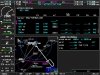
So take this approach:
KRAL VOR or GPS-B
My instructor brought this up as an oddity in the fact that Jepp and NACO list the final stepdown fix (ARCLY) differently. In NACO, the minimums strip lists a lower minimum under the "Dual VOR minima". Under Jepp, it's listed under "ARCLY minima." You get an extra 700 feet The instructor brought it up as a lesson about differences between Jepp and NACO (I think) and we speculated as to why they might be different. It was also chosen as another local approach with a procedure turn that I hadn't done yet.
I chose to fly it as a GPS approach (430W), and fortunately, we were given the full procedure unprompted when were cleared for the VFR practice approach before we even got to PDZ. Even if I'm flying a GPS approach, if it's an overlay, I've been trying to make a habit of setting up and identifying the underlying VORs just in case. I'm glad I did that this time because I think we figured out why Jepp is different from NACO on this one.
This is my (hopefully) second or third to last lesson before the checkride, so my instructor has been keeping his mouth shut and sitting on his hands and letting me screw up, if needed. So I do the HILOPT, and turn inbound and as soon as I pass MIRAM, I got thrown for a loop. On the GPS navigator, ARCLY doesn't show up. It's just a segment from MIRAM to RAL.
So my thought process was interesting. "No ARCLY! How can I identify ARCLY?" I say out loud "Hmm, 2 miles in the plan view from RAL to ARCLY, watch for 2 miles." Then I think, "No, the 2 isn't in a D, I can't use it." think, think, think.. tick tock. Then I realize and say out loud "Dual VOR minima!" There's a reason why I back up the GPS with VORs. By force of habit, I had already "twisted" the NAV tuned to PDZ to 074 when I crossed MIRAM.
This was mainly a self-debrief story, and an example to use everything at your disposal. But two questions.
1) Why isn't ARCLY in the GPS database? It's a clear stepdown in the procedure. Is that why Jepp lists ARCLY differently?
2) We're allowed to twist/flip/twist to identify an intersection normally, why not on this approach? We have 80 seconds at 90 knots to the VOR from ARCLY.
Oh, hmmm..... I just thought of a third question for all of us nit-picky types. It would make a great oral exam question.
3) I wound up flying this as a combination GPS/VOR approach. Since we're not allowed to add our own waypoints for approach mode on GPS approaches, and I used the VOR to identify ARCLY, did I bust minimums by flying a GPS approach and descending below 2340 to 1660? Should I have switched to VOR/VOR and not GPS/VOR as I wound up flying it?
I forgot to ask my instructor if he knew this would happen, and if it was a deliberate lesson.
--Carlos V.