Sorta Aviation: The evils of Google Maps /earth.....

archerdriver

Pre-takeoff checklist
Joined
Jul 9, 2013
Messages
117
Location
NY
Display Name

Display name:
Archerdriver
Most . Efficient. Time. Suck. Ever.

40.596940, -97.568668 - Airport in Nebraska

upload_2016-9-22_11-42-44.png


34.921571, -118.528417 - NW of Mojave Airport / Spaceport

WTF IS That??
upload_2016-9-22_9-19-47.png


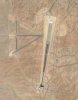
Hella private strip - looks like 1 mile +/- - and look at the fuel tank! (bottom center)

upload_2016-9-22_9-20-15.png
38.325539, -116.274097


Last edited:
I don't think those are airstrips. Looks like they have big radio antennas on them. I know there are some microwave telcom relays in the area (near Gorman), though those are much too big for microwave.

I'm planning a flight down there tomorrow, past GMN, and that isn't too far out of they way. Maybe I'll peek if it isn't too windy. Forecast is for strong northerly wind, so a south slope of a 6000 foot mountain may not be a good place.

There are A TON of uncharted private strips all over rural California. Some of them quite nice.
 
The bottom one could be a drone testing area. There are a few out in that area.
 
The 1st and second picture seem to be the same pic (Mojave). I think its some kind of radar range test facility.
 
corrected 1st pix.

2nd site - never seen radar / radio / microwave stations that needed an acre or three of concrete in front of them, but what do I know..
 
corrected 1st pix.

2nd site - never seen radar / radio / microwave stations that needed an acre or three of concrete in front of them, but what do I know..

Those are on a fairly steep slope with lots of alluvial fans and other strong erosion indicators around.

And it's northwest of Palmdale, not Mojave.

There is indeed a substantial UAV program through that area.
 
BlackTower.jpg I used to fly near this one, interesting place.
 
There's another odd one that at first blush looks like a runway, but isn't. It's at 34.82N/117.30W, about 15 miles north-northeast of KVCV.
 

Attachments

  • desert.jpg
    desert.jpg
    36.5 KB · Views: 36
And now the Men in Black visit every one of us who has seen the pictures and says " If you would look right here for a moment..."

Thanks so much for that.
 
There's another odd one that at first blush looks like a runway, but isn't. It's at 34.82N/117.30W, about 15 miles north-northeast of KVCV.
That one kinda-sorta looks like a rocket booster or jet engine test stand.

And Lockheed has land nearby.
 
I am thinking that some of those might be radar test stands (?) based on some books I have read on formerly classified stealth planes etc.

Found this interesting looking plane at Van Nuys APT - NW corner. Homebuilt ER-2/ U2? Badass motor-glider?

Capture.JPG
 
Looks like a U2 to me.

I wonder if some of the sites in the OP's post are laser test areas? :dunno:
 
Back
Top