Mike, thank you for advice. I keep hearing these routes (Track, Linden) and saw it on NYC Heli map. Seem easy enough. Do they actually tell you to fly these routes?
You won't likely be assigned them unless you request them, since the controller may not know you're familiar with the routes.
For your flight, the most direct route, here's how it might go:
You (on Newark 127.85): "Newark Tower, MEANEE1 off of Linden, 800ft"
EWR: "MEANEE1, Squawk 0305, say request"
You: "0305 MEANEE1, Request Linden route, overhead Newark, Governor's Island, handoff Kennedy for Track routing eastbound"
EWR: "MEANEE1, Radar contact 800ft one mile east of Linden, cleared into the Class Bravo airspace, climb and maintain 1500. Proceed north on the Linden route then overhead the runway 22 numbers. Altimeter 29.87"
You: "29.97, cleared in, climb and maintain 1500ft Linden route overhead 22 numbers, MEANEE1"
After flying over EWR, you'll head direct Governor's Island, then likely be told to contact Kennedy:
EWR: "MEANEE1 Proceed direct Governor's Island, contact Kennedy Tower on (119.1/123.9/125.25)"
You: "Direct Governor's, switching to Kennedy 119.1 MEANEE1"
You (On JFK 119.1): "Kennedy Tower, MEANEE1 level 1500, Track routing eastbound to Farmingdale"
JFK: "MEANEE1, Proceed direct Ridgewood Reservoir then join the Tracks eastbound. Altimeter 29.88"
You: "29.88, direct Ridgewood, tracks eastbound, MEANEE1"
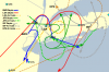
Now, just follow the railroad tracks after passing the reservoir. At some point on a second radio if you have one, pick up the ATIS at FRG on 126.65. At some point once you pass the 70|SFC part of the Class B at the JFK 8nm ring, you will probably be dropped by JFK:
JFK: "MEANEE1, descend to 1400ft or below, radar service terminated, squawk VFR"
You: "Squawk VFR, 1400ft or below, MEANEE1"
That's a good time to call up FRG:
You (on FRG 118.8): "Republic Tower, MEANEE1, one mile north of Nassau Coliseum, 1400ft, inbound with (ATIS)"
FRG: "MEANEE1, Republic, join the left downwind for Runway 32, report joining the downwind"
Business as usual from then on out! It's a little intimidating the first time but quickly becomes second nature.
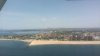

 Wonder what they thought of that. Seeing nothing but sky to one side, nothing but ground on the other, and the whole world tilted 45 degrees has got to be an intimidating view for a non-pilot.
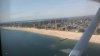
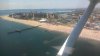
 Of course, if the beaches are crowded, from there you will still technically be ditching if you have trouble- when the beaches are crowded, so are the beach roads. Only time I did that route was in mid-winter, so the beach was available all the way to Montauk.
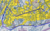
 .
.