Search for my name and look for a video I did on the bay tour a while back.
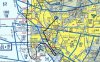
If you're coming down from LA you'll be flying down the coastline across the departure from CRQ. At some point before Del Mar you'll wanna be down below 1800' to stay under the Miramar Bravo. You'll then want to continue to descend as you get to La Jolla, here's why. Somewhere around the tip of La Jolla (a couple miles north of Crystal Pier) you'll wanna call Lindbergh Tower (118.3) and request a "Coastal Transition". The clearance you will get is "offshore at or below 500', report OB pier." When you pass OB pier you check in and if North Island is operating they'll tell you to contact them.
When you contact North Island Tower (135.1) you'll tell them where you are, and that you'd like to round the end of point loma for a "Channel Transition" or Bay Tour. Most of the time they will tell you to advise when rounding point loma and approve at 700', though I have been denied recently because they had a lot of military activity going on. They are quite helpful and will try to fit you in though. They wont always give you this disclaimer, but consider it a rule "do not overfly military ships or facilities" basically stay over the water, not the docked ships.
I usually fly down that way over the bridge then turn around over the south bay. They generally will ask your intentions, just let them know you'll be doing a 180 and coming back. Most of the time I will ask for the Delta transition on the way back north, this takes you directly over the downtown buildings and Lindbergh field. Let NI tower know that you'll be doing this and they will hand you off as soon as you report your 180. Switch back to 118.3 and call SAN again, let them know you want a delta transition and they will usually clear you at 1000 or 1500'. The route is along taxiway Delta, which is the huge diagonal one. It also happens to put you pretty much on a direct course from the San Diego end of the coronado bridge to the Mission Bay VOR.
EDIT: Found the video for you. Pretty much everything you need should be here.