Rotting VORs revisited

bobmrg

En-Route
Gone West
Joined
Aug 13, 2007
Messages
3,183
Display Name

Display name:
Bob Gardner
Back at the end of February there were some posts about the status of the VOR system. We had known about the FAA's Minimum Operating Network Plan since late 2014, but why mess up a good story"

http://tinyurl.com/n9v3wz2

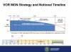
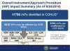
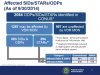
This URL will take you to the current situation: VORs are being thinned out, but they are not going away. Those that remain will be enhanced, with their Service Volumes extended to 77nm at 5000 feet; VOR coverage nationwide will be seamless at 5000 feet. Many more Q and T routes will be established.

All this courtesy of Bruce Williams.


Bob Gardner
 
That's quite interesting, thank you for posting bob. I've often thought that the 40 nm SSV below 14,500' for an H class VOR to be unrealistic, I've never seen an H class VOR that wouldn't give you a navigable signal out to at least 100 miles at 5000' agl unless it was behind a mountain or down at the bottom of a gorge.
 
And see, I thought climbing to 3k AGL to get a VOR was annoying.....
 
Thank you for the link, Bob, an interesting read for sure.

Now I am not second-guessing my large ($4k) investment into an IFR GPS. Even if many VORs go away, I can still use a T-route to get to my intended destination and shoot a VNAV approach. :)
 
Thanks for posting - that is fascinating.

DME-only facilities will be a weird concept - and one that won't apply to me anyway.

The key slides from my perspective:

attachment.php


attachment.php


attachment.php
 

Attachments

  • VOR MON Timeline.jpg
    VOR MON Timeline.jpg
    209.1 KB · Views: 215
  • IAPs affected by VOR MON.jpg
    IAPs affected by VOR MON.jpg
    341.5 KB · Views: 214
  • STAR DP Affected by VOR MON.jpg
    STAR DP Affected by VOR MON.jpg
    338.4 KB · Views: 214
Is there a list of the VORs up for decommissioning ?

Nothing that has been released to the public. Search for "minimum operating network" and you will find some not-too-specific graphics.

Bob
 
Looks like it has started. Two VORs have dropped off the map in the last week.

HVQ
BWG

Both are NOTAM'd with unusable radials, vector, and jet routes until permanent.

PBF is getting flaky with lots of MX downtimes.
 
Even after the physical VORs go away, will they remain in the databases as three-letter identifiers with associated lat/lon, to be used as GPS waypoints?
 
Even after the physical VORs go away, will they remain in the databases as three-letter identifiers with associated lat/lon, to be used as GPS waypoints?

They will be renamed with the standard GPS waypoint naming protocol. For instance, a decommissioned VOR, Lake Henry, LHY, in my area, became a GPS waypoint identified as LAAYK. Bradley Int'ls became a T route waypoint NELIE.

There's a discussion out there regarding three letter identification and DME fuctionality. My relative in the FAA was reassigned to DC this past year as part of a team researching the implementation of the whole switchover. It's an amazingly complex situation.
 
Last edited:
Back
Top