Lawreston
En-Route
. . . . with my truck, but it did $3400.00 damage.
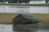
Photo #3: was after the incident photography. Note the right door post while vehicle is stopped.
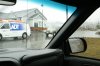
Photo #2: shows what shouldn't have been in the travel lane. Estimated weight is between 400 - 500 pounds. My right rocker panel from front to back is trashed; the front of the body is pushed in 3.5" from matching the rear of the cab.
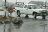
Photo #1: That's one big sucker(after it had been removed from the street). Police say it's the shopping center's responsibility to keep the avenues free from any traffic hazard.
HR
Photo #3: was after the incident photography. Note the right door post while vehicle is stopped.
Photo #2: shows what shouldn't have been in the travel lane. Estimated weight is between 400 - 500 pounds. My right rocker panel from front to back is trashed; the front of the body is pushed in 3.5" from matching the rear of the cab.
Photo #1: That's one big sucker(after it had been removed from the street). Police say it's the shopping center's responsibility to keep the avenues free from any traffic hazard.
HR
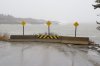
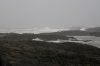
 . Thanks for the photos of Land's End, I've been there lots more than once. I'll send these photos on to my parents who will be interested.