You are using an out of date browser. It may not display this or other websites correctly.
You should upgrade or use an alternative browser.
You should upgrade or use an alternative browser.
question about info on VRF sectional
- Thread starter Badger
- Start date
FlyingIsGood
Pre-takeoff checklist
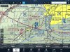
See the light blue arrows going SSE? Those are the traffic corridor altitudes.
THIS.
And I think you're looking at the Kansas City TAC, not the standard sectional.
Badger
Pattern Altitude
- Joined
- Dec 29, 2011
- Messages
- 2,137
- Display Name
Display name:
Badger
See the light blue arrows going SSE? Those are the traffic corridor altitudes.
LOL, I didn't even see them.
So the 7-15k indications really doesn't have anything to do with KIDX (just location of the printing)
EdFred
Taxi to Parking
THIS.
And I think you're looking at the Kansas City TAC, not the standard sectional.
Well he is looking at a VRF sectional.
") and yeah, I only see those on TACs
and yeah, I only see those on TACsEdFred
Taxi to Parking
LOL, I didn't even see them.
So the 7-15k indications really doesn't have anything to do with KIDX (just location of the printing)
Nope. Nothing to do with IXD. Look at some other TACs and you will see a lot of them pointing to and from the Bravos.
Badger
Pattern Altitude
- Joined
- Dec 29, 2011
- Messages
- 2,137
- Display Name
Display name:
Badger
THIS.
And I think you're looking at the Kansas City TAC, not the standard sectional.
It's a screen shot from ForeFlight, so you are correct, when I zoomed in, it went to the TAC. thanks
roncachamp
Final Approach
at KIXD there is a 7,000-15,000 notation. KIXD looks like normal class D.
What does this 7,000 - 15,000 mean?
It's an IFR Departure Route, associated with the light blue arrowheads to the right. Note that it appears on the Terminal Area Chart, not on the sectional. Has nothing to do with KIXD
Matthew
Touchdown! Greaser!
Pan to the left just a little, and look to the west, lear LWC. You'll see the arrival route.
edit: This is one area where a paper chart is better than the zoomed in electronic version - you can see more and get it all in context.
edit: This is one area where a paper chart is better than the zoomed in electronic version - you can see more and get it all in context.
Last edited: