jesse
Touchdown! Greaser!
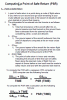
How would you name a function on a mobile application that helps you determine the point in which it's faster to continue to your destination versus turn around? For example, crossing a major lake.
What would the parameters of that function be?
I'm trying to think of the best way to name and build this into an app I'm making. I know some of you have some excel spreadsheets for this stuff.
I'm not really convinced that "point of no return" is the best name. "point of no return" to me means the point in which you cannot return to your departure airport because you no longer have the fuel remaining to do so.
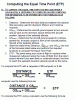