Plane down Western AR.

PA-46 M500 The weather was a bit nasty in north Louisiana/Arkansas last evening.

The flight profile looked routine until, what I presume would be, the anticipated TOD. Once descent began the aircraft started at around -1,100 fpm but that decayed, increased, then decayed precipitously. This all happened on the same heading until the rate exceeded -5,000 fpm in a RH turn. I wonder if they flew into convection on descent, autopilot disengaged, and entered the graveyard spiral. RIP


The weather near the crash site was reportedly very good, almost clear. It was dark out.
He was pretty high, could hypoxia contribute? Seems like something to consider. I didn’t hear any mention of a distress call.
 
They would have just begun to encounter some light (maybe light-mod) precip that was part of but well out ahead of a mesoscale convective system to the southwest. Radar data indicate that the aircraft and the eastward propagation of the precip coincided to arrive almost exactly simultaneously at the point of the descent and subsequent crash.

There was an AIRMET tango for moderate turbulence from FL210 to FL410, the polygon for which began just a few miles beyond where the descent was initiated. The turbulence forecast in the area and time indicated a decent possibility of widespread light to moderate. There was a PIREP in the general vicinity for light to moderate chop at FL240 about 50 minutes prior. Several other moderate turbulence PIREPS in the wider area in the mid 20s to 30s.

The freezing level would have been about 13,000’. An AIRMET for icing associated with the precip of that MCS from the freezing level to FL240 went up in that area about two hours after the crash
 
I saw a photo of the sky not far from the accident site near that time.....pretty much CAVU.
 
IMG_2941.jpeg

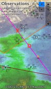
According to ADS-B data, “D” is where the top of descent occurred, X is where the loss of control and crash occurred. The echoes are not strong, but it wasn’t CAVU.
 
According to ADS-B data, “D” is where the top of descent occurred, X is where the loss of control and crash occurred. The echoes are not strong, but it wasn’t CAVU.
I determined the same locations/Wx imaging as you but photos and observations from a couple of users on BT report near CAVU. That caught me by surprise.
 
I determined the same locations/Wx imaging as you but photos and observations from a couple of users on BT report near CAVU. That caught me by surprise.
Yeah, it was just the very leading edge of a 200 mile deep MCS that formed along the quasi-stationary front. Go 10 miles in any downwind direction and it would have been CAVU or high clouds at worst.

I’m just showing the data that show there was something there and the changing conditions happened to coincide with the crash area. There’s a plethora of interactions that this weather could or could not have induced, but whether it’s causal/contributing or not is way too soon to know.
 
Final Report for N241PM

The left horizontal stabilizer, vertical stabilizer, rudder, elevator, right aileron, right flap, and the outboard portion of the right wing were not located at the accident site and likely separated as a result of the in-flight breakup.

The pilot would not have had out-of-cockpit visual reference for the majority of the end of flight. The investigation considered the possibility that the pilot experienced spatial disorientation after taking control of the airplane from the autopilot during the descent.

Analysis of weather sounding data also indicated strong vertical wind shear between 13,000 ft and 16,000 ft and a high possibility of moderate or greater turbulence within those altitudes. Accordingly, the investigation also considered the possibility that the airspeed exceedances during the descent, combined with the moderate and greater turbulence forecast for the area just below the airplane’s flight path, resulted in structural damage to the airplane that rendered it uncontrollable.

NTSB Probable Cause : The pilot’s exceedance of the airplane’s design limitations, which resulted in an in-flight breakup.

 
2003 year of manufacture, relatively low hours. Hard to fly the plane when serious parts of the airframe are missing. ATC cleared the aircraft from FL 200 all the way down to 6000’. That seems to imply he was high on a desirable profile to landing. Of course he could ask for vectors to get down, do a 360, whatever. It’s also semi rural AR, so maybe clear of traffic below.

A more gradual descent may of been less likely to entice the pilot to allow himself to get into the overspeed condition . I’m just throwing out a little something to break a similar accident chain earlier. Of course much falls to piloting 101, maybe 202. One should heed airframe speed limitations, especially in or near potential turbulence.
TOD was about 115nm from the destination. From FL280 assuming a constant 225kt groundspeed all the way down, that’s just over 900fpm required.
 
Back
Top