ClimbnSink
Ejection Handle Pulled
- Joined
- Oct 11, 2007
- Messages
- 6,997
- Display Name
Display name:
Greg
The guy is honest.
https://vimeo.com/69854648#
https://vimeo.com/69854648#

all those rows of crops look the same to me. I'd end up skipping rows or doing the same one 4 times.
Not with the new Ag tractor, GPS field mapping will fly the field and not skip a square foot. and no more flag man.
")
Not with the new Ag tractor, GPS field mapping will fly the field and not skip a square foot. and no more flag man.
I figured the newer ones had some type of GPS tracking. My neighbor who is a farmer said their tractors use GPS to help with the fields. Someone said this film is circa 1970s, so I'm thinking he's doing it totally by memory.
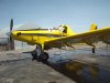
The flying part looks fun, but going back and forth into your chemical spray doesn't seem like a good idea.
No, the flag man is marking where he should fly his passes. No memory necessary.
thanks. I didn't realize that's what he was doing (I had the volume off at work). Talk about a crappy job.
I figured the newer ones had some type of GPS tracking. My neighbor who is a farmer said their tractors use GPS to help with the fields. Someone said this film is circa 1970s, so I'm thinking he's doing it totally by memory.
The flying part looks fun, but going back and forth into your chemical spray doesn't seem like a good idea.
GPS is growing leaps and bounds in agriculture. The last ground-based spray rig I ran a few years ago had WAAS-accuracy GPS. Putting dry fertilizer or liquid nitrogen down on fields that didn't have rows was like flying a LOC approach at 20mph across a bumpy field.
Some of the larger farmers were actually putting their own antennas up to use for signal correction to get down to inch-level accuracy for their fields. They were literally letting the auto-steer on the tractor plant their fields. They could use the GPS in the fall when putting down fertilizer so they only applied fertilizer to the exact point where the seed would be planted the following spring.
The stereotype of "dirt-head stupid farmer" has never been accurate, but now, on top of having an in-depth knowledge plant/animal biology, finance, weather patterns, mechanics, fluid dynamics, etc. the farmers are also learning how to manage computer technology.
yea. straight rows used to be a matter of pride for farmers. now it just shows the ones who have the money for a GPS-steer tractor
I installed auto steer GPS on my tractor for the first time this year. It gets me to one inch accuracy. Everyone talks of the straight rows but I bought it for strip till and the fact every year the rows will be in the same spot in the field.
Add to the VRT applications, in growing season spectral mapping of the fields to identify and treat problem areas. Amazing technology, but it will only be cost effective with drone use.
Putting dry fertilizer or liquid nitrogen down on fields that didn't have rows was like flying a LOC approach at 20mph across a bumpy field.
Liquid nitrogen?? Is that a farming term for some kind of liquid fertilizer than contains nitrogen? Or are you actually dumping liquid nitrogen onto the field?