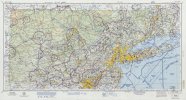
Old / historical sectional charts?

Dana

Final Approach
Joined
Oct 19, 2016
Messages
6,583
Location
CT & NY
Display Name
Dana
Home Airfield
KSNC
Does anybody know where (or if) I can find images of older sectional or terminal area charts? Or does anybody still have old charts that they'd be willing to scan or even photograph a small part of?

I'm specifically looking for the NY sectional and/or terminal chart from the 1985-86 timeframe. Don't need the whole chart, just the area within about 60 miles of NYC, and maybe the top edge of the Washington sectional as far as south as MJX.
 
They have some really old ones, but nothing from the time period I'm interested in.
The site is both slow-af and organized poorly. I bet they're in there soooooooooomewhere :)
 
Does anybody know where (or if) I can find images of older sectional or terminal area charts? Or does anybody still have old charts that they'd be willing to scan or even photograph a small part of?

I'm specifically looking for the NY sectional and/or terminal chart from the 1985-86 timeframe. Don't need the whole chart, just the area within about 60 miles of NYC, and maybe the top edge of the Washington sectional as far as south as MJX.
you writing a novel?
 
Do you have a few specific questions? Some of us flew in that area in the period in question. The Library of Congress has many old sectionals, but for whatever reason, they end around the year 1970. Here is a piece from the 500Mb 1970 TIF you can download. There's also a more manageable decent res jpeg option; the smallest files you can download are worthless. Amazing how many airports on LI, including public seaplane bases w/fuel in many cases. Those were disappeared by a machine called the helicopter.

iiif-service_gmd_gmd370m_g3701m_g3701pm_gct00089_ca002673r-full-pct_25-0-default.jpg
 
I'm trying to identify a fairly tall radio tower that I think existed in the early 1980s but was gone by 1991, north of Lakewood along the Garden State Parkway. It was unusual in that it had a platform on top and a shack on the platform. Now there was a fire tower in Lakewood itself, but the fire tower wasn't that tall and didn't have the platform that was larger than the shack as I recall. But I could be misremembering.
 
The 1970 chart shows a number of towers east of the GSP ranging from about 300' to almost 600'. These are north of Lakewood in the sense of being north of the exit for Lakewood, which is the usual NJ nomenclature in my experience. The fire tower was only about 140' tall and I think closer to Lakeland, but it's been a long time since flown in the area.
 
This would have been close to the Parkway, between Lakewood and Monmouth airports. There's still a tower there today (actually in Brick), though it may be a different or replacement tower; it doesn't look the same. Or I may be confusing it with a tower somewhere else in NJ, and maybe the one I remember (with the shack on top) wasn't the one near Lakewood.
 
Even more recent ones seem destined for collectivity. I’ve also been nursed off paper charts, took a while.
 
Back
Top