MBDiagMan
Final Approach
Does this feature work at all airports or only with multiple runways? I flew out of a one runway municipal airport to another single runway municipal yesterday and never saw the warning.
Does this feature work at all airports or only with multiple runways? I flew out of a one runway municipal airport to another single runway municipal yesterday and never saw the warning.
Someone mentioned they think you only get the feature if you've paid for georeferenced approach plates. I haven't checked.
Someone mentioned they think you only get the feature if you've paid for georeferenced approach plates. I haven't checked.
I mentioned that I got the warning at Sidnaw, which has no approaches, light, tower, pavement, etc. So geo referenced approach plates certainly have nothing to do with it!
It is a base feature. I have it, and I only have the base subscription.
Hmm. Visual and audible alerts are on. Interesting.
Tonight was a simple VFR flight and I didn't put the iPad on the yoke, nor plug it into the intercom for a 0.6 hop to KLMO. It was probably in Karen's lap when it was talking.
Definitely didn't say anything at the hold line at LMO. Wasn't in view at APA for takeoff or landing.
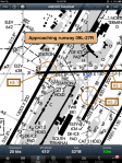
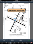
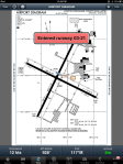
http://blog.foreflight.com/2012/08/...dds-runway-proximity-advisor-x-plane-support/Runway Proximity Advisor
The Runway Proximity Advisor is a visual and audio alerting feature – designed to help reduce runway incursions – that advises you when ForeFlight Mobile predicts your aircraft is approaching, entering, or crossing a runway.
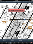
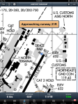
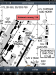
Runway Proximity Advisor will display a visual alert on any ForeFlight screen and announce the name of the runway you are approaching, entering, or crossing. ForeFlight Mobile is aware of hold-short locations and offsets (e.g. on high speed taxiways) for certain airports, resulting in more precise annunciations at those airports. Here are a few screenshots of the RPA in action:
A bluetooth aviation headset capable of utilizing the Bluetooth audio streams from iOS – such as the recently released Lightspeed Zulu.2 - is required for audio alerts. Headsets with an “aux in” port are compatible using a standard 3.5mm audio cable. We’ll update the list of compatible headsets as we hear from different headset manufacturers.
Runway Proximity Advisor was made possible through the FAA’s sponsored research of MITRE, which laid the groundwork for this helpful safety feature. ForeFlight enhanced the original deliverable by adding more airport coverage, corrections, and a commitment to ongoing maintenance of the underlying airport geospatial data that drives RPA.
Fair 'nuff.
Foreflight didn't say anything to me at any runways tonight, I just realized. Interesting.
Is it defaulted "on" or did you have to turn it on?
I only just realized it didn't say anything just now, hours after the flight. Heh. Didn't really notice nor care during the flight.
Now I'll have to look and see if it's "off" somewhere in settings.
The hold-short line at my local airport used to be much closer to the runway, until it was moved back within the past couple of years. I have no idea if the decision to realign the hold short line was arbitrary, or done for compliance reasons, but regardless, I suspect that the data ForeFlight is using for my field is not up to date.
I doubt any database has the precise location of hold-short lines, so they probably base it off some standard distance from the runway edge. They recently moved our hold-short lines, too.
I suspect that there is some standard for location of the hold short lines which perhaps is not reflected in ForeFlight's data. ForeFlight never claims to warn relative to the hold short lines, but I would expect it to warn me that I'm approaching a runway before I'm just about to roll onto it, which it does not appear to do at my home airport.
JKG
ForeFlight Mobile is aware of hold-short locations and offsets (e.g. on high speed taxiways) for certain airports, resulting in more precise annunciations at those airports.

[/B]Right from my earlier post which was from the ForeFlight blog.
if you don't have the bandwidth to be able to taxi, look out the window, control the airplane and be entering your flight plan in your 430/530/etc you should not be operating any kind of heavy machinery . . .
Does this feature work at all airports or only with multiple runways? I flew out of a one runway municipal airport to another single runway municipal yesterday and never saw the warning.
It was never intended to be a primary stop gap or warming system...but it appears to be intended as a second layer of protection. Maybe if Comm Air Flight 191 had this feature it would have saved 49 lives, a nice aircraft and a big black eye to aviation.
If we don't need this kind of technology because we can simply read the "big painted signs", then turn in your GPS and XM Nexrad Weather and just stick with your ADF and Mark 2 eyeballs. They work too without all this Gee Wiz digital technology.
Gene
Hmmmmmm.........I load the FP at the hangar or in the runup area with parking brake set. But then I'm an old geezer with limited processing capability.


Sure, I like technology, but it has become a crutch to too many young pilots. They can't do mental math and plan a divert in their heads and fly at the same time without that magic GPS. What ever happened to TLAR navigation and fuel estimates.
Sure, I like technology, but it has become a crutch to too many young pilots. They can't do mental math and plan a divert in their heads and fly at the same time without that magic GPS. What ever happened to TLAR navigation and fuel estimates.
I agree with Goodish. It's almost to the point that if you're NOT using these available technologies you may not be meeting the minimum standard of care required of a pilot in 2012, from a legal liability (not necessarily FAA) point of view.
I've decided to let my student pilots who've demonstrated proficiency in the FAA mandated "old school" chart-plotting techniques to make additional x-c flights using their iPad/Nexus/etc. That's what they will be using when they're done with training so now is the time to teach them how to use it effectively.
Says the heavy iron pilots that clip wings passing on taxiways, or wing tips clip tails as they pass parked airplanes.
+1. I'll be waiting for the first reference to any best practices material that endorses such activity. It's the same as texting while driving,and all's youse gotta do is watch them weaving on the taxiway to know which guys are trying to drive and punch buttons at the same time. The peanut gallery needs to know the following:
Don't do it, especially if you want to look like a pro. The pros you want to emulate are those who understand the need to get this stuff done on a timely basis and allow sufficient time to get it done before anything moves.
My CFI is doing the same. Also, for all the preflight information, he said it doesn't matter at all where you get it. If you want to use Foreflight to get the weather information, then go for it.
I think relying on something like Foreflight as the only thing I know, for preflight information is perfectly fine. If for some reason I lose my iPad, or Foreflight goes out of business, I can simply not fly until I find an alternative source for the same information.
Sorry..........
But I still look at all those deadly CFIT accidents...........that could have been avoided with the magic of GPS, had it been available at the time. I don't buy into the thought.........that "old school" was good enough.
Sure.... GPS can be a crutch, but why not? It can actually keep your head, "more" out of the cockpit, if used correctly. It's called total information at a glance.
L.Adamson --- and I flew before GPS too.
I agree with Goodish. It's almost to the point that if you're NOT using these available technologies you may not be meeting the minimum standard of care required of a pilot in 2012, from a legal liability (not necessarily FAA) point of view.
I've decided to let my student pilots who've demonstrated proficiency in the FAA mandated "old school" chart-plotting techniques to make additional x-c flights using their iPad/Nexus/etc. That's what they will be using when they're done with training so now is the time to teach them how to use it effectively.
Look at the NTSB accident report for the CAP C-182 with G1000 that had a CFIT in the dark. GPS with moving map and terrain displays will not save you from CFIT. GPS is nice, but you need to kow how to use it.
I agree, but if you disable the GPS, dead batteries in a handheld, 1/2 way to destination. Can they still get there old school? I like your style, show me first that you can do it without GPS, then show me you can use GPS and still fly.
What do you consider as old school? Pilotage, VOR nav, both?
")
What do you consider as old school? Pilotage, VOR nav, both?
What if your new plane isn't equipped with VOR nav radios. I know that many of us "experimental" aircraft builders are not wasting the money on them.
I have not had a dead GPS in 19 years. Have not lost a signal for 18 years. I've used five Garmin aviation GPS's since that time, and one Lowrance. Always use the aircraft's power & batteries for backup. Also carry a backup GPS. In the meantime, I always follow along on "current" charts. All long mountain cross country flights, are always pre-planned. I've never much cared for VOR's in all these years. They're line of sight, and don't work much of the time, in the mountain country I fly in. IMO....compared to GPS, triangulation is a waste, and involves more head down time. I'm very happy to see part of the VOR network dismantled. It can go down in history, along with the nav systems that preceeded it.
L.Adamson
Look at the NTSB accident report for the CAP C-182 with G1000 that had a CFIT in the dark. GPS with moving map and terrain displays will not save you from CFIT. GPS is nice, but you need to kow how to use it.
I agree, but if you disable the GPS, dead batteries in a handheld, 1/2 way to destination. Can they still get there old school? I like your style, show me first that you can do it without GPS, then show me you can use GPS and still fly.
I just went to FAA seminar where I being told theat there are many case of loosing GPS signal. And that while relying on GPS pilot still must maintain dead reckoning.
GPS is still controlled by department of defense and can be jammed if necessary.
Also satellite can go bad at any moment if it happens that pilot fly in mountainous area he may loose signal for several minuets just enough to end up in the mountain.
Just like FAA representative said a lot of pilots use GPS without understanding how it works. How many satellites it takes, how many control stations and so on.
Yep, that's exactly what I said. And I require they have paper charts with them.
Good idea. I always do. I even keep them current.


