You are using an out of date browser. It may not display this or other websites correctly.
You should upgrade or use an alternative browser.
You should upgrade or use an alternative browser.
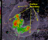
Nearly circular outflow boundary from an air-mass t-storm
- Thread starter TulsaWeather
- Start date
AggieMike88
Touchdown! Greaser!
- Joined
- Jan 13, 2010
- Messages
- 20,805
- Location
- Denton, TX
- Display Name
Display name:
The original "I don't know it all" of aviation.
Cool!! Very interesting to be able to see a visualization of the outflow.
madtrader
Pre-takeoff checklist
Wow. Not a time to be out on Grand Lake.
Jthamilton
Line Up and Wait
Just moved from Tulsa in December. What kind of winds did this create at the boundary?
Your new paint job is quite nice!
Your new paint job is quite nice!
jaybee
Cleared for Takeoff
James if you don't mind, I tried recreating the image you are using...
What product are you using and any special settings to see what you have here ?
It would be very helpful to me to see outflow boundaries where I'm working at.
Thanks.
edit - that paint job is beautiful nice Cardinal !
What product are you using and any special settings to see what you have here ?
It would be very helpful to me to see outflow boundaries where I'm working at.
Thanks.
edit - that paint job is beautiful nice Cardinal !
- Joined
- Jul 3, 2012
- Messages
- 15,252
- Display Name
Display name:
Velocity173
You can see the outflow boundaries on pretty much any doppler radar product. I was on AWC last night and you could see several Tstms over North Georgia with boundaries depicted. Give the storm a wide birth and you'll be good. If not, you'll get a decent jolt out of it.
Last edited:
TulsaWeather
Pre-takeoff checklist
winds were 30-40mph. product was GR-Analyst.
showed up nicely on mobile products like Pykl3 (android) and Radarscope (iStuff)
showed up nicely on mobile products like Pykl3 (android) and Radarscope (iStuff)
AggieMike88
Touchdown! Greaser!
- Joined
- Jan 13, 2010
- Messages
- 20,805
- Location
- Denton, TX
- Display Name
Display name:
The original "I don't know it all" of aviation.
So when do you get to do a weather broadcast while flying that newly repainted Cardinal?
Cruiser
Pre-takeoff checklist

TulsaWeather
Pre-takeoff checklist
NIIIICE!!! Notice the absence of cu over the cooler water of the lake, except for the t-storm....
BillTIZ
Final Approach
This storm was east of Tulsa this evening. Classic airmass TSRA.
Thought y'all might get a kick out of it.
Can you email that to me?