You are using an out of date browser. It may not display this or other websites correctly.
You should upgrade or use an alternative browser.
You should upgrade or use an alternative browser.
[NA]I went for a stroll today[NA]
- Thread starter Let'sgoflying!
- Start date
TangoWhiskey
Touchdown! Greaser!
Guadalupe Peak.
Will you be my hiking guide?
FYI, you didn't have to say "[NA]", because it is aviation related.
Will you be my hiking guide?
FYI, you didn't have to say "[NA]", because it is aviation related.
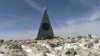
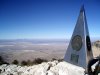
On the summit is a stainless steel pyramid erected by American Airlines in 1958 to commemorate the 100th anniversary of the Butterfield Overland Mail, a stagecoach route that passed south of the mountain. One side of the pyramid has the American Airlines logo. The second side displays a U.S. Postal Service tribute to the Pony Express Riders of the Butterfield Stage. The third side displays a compass with the logo of the Boy Scouts of America. A summit register contained in a metal ammunition box is located at the base of the pyramid.
Last edited:
fgcason
En-Route
Who can tell where?
You went to a pointy object on top of some rocks.
TangoWhiskey
Touchdown! Greaser!
Attachments
Last edited:
Let'sgoflying!
Touchdown! Greaser!
You guys are fast, have you been Troy or did you recognize it...wait, you are able to google a photo?!
Working on story.
Working on story.
Jeanie
Pattern Altitude
That's a good hike Dave. I have backpacked up there before and stayed a couple of days. It was the hottest day on record at the park 107* and frankly, the ranger should have said NO you can't go do that... but I rested about every 5 mins or so or whenever there was shade !
Beautiful country we have out here. Who says there aren't mountains in Texas?
Beautiful country we have out here. Who says there aren't mountains in Texas?
Let'sgoflying!
Touchdown! Greaser!
Wow Jeanie that is unbelievable, way too hot to be packing!
As you say, many are still surprised to learn of mountains in Texas- I was. This peak is at 8750' and the highest in the state. I have flown past, and around it many times and finally got to hike it yesterday.
Wiki link to the park
I drove out of town in the dark, with a full moon setting in front of me about 5:30am yesterday, arriving at the park as the sun rose around 8am. I started out on the 8.5mi, 3000' vertical trail. It was clear, calm and only 35F but I quickly warmed up on the switchbacks with the sun. After the first hour the trail went around the other side of the mountain into the shadow, and where the wind was blasting - suddenly it became very cold and I wondered if I'd done right to cache an 'excess' sweater a ways back. Also the dry rocky trail became hard packed snow, and slippery. Fully the next 2 miles were like that. The trail edges were dotted with spanish daggers and I was constantly afraid I'd slip and impale myself on one. Tough going for the next 2 hours. At one point the drifts were almost knee-high and I had serious doubts of success.
The trail has several false summits - where you think you are on the last leg of the climb but are disheartened to see higher ones beyond once you get higher. No distance markers at all. So it's a little bit of a mind-game. As I climbed, the air got thinner and I was pumping a lot of it. The double packed cell donation the day before didn't help I suppose. By 11am I'd made it to about the 8000' level and still was not sure I would summit. The remaining trail was clear of snow and in the sun, but the breeze was getting brisk and I was played out. I found some shelter, and pulled out my secret weapon. An orange. There is nothing like it to bring renewed strength! I still could not move fast but I was making progress on the final push. Short sections at a time then rest, service the oxygen debt. At 11:57 I got up the final section of path and could see over the peak! There was the shiny stainless pyramidal monument left by American Airlines in 1958. And an ammo box where you could write in a book. The book was just filled so I used the back cover. Wished I had time to flip through it but I was dragging myself around from exhaustion and the breeze was wickedly cold. I sat in the lee of it for a while, eating my sandwich and checking out the terrific view. I could see Sierra Blanca peak covered in snow abt 80mi to the north, and the Davis mountains where I live, over 100mi south. The plains of the Tx panhandle stretched to the ene. Inspiring.
The trip back down took half as long; 2 hrs and was harder on the legs fighting the ice but not nearly as c-v stressful. It is going to take a full 24hrs to recover but I am glad I did it! Now I can say I have been to the lowest (gulf coast) and highest points in the state!
A few more pics:
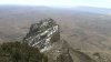
El Capitan, a lower peak.
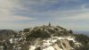
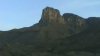
Guadalupe mountain from the highway
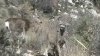
I was surprised by these dudes, only life I saw on the way up. They came towards me out of curiosity.
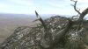
One view.
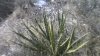
Spanish Dagger, yucca - sharp as a butcher's knife.
As you say, many are still surprised to learn of mountains in Texas- I was. This peak is at 8750' and the highest in the state. I have flown past, and around it many times and finally got to hike it yesterday.
Wiki link to the park
I drove out of town in the dark, with a full moon setting in front of me about 5:30am yesterday, arriving at the park as the sun rose around 8am. I started out on the 8.5mi, 3000' vertical trail. It was clear, calm and only 35F but I quickly warmed up on the switchbacks with the sun. After the first hour the trail went around the other side of the mountain into the shadow, and where the wind was blasting - suddenly it became very cold and I wondered if I'd done right to cache an 'excess' sweater a ways back. Also the dry rocky trail became hard packed snow, and slippery. Fully the next 2 miles were like that. The trail edges were dotted with spanish daggers and I was constantly afraid I'd slip and impale myself on one. Tough going for the next 2 hours. At one point the drifts were almost knee-high and I had serious doubts of success.
The trail has several false summits - where you think you are on the last leg of the climb but are disheartened to see higher ones beyond once you get higher. No distance markers at all. So it's a little bit of a mind-game. As I climbed, the air got thinner and I was pumping a lot of it. The double packed cell donation the day before didn't help I suppose. By 11am I'd made it to about the 8000' level and still was not sure I would summit. The remaining trail was clear of snow and in the sun, but the breeze was getting brisk and I was played out. I found some shelter, and pulled out my secret weapon. An orange. There is nothing like it to bring renewed strength! I still could not move fast but I was making progress on the final push. Short sections at a time then rest, service the oxygen debt. At 11:57 I got up the final section of path and could see over the peak! There was the shiny stainless pyramidal monument left by American Airlines in 1958. And an ammo box where you could write in a book. The book was just filled so I used the back cover. Wished I had time to flip through it but I was dragging myself around from exhaustion and the breeze was wickedly cold. I sat in the lee of it for a while, eating my sandwich and checking out the terrific view. I could see Sierra Blanca peak covered in snow abt 80mi to the north, and the Davis mountains where I live, over 100mi south. The plains of the Tx panhandle stretched to the ene. Inspiring.
The trip back down took half as long; 2 hrs and was harder on the legs fighting the ice but not nearly as c-v stressful. It is going to take a full 24hrs to recover but I am glad I did it! Now I can say I have been to the lowest (gulf coast) and highest points in the state!
A few more pics:
El Capitan, a lower peak.
Guadalupe mountain from the highway
I was surprised by these dudes, only life I saw on the way up. They came towards me out of curiosity.
One view.
Spanish Dagger, yucca - sharp as a butcher's knife.
Attachments
TangoWhiskey
Touchdown! Greaser!
Wow, thanks for the write up Dave. Was the trail clear at the point where the drifts where knee high? I was at first imagining you trudging through knee-high snow, but I think that visual isn't what actually occurred. Is the entire trek walkable? From the highway view, that looks like a steep cliff wall to the peak.