Minnesota Father and 3 sons missing in Wyoming.

This is the actual Teton 3 departure shot on Thrusday the 28th. There are Dragons in them there hills....bottoms at 7,500, tops at 9,000.

The real "Teton 3" are in the photo.

As someone who has stood on top of both the Grand Teton and Gannett Peak, I can say I prefer climbing them over flying around them any day of the week and twice on Sundays. Except - maybe - in the winter.
 
I mislabelled it. It was the GEYSR4.NALSI departure (northbound). I've never hiked these, most of my hiking is in Summit County, CO.

Still, not a place near which you'd like to land out....
 
Last edited:
The real "Teton 3" are in the photo.

As someone who has stood on top of both the Grand Teton and Gannett Peak, I can say I prefer climbing them over flying around them any day of the week and twice on Sundays. Except - maybe - in the winter.
Here's what they look like when you can see all of them. However I'm the lazy sort and will choose flying over climbing. That looks pretty steep...

attachment.php
 

Attachments

  • Tetons.JPG
    Tetons.JPG
    72.8 KB · Views: 114
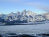
I have always thought the Grand Tetons were Awesome. Here is a Google view from about 16500. I don't see why anyone would attempt crossing at A. Even at B, there is a big difference (6,000 ft) from valley bottom to the peak (7500 ft to 13500). Crossing just a bit north at C, there is just about a 2000 ft difference valley to peak (8500 valley, 10,500 ridge), and only being 6 miles to cross the worst and 12 miles total, it seems that crossing at 16500 ft, risk would be small.

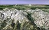
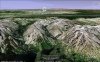
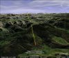
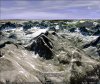
Now, crossing the Wind River Range at 14,500, I don't think I would try even on a calm day. Here is a Google view from about 14500. Most of the terrain is over 10K ft for 15 miles to the peak, and probably just as much on the other side. The yellow line represents the 15 miles. The last Google view shows Gannet peak on the left and the yellow arrow 6 miles, approximately where the crash occurred.

Even though the Tetons are Grand with 6 to 7K ft from valleys to peaks, it looks like a piece of cake compared to the Wind River range. For crossing the Wind River, I would insist on the max altitude allowed, VFR, or simply go around. If I was IFR capable, I don't think I would consider crossing either.
 

Attachments

  • teton (Small).jpg
    teton (Small).jpg
    118.6 KB · Views: 12
  • teton1 (Small).jpg
    teton1 (Small).jpg
    104.1 KB · Views: 8
  • wind river.jpg
    wind river.jpg
    81.7 KB · Views: 12
  • crash.jpg
    crash.jpg
    102.6 KB · Views: 12
So let me ask this of mountain flyers. say you are flying toward a mountain and encounter mountain wave, it is my understanding that you fly at an angle toward the rock so if you encounter the wave you can turn around quicker a turn of say 130 degrees vs 180. but what if you are flying over the mountain from the windward side then get slammed down by the wave. Ya can't turn back to the mountain so waddaya do?

Well, if approaching from the windward side, before you get to the ridge you will encounter an express elevator for the flight levels. The common error is to cut the throttle and put the nose down, this is BAD. You climb with the lift, because soon after you clear the ridge you are going to hit the express elevator to Hell. At that point you put the nose down for Vno and fly out of it as quickly as you can.

This kind of stuff is why I won't fly IMC in the mountains in anything that isn't turbojet powered and able to climb out to 10k AGL quickly. Personally I need to see the terrain so I can visualize the air currents. I need to "see" where the lifts, drops and eddys are going to be. The eddys are your "outs" if you get into trouble. I also want to be able to see if there are standing lenticulars, this is where real danger lies.

And watch out for the rotors on the leeward side. If you hit one of those suckers make sure you pull back on the power, slow to manoeuvering speed and try not to fight the turbulance too much as you may stress/over-stress the airframe.
 
Back
Top