Marker Beacons

It does when the aircraft lacks a functioning transponder.

Thank you. Saved me the trouble. Amusingly, during this period Margy was a student pilot and the owner of the flying club booked her a tour with the control tower. Getting up to the radar room I looked down and said "I see you got the primary radar fixed." The controller said that most people would not have noticed that.
 
It's not like that at all. Communications is required at the MEA and up. It does not have to be direct pilot-controller communications. Where that does not exist position reports and ATC instructions are relayed through FSS. That's why FSS is addressed as "Radio".


Can't file and fly the MOCA when /G these days, eh? No Comm assured there.

I know it was pretty flat where you worked, but we see folks below Comm coverage all the time out here. And definitely below MEA.

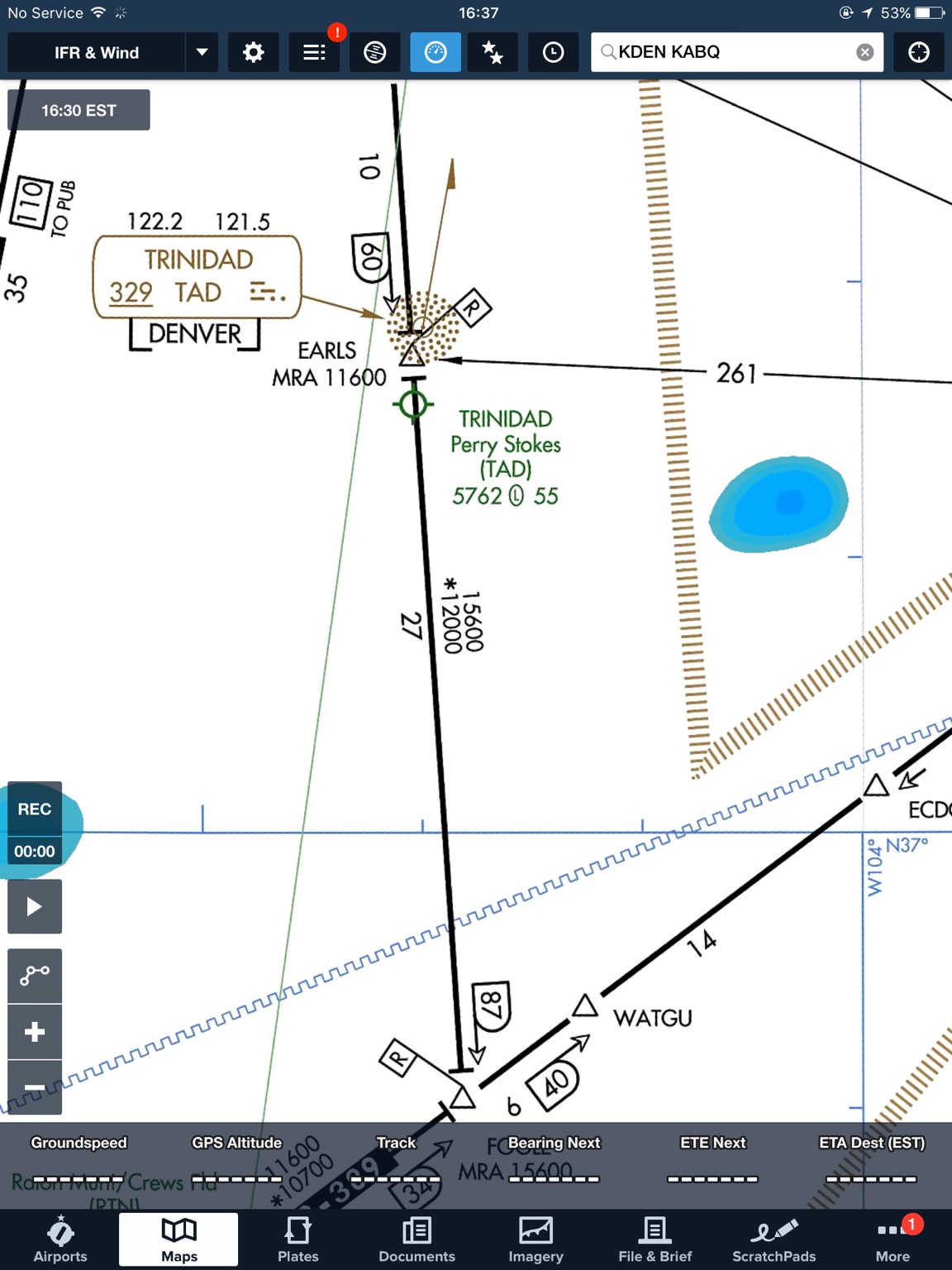
You gonna request fly the MEA over Trinidad in a non-turbo single and have to suck on O2 just so you can have a chat with ATC? No.

And does that airspace REALLY need much "control"? You might see another aircraft, maybe one... By the time you get to Pueblo. Would have been three, but only on a weekend, and then the restaurant closed.

Or maybe it reopened? Or whatever. Yawn.

The SS lead team likes to use the hangar to the west of Flower to stage the Presidential motorcade. About the only time you see any real traffic at PUB anymore.
 
c58206490cb72e619e130b6b70a5e1e1.jpg


Forgot the screenshot for Trinidad. Plenty of other examples. I just picked one.
 
Can't file and fly the MOCA when /G these days, eh? No Comm assured there.

Not beyond 22 miles from the NAVAID without radar. Never could.

I know it was pretty flat where you worked, but we see folks below Comm coverage all the time out here. And definitely below MEA.

Comm coverage exists at the MEA. Operations between the MEA and MOCA requires radar beyond 22 miles of the NAVAID and that takes us outside the scope of this discussion.

You gonna request fly the MEA over Trinidad in a non-turbo single and have to suck on O2 just so you can have a chat with ATC? No.

If radar is not available the MEA is the lowest altitude available. Doesn't matter what's requested.
 
Not beyond 22 miles from the NAVAID without radar. Never could.


Comm coverage exists at the MEA. Operations between the MEA and MOCA requires radar beyond 22 miles of the NAVAID and that takes us outside the scope of this discussion.


If radar is not available the MEA is the lowest altitude available. Doesn't matter what's requested.


Where is "22 miles from the GPS satellite"?

There's all sorts of places where FAA claims radar is "available" out West here where it really isn't. There's no Notams saying that anything is Out of Service either.

Wanna go for a ride to Vegas from Denver? I'll show you where the chart lies. All we have to do is wait for ABQ to say they'll talk to us again in a half an hour. I know of three places off of the top of my head where if there ever was any radar service there or planned service, it isn't there today.

Anyway as usual you're off on some tangent.

The point was in response to the fact that virtually none of that airspace needs "controlling" and yet the creeping crud of Class G loss continues there. There's almost zero traffic. Especially on a weekday mid-week.

Lovely places. Quite desolate. No point at all in making most of it controlled airspace other than as a make-work jobs program.
 
91.177(2) In any other case, an altitude of 1,000 feet above the highest obstacle within a horizontal distance of 4 nautical miles from the course to be flown. However, if both a MEA and a MOCA are prescribed for a particular route or route segment, a person may operate an aircraft below the MEA down to, but not below, the MOCA, within 22 nautical miles of the VOR concerned (based on the pilot's reasonable estimate of that distance).


The VOR's are tested to 22 nautical miles unless the AFD states the VOR is unusable for navigation below XXX altitude on XXX heading due to loss of line of sight or other issues
 
Bangor doesn't have a CAT II approach. It used to have CAT II and CAT III approaches. They're gone, but the IM remains.

We must be looking at different charts:
 

Attachments

  • KBGR.jpg
    KBGR.jpg
    313.4 KB · Views: 13
Where is "22 miles from the GPS satellite"?

The NAVAIDs are VORs, VORTACs, or TACANs.

There's all sorts of places where FAA claims radar is "available" out West here where it really isn't. There's no Notams saying that anything is Out of Service either.
Please provide credible evidence.

Wanna go for a ride to Vegas from Denver? I'll show you where the chart lies. All we have to do is wait for ABQ to say they'll talk to us again in a half an hour. I know of three places off of the top of my head where if there ever was any radar service there or planned service, it isn't there today.
I'd be happy to, just send me funds to cover all of my travel and related expenses.

Anyway as usual you're off on some tangent.
Not me. You.

First, you said control was not possible without radar. I pointed out that ATC was provided without any radar for a long time.

Then you said ATC was provided outside of communications coverage. I pointed out that communications was required at the MEA.

Then you implied flight at the MOCA without communications or radar was possible for aircraft filed /G. I pointed out that operations beyond 22 miles from the NAVAIDs defining the airway required radar.

In each case I have responded directly to your statements.

The point was in response to the fact that virtually none of that airspace needs "controlling" and yet the creeping crud of Class G loss continues there. There's almost zero traffic. Especially on a weekday mid-week.

Lovely places. Quite desolate. No point at all in making most of it controlled airspace other than as a make-work jobs program.
The airspace is controlled. Whether or not it should be is a different matter.


ORDER 8260.19G Flight Procedures and Airspace

Chapter 2. General Procedures

Section 2-9. Communications and Weather

2-9-1. Communications requirements.
Order 8200.1, chapter 8, defines communication tolerances and flight inspection procedures. Even though gaps in navigation course guidance may be approved, reliable communications coverage over the entire airway or route segment at minimum en route IFR altitudes must be available.

a. MEAs or MAAs are predicated upon continuous approved communications capability for the entire designated segment. All available resources must be explored before restricting the use of altitudes of an airway or route due to a lack of acceptable communications coverage. Coordination must be effected with ATC for determination of the acceptability of communications coverage in a particular area.

b. Mandatory communications with the appropriate ARTCC are not required; communications with other ATC facilities are allowable. Where necessary, in order to provide direct communications with a center, appropriate recommendations for a peripheral site should be made.

c. Communications requirements for non-14 CFR part 95 routes certified for a particular air carrier are the responsibility of appropriate Flight Standards Division Office (FSDO) operations inspector.


ORDER JO 7110.65W Air Traffic Control

Chapter 4. IFR

Section 5. Altitude Assignment and Verification

4−5−6. MINIMUM EN ROUTE ALTITUDES


Except as provided in subparas a and b below, assign
altitudes at or above the MEA for the route segment
being flown. When a lower MEA for subsequent
segments of the route is applicable, issue the lower
MEA only after the aircraft is over or past the
Fix/NAVAID beyond which the lower MEA applies
unless a crossing restriction at or above the higher
MEA is issued.

a. An aircraft may be cleared below the MEA but
not below the MOCA for the route segment being
flown if the altitude assigned is at least 300 feet above
the floor of controlled airspace and one of the
following conditions are met:

NOTE−
Controllers must be aware that in the event of radio
communications failure, a pilot will climb to the MEA for
the route segment being flown.


1. Nonradar procedures are used only within
22 miles of a VOR, VORTAC, or TACAN.

2. Radar procedures are used only when an
operational advantage is realized and the following
actions are taken:

(a) Radar navigational guidance is provided
until the aircraft is within 22 miles of the NAVAID,
and

(b) Lost communications instructions are
issued.

 
The airspace is controlled. Whether or not it should be is a different matter.


Good lord Ron.

You badly want to avoid that point didn't you, since it was the real question being posed.

Go back and read my comments from the beginning with the assumption that I knew all of that which you posted from the start, and also how it really gets done operationally out west here where the chart lies about where there's both Comm and Radar coverage and everyone just falls back on that last paragraph of yours... tell the pilot the lost Comm procedure.

Which in reality works out to be, "See ya in half an hour."

Anyone going anywhere /G in the desert southwest is going to get that more than once.

Now apply to the topic we are actually talking about. Loss of class G. There's really no reason for it. Nobody is *really* controlling Jack Schidt (our intrepid /G pilot who'd like to remain below 15,000 today) out there.

But they want that airspace. All the way to the surface wherever possible. No idea why. Maybe they will build better comm and talk to the cacti. LOL.
 
But they want that airspace. All the way to the surface wherever possible. No idea why. Maybe they will build better comm and talk to the cacti. LOL.
Not to the surface. To 1,200 agl (1,500 in Alaska).

It's all about NextGen and random routing below 14,500. ATC had long given up trying to keep random route IFR within controlled airspace. The ATC policy became, "If the pilot files or requests a random route he has implicitly stated his intention to operate in Class G airspace should such exist along his random route." Turns out since the advent of GPS there were a significant increase in unwitting IFR/IMC operations in Class G airspace. It was setting up for another "Grand Canyon" (TWA/UAL June, 1956).
 
It was setting up for another "Grand Canyon" (TWA/UAL June, 1956).


It still will be, after the airspace designator is changed in the (very real) areas where radar and ADS-B won't cover. Nothing changes.

Well, ADS-B will warn aircraft to aircraft in those places, but I wouldn't call that "controlled".
 
What I see happening is that if it can be controlled airspace, it's going to be controlled airspace. The communication requirement I don't think is going to be much of a hinderence almost anywhere. It doesn't have to be direct communication with the controlling ATC facility. It doesn't even have to be verbal as far as I can tell. ATC communication via data link has been going on for a long time already over the ocean. I don't know, but it might even be happening domestically already in some areas, like maybe Alaska. Someone here will know.
 
It still will be, after the airspace designator is changed in the (very real) areas where radar and ADS-B won't cover. Nothing changes.

Well, ADS-B will warn aircraft to aircraft in those places, but I wouldn't call that "controlled".

IFR separation standards have to be met for IMC in Class E.
 
Ok so here's another increasingly rare item I'd be interested in seeing... Anyone know where you can find a tri-color VASI?

I know KAVX has the not often seen pulsating VASI which I hadn't seen until I moved to SOCAL but I havent seen a tri-color anywhere.
 
Don't know, I always fear this is one of those silly things they put in the FAA requirements that are of no practical use. Sort of like having to study all that gook on MLS systems for years.

I do have a portable VASI (mil spec) sitting in my hangar. Our problem is it's not too bright and by the time it gets dark and we think about setting it up to play with, we've already been drinking...

According to Wikipedia, the tri-color's are popular in Eastern Europe, Russia and other CIS states but was hoping to find one a bit closer to home seeing as I dont plan on flying myself (or at all) to those locations anytime in the near future; not that I wouldnt mind visiting, just not something on the agenda.
 
Can the Garmin 430 be made to beep when you come to a waypoint?
 
So how'd the date go?

Great, though the girlfriend doesn't care for stalls. :p (This was her fourth time flying, I went out specifically to practice slow flight and stalls and invited her along.)

Bangor doesn't have a CAT II approach. It used to have CAT II and CAT III approaches. They're gone, but the IM remains.

Ah, didn't know that. And Bangor does still have a CAT II approach for runway 15 so that makes sense.
 
Great, though the girlfriend doesn't care for stalls. :p (This was her fourth time flying, I went out specifically to practice slow flight and stalls and invited her along.)


Ah, didn't know that. And Bangor does still have a CAT II approach for runway 15 so that makes sense.

CATIII as well.
 
Back
Top