New VFR charts are made available every 56 days, right?
I'm wondering why cases like this exist:
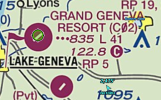
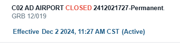
The NOTAM shows the airport has been permanently shutdown since December 2024.
How come we're 8 months later and it's still on the VFR chart?
Also, I couldn't find the meaning of those 3 red dots next to the elevation. Anyone know what those mean?
I'm wondering why cases like this exist:
The NOTAM shows the airport has been permanently shutdown since December 2024.
How come we're 8 months later and it's still on the VFR chart?
Also, I couldn't find the meaning of those 3 red dots next to the elevation. Anyone know what those mean?