Lawreston
En-Route
That's the organization I'm in the process of doing aerial photography for 200 islands along the entire Maine coast. http://www.mita.org/
Board member Maria sits in the copilot seat with a marine chart in-hand and says, "See that one over there? Go there next; then that small island in back of the one that looks like a submarine over on the left"
Round #2 is tomorrow.
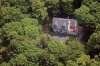
The picture? It's on an island(Georgetown) but not one in the program. It's my house while en route offshore. When I tell people I live in the trees I'm not kidding.
HR
[EDIT] That fir tree at the corner was about five feet tall when I moved here in 2007. Terrific growth factor.
Board member Maria sits in the copilot seat with a marine chart in-hand and says, "See that one over there? Go there next; then that small island in back of the one that looks like a submarine over on the left"
Round #2 is tomorrow.
The picture? It's on an island(Georgetown) but not one in the program. It's my house while en route offshore. When I tell people I live in the trees I'm not kidding.
HR
[EDIT] That fir tree at the corner was about five feet tall when I moved here in 2007. Terrific growth factor.
Attachments
Last edited: