Looking for tips - flight over Yosemite

onwards

Pattern Altitude
Joined
Jul 6, 2011
Messages
1,998
Location
CA
Display Name

Display name:
onwards
I'm hoping some folks here will have useful tips for a flight I am planning for the weekend (weather willing).

The plane is a 182 with an 18K ft service ceiling, originating in CCR.

I've never flown over Yosemite, but think the views should be fantastic. I am aware of the 2000ft AGL restriction, so plan to make the flight at 14,000ft MSL over the park itself, but that should be for about 20 minutes or so if I'm understanding the chart right.

I looked over the chart and have come up with this route:

Fly east towards the Yosemite Valley. Enter the mountains between Pine Mountain Lake (E45) and Mariposa (MPI). Continue flying ESE, aiming to pass Mt. Clark to the south, heading east towards Mammoth Lake (MMH). Turn north, and fly along the east of the mountains until Lee Vining (O23) over Mono Lake. Turn west, head over Tioga pass, and then straight west towards Columbia and head into town for lunch before going back.

May make stop-n-gos at MMH and O24 just so I can add them to my list.

So what do you think? is this a good route? am I missing something crucial?
 
Can't help you with route details, I bet you have a good survival pack and will draw your route for family - I was impressed with how rough it was and lack of clear, flat areas. Bring photos back here!
 
Where is your fuel stop?

All I'll say about flying that area is there are some choice routes. I won't say where but they are plain to see on the sectional.
 
There is a fix, ELCAP, right over the park. Makes it easy to find.
 

Attachments

  • DSC00070.JPG
    DSC00070.JPG
    697.5 KB · Views: 128
Pine Mountain Lake is a great little airport. We flew in there one day from So Cal for a days river rafting trip.
Have fun.
 
Do you know how good your tolerance is for high altitude flight without oxygen? This has very little to do with your overall fitness. At 14000ft most people will be significantly impaired, even after only a few minutes. The FAA rules are very liberal on this, you'll need to be more conservative than they are in order to be safe unless you have a pulse oximeter.

Personally my tolerance is very good. I've been cruising along at 13500 showing 90% on the oximeter while my friends in the back seat were feeling very, very sleepy. I don't do that any more.
 
I aways fly Mammoth Pass when I cross the Sierras in that area (I go to KBIH a lot). You don't have to get much over 10,000 feet to make that pass. Mo altitude mo betta though.

Prevailing winds are generally blowing to the East which helps carry you over the mountains/pass in that direction. On the way back from MMH you should plan on circling to get a comfortable altitude before crossing the pass. In any case, always fly to one side of the range if it's narrow, and approach any crossing or pass at an angle so you can turn back if you need to.

Don't try to do a straight shot and cross the desolation wilderness even if you are above 15K. A landing there would not be survivable. Plan your route so you can maximize hospitable terrain within your glide path.
 
Where is your fuel stop?

All I'll say about flying that area is there are some choice routes. I won't say where but they are plain to see on the sectional.

No need for one; with long-range tanks, this plane can fly for well over 5 hours. I'm guessing we'll be in the air for less than 3 (45m each way to the mountains, another hour maybe for the cross and crossback, and a bit of buffer).
 
I aways fly Mammoth Pass when I cross the Sierras in that area (I go to KBIH a lot). You don't have to get much over 10,000 feet to make that pass. Mo altitude mo betta though.

Prevailing winds are generally blowing to the East which helps carry you over the mountains/pass in that direction. On the way back from MMH you should plan on circling to get a comfortable altitude before crossing the pass. In any case, always fly to one side of the range if it's narrow, and approach any crossing or pass at an angle so you can turn back if you need to.

Don't try to do a straight shot and cross the desolation wilderness even if you are above 15K. A landing there would not be survivable. Plan your route so you can maximize hospitable terrain within your glide path.

Oh, that's great to know... I was looking at the chart and figuring I'd have to go 14K because of the FAA limitation on low altitude flying over Yosemite. If I can stay at, say, 12K, I'd be a much happier camper. Would that work along my planned route, then? at least going east? coming back from Mono I don't have the same problem in terms of minimum altitude.

I took a seminar on mountain flying last month and they also mentioned the idea of coming in at an angle, which I thought was a great tip.
 
you won't need to be at 14k for much of the park in order to remain >2k agl. You also won't see much that high!
 
What an incredible flight!

The morning started with an extensive weather briefing, since I had never flown this high or over the Sierras, and wanted to make sure I didn't miss something big. But while conditions at my home airport (CCR) were on the verge of marginal because of haze, the mountains were totally clear under FL200.

Drove out and met my copilot - a student pilot I've met and who is just about to get to her solo - and got the plane ready. It was fun to be on the experienced side for a change, and get to explain things about the 182 that are different than the 172 she is training in.

We got out finally around 10:30AM, into the haze which covered everything up to about 6000ft all the way to the Sierras themselves. It pretty much stayed that way the whole day. Still, visibility was decent and we climbed quickly to 7500 heading east. My plan was to go more or less over MPI before heading east, threading south of Mt Ritter and intercepting V230 before crossing Mammoth Pass.

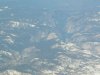
The first indication that this was going to be a very special flight was when we were getting close to the mountains en route to MPI, and climbed to FL95. It was almost like flying between cloud layers - the haze layer underneath, at that particular point and altitude, looked almost solid if you didn't stare it too hard, and the FL200 overcast on top gave a "sandwich" feeling, with us as the filling and the snowy mountain ranges in front of us looking entirely magical. With the air being so stable it was like floating in a dreamland.

Flying over Yosemite was beyond words. I just can't describe it; she took lots of photos and as soon as I get them, I'll post them to my flickr photostream and link from here. We got as high as FL125 heading east before intercepting V230, and seeing Mammoth Pass emerge as we came around Mt Ritter I could in my mind paint the airway between the mountains peaks.

At that point I had a request from OAK center to relay a message to a lost plane. I tried but no luck. He was lost over the mountains, apparently; I do hope not to see a report about that anytime soon.

We got through Mammoth Pass and made a beeline to MMH. At 7300 elevation, it is by far the highest airport I ever landed in. With the weather so calm, and the sky so clear (both clouds on top and haze were gone once we got to the mountains, as per the weather briefing), it was a breeze to get in. The lady at the FBO there, Carrie, was beyond super nice, and we treated ourselves to a couple snacks before heading back out.

Did I mention climb performance? or lack thereof? I had already noticed how hard the 182 was working to gain altitude in the mountains; taking off from MMH it became very noticeable, as the 800-900 fpm I am used to without trying too hard at sea level became more like "500 fpm with a lot of concentration". Headed north to Mono Lake, and surrounded the big hill south of Lee Vining (O24) to make a touch-n-go there. Without a doubt, this was one of the most beautiful air strips I have ever landed in, sitting as it does right at the edge of the lake, what with an absolutely crisp day making everything seem like it was high-def. I was so preoccupied with the scenery I forgot to turn carb-heat off on the "go" part of the touch-n-go, which led to a few seconds of anxiety as my climb performance went to something like 200 fpm, trying to desperately get off the ground in this high elevation. A quick scan of controls pointed out the problem.

I then circled once to get up to FL105 before trying to brave the Sierras west of Lee Vining. Got close and started feeling the turbulence, and told my copilot "you know something? I want more altitude before trying this". Spent another few minutes in a big circle gaining another 1500ft and got back in. The peaks in that area are as high as 13,500, and it looked it. But it was absolutely stunning.

I spent the next 20 minutes both awed by the scenery and in high concentration mode, trying to gain some more altitude and getting as high as 13,800 before getting past the real high peaks. A frozen Tioga Pass provided another amazing moment, and pointing the nose towards Columbia, some of the sheer drops into the Yosemite valley were breath taking.

Came in over Columbia (O22) way too high, so pointed the nose down and lost about 3000ft in two minutes. Ouch, the ears. Landed in Columbia, went to the old town and grabbed lunch, and came back for the last leg of our journey back to CCR.

Which is when I looked at my copilot and asked "wanna try something new?". She knew immediately what I was talking about, and nodded enthusiastically. We took off from runway 29, the soft (grass) field. A textbook soft field takeoff made me appreciate all the elements of it, in particular the need to roll onto the soft field so as not to get stuck. But with the nose leading high we got off with no trouble. It was my first ever actual soft field experience, and while it was kinda cool, I have no desire to attempt landing into one at this point without someone far more experienced at the controls. It just felt like too much could go wrong with just a minor error on a landing.

The flight back to CCR was uneventful, although the haze was still heavy, which led to a very uncomfortable moment trying to get downwind on 1R. With the haze being so heavy, and the sun right in my eyes coming in from Bay Point over the hills, for about 10-20 seconds it was really hard to see anything at all. Certainly an interesting effect of the setting sun through the haze.

And that was it. We landed, taxied back to parking, and found out that the Hobbs had logged an impressive 3.8 hours, about an hour more than I thought this was going to take.

It was an incredible experience, and one that I will not soon forget. What a privilege to be out there today!
 
Last edited:
Nice report. Sounds like a good flight. Hope you were leaning properly for best power - climb performance in a 182 with two on board should still be decent at 10500ft (which is not FL105 in the US)
 
Finally got some pictures uploaded to my photo stream. Hope they can give you a sense of the beauty that was surrounding us.
 
Nice report. Sounds like a good flight. Hope you were leaning properly for best power - climb performance in a 182 with two on board should still be decent at 10500ft (which is not FL105 in the US)

I was, and it was decent, just not great. At sea level it easily gets to 900f/m... at 10K it was striving for 500, and at close to 14K, 300 was about it.
 
Oh, that's great to know... I was looking at the chart and figuring I'd have to go 14K because of the FAA limitation on low altitude flying over Yosemite. If I can stay at, say, 12K, I'd be a much happier camper. Would that work along my planned route, then? at least going east? coming back from Mono I don't have the same problem in terms of minimum altitude.

I took a seminar on mountain flying last month and they also mentioned the idea of coming in at an angle, which I thought was a great tip.

"the idea of coming in at an angle"

Perhaps you weren't listening carefully. There's a reason, and not a "great tip", it's geometry. You come in direct, and if something goes wrong, you need a 180 UTurn. You come in at a 45 angle, you only need a 90 deg turn left or right.

Did the seminar discuss winds over a ridge, thru a pass, etc?

Sheesh. So... did you like the pictures?
 
Resurrecting this thread with a video posted this week. Yet another #AviationBucketList item to add to the list!

 
I went over the high part of the Sierras once. It was crystal clear and calm. There were all these small lakes and a lot of rocks above timberline. It was sort of a plateau. It was west of Bishop I think, north of Mt Whitney for certain. It was fantastic.
 
Back
Top