Long-term forecast ceilings tool?

dukeblue219

Line Up and Wait
Joined
Mar 2, 2012
Messages
811
Location
Silver Spring, MD
Display Name

Display name:
Ted
Hi all, hope somebody can help me find a weather chart that I haven't been able to find on my own.

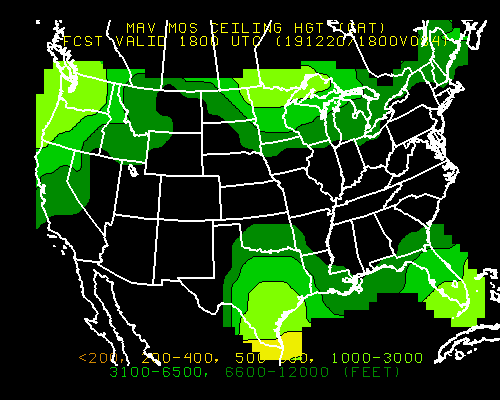
I'm looking for a graphical depiction of forecast ceilings several days in advance (3-10 days). Anybody know where I can find such a thing?

I'm not looking for a perfect forecast of course, but I like to look at the long range models (out to 10 days) to see how the national and global weather patterns are developing as a long flight draws closer. I look at things like SL pressure, precip, 500mb heights and similar, but I swear I found a link on this board a few weeks ago to a great chart showing just ceiling. Anybody know what I'm talking about? Thanks!
 
I think experimental ADDS has this somewhere..looks like they have changed the site though from when I last used it...seems like they had long range stuff
http://weather.aero/
 
Remember anything more than a couple of days out is a wild-eyed guess.
 
Remember anything more than a couple of days out is a wild-eyed guess.

Still nice to see how the trends are developing ahead of time. The "big picture" stuff tends to be reasonably close 6-8 days out even if it's no guarantee what the precip rates or cloud cover will be like in a specific city or state at that point.
 
I use this site, air sport net. They give a graphic 3 day forecast based on the predicted Skew-T.
http://usairnet.com/cgi-bin/launch/code.cgi?sta=KFNL&model=avn&state=CO&Submit=Change+Location

Thanks, I've seen similar looking data, but it might have been at a different site. I'm really looking for something like this:18hr ceiling

That's from the RAP but is just 18 hrs out.

EDIT - Just found this link which may be what I was thinking of. http://www.nws.noaa.gov/mdl/forecast/graphics/MEX/ which generates the following:

MAV.BCIG.026.gif


It can produce GFS/NAM/GFSX graphical products including ceiling for the NAM and GFS a few days (3+) out. For example, I can pull up the probability of a 1000-3000' ceiling on Tuesday 00z which is pretty cool. I know it's just a computer model, but it's still helpful to get a sense of whether a particular trip is likely to happen or not (which of course would be based on actual and short term forecasts later on).
 
Last edited:
why bother - you are not going to fly the model they use - and they flip flop like crazy. Just wait til its time to fly and go take a look outside.
 
why bother - you are not going to fly the model they use - and they flip flop like crazy. Just wait til its time to fly and go take a look outside.

Yeah, I know. If you fly all the time it's probably no big deal. But, I tend to make cross country trips once a month or less, so if I need to be somewhere I like to know way ahead of time what the likelihood is of making the trip successfully because I'm also balancing alternate means of transport. I don't enjoy waiting until Friday to get a prog chart for my Sunday return when there's perfectly good weather information available.

If I look at the models 5-6 days out and see a big cold front sweeping though I can't predict exactly what it will be like, but I know what the dominating weather phenomena is going to be in the area. Just gives me something to do in advance and get ready for the flight.

But you're right that in the end, the decision will be made the day of based on actual conditions and short-term forecast info.
 
A crystal ball?

I don't bother looking at anything more in-depth than the Weather Channel (weather.com) for anything farther out than the TAFs; Nothing's that reliable/accurate. Hell, even today the TAFs were calling for low ceilings and IFR pretty much all day today up until early morning; Turned out to be a great VFR flying day with a few clouds scattered about.
 
Try USAIRNET.COM
 
I'll third usairnet. When I was full time instructing that would be the first thing I looked at for planning and scheduling flights. It's an Awesome tool. It's just a forecast, so it's just a big guess, but they are pretty close most of the time. You can at least expect to see the trend they show.
 
Yeah, I know. If you fly all the time it's probably no big deal. But, I tend to make cross country trips once a month or less, so if I need to be somewhere I like to know way ahead of time what the likelihood is of making the trip successfully because I'm also balancing alternate means of transport. I don't enjoy waiting until Friday to get a prog chart for my Sunday return when there's perfectly good weather information available.

If I look at the models 5-6 days out and see a big cold front sweeping though I can't predict exactly what it will be like, but I know what the dominating weather phenomena is going to be in the area. Just gives me something to do in advance and get ready for the flight.

But you're right that in the end, the decision will be made the day of based on actual conditions and short-term forecast info.

I used to stress it like you - then I just realized there is nothing I can do about it - and even though I've heard its VFR 90% of the time its only VFR about half the time you want to fly in the real world . . .

You might want or need to make a trip but if you are VFR only or flying non-fiki in winter - then you have to also have +/- 1-2 days of schedule flexibility . . . or you don't fly GA.
 
Wicked old necro thread, I know.. but are there any new tools? Foreflight killed the MOS tool it seems and I'm trying to get some forecasting 2 days out. wunderground just gives a little cloud symbol.. big difference though if that cloud is at 2K or 12K

Anything else out there other than usairnet.com ?
 
Cloudbase tool in Windy.com. It gives a pretty granular visual depiction. You can click on a specific spot and get a number for a given time at that spot. I've found it to be reasonably accurate 2-3 days out. Windy__Cloud_base.jpg
 
Thanks, I will check it out
 
Back
Top