Jaybird180
Final Approach
Any recommended resouces for learning airspace? Like 'Airspace for Dummies' series.
A good bit of the chart to practice with is Western Oklahoma. LOTS of things going on out there to challenge your brain and chart reading skills.
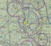
Speaking of challenge 10,000 "whose line is it anyway" points to whomever can correctly identify the airspace around Aldus AFB. (What do the dark grey lines mean. This was a favorite "trip you up" election of my DPE).
Any recommended resouces for learning airspace? Like 'Airspace for Dummies' series.
This was a favorite "trip you up" election of my DPE).
Not a trip you up around here. MBS, AZO, MKG are all TRSA. My favorite trip you up, is what is a double open magenta circle?
The FAA teaches this backwards. If you look at chapter 14 of the pilots handbook of aeronautical knowledge they start with class A and work their way down. I start with G and work my way up. Let me explain:
A good bit of the chart to practice with is Western Oklahoma. LOTS of things going on out there to challenge your brain and chart reading skills.
Speaking of challenge 10,000 "whose line is it anyway" points to whomever can correctly identify the airspace around Aldus AFB. (What do the dark grey lines mean. This was a favorite "trip you up" election of my DPE).
Also check out the little airport in the lower right! (KFDR)
Oddly enough the current A/FD doesn't list LTS as having TRSA service, even though it's depicted on the sectional and AirNav indicates Stage III communications, but it does identify the following airports as having TRSA service
AGS, AVP, AZO, BAK, BGM, BPT, CXY, DWU, ELM, ERI, FAI, FAR, FSM, GGG, GPT, GRF, GTF, I41, ILM, LCH, MBS, MCN, MDT, MGM, MKG, MLU, PSP, RFD, TRI, WRB, YNG
not all of which are class D airports.
...consistently inconsistent...
I laughed out loud, Arnold at your Gods airspace comments - I might steal it ... I know another person who refers to it as the airspace for gutsy pilots
I had to really study airspace since it's pure memorization.
Here's how I remember the basic airspace classes:
A - Above
B - Big Cities
C - Cities
D - Dashed line
E - Everywhere Else
G - Ground
This site has a good picture showing airspace examples:
http://macklow.com/airspace/
My DPE asked me this question:
Q: "Why do visibility requirements increase above 10,000?"
A: Because speed restrictions increase
The restrictions actually decrease, allowing for higher speeds.
so what you're saying is 400kts is a decrease from 250 kts? lol
it's like when is next weekend (this weekend or the next weekend)
or a higher vacuum
or inflammable