Bryce Salmi
Filing Flight Plan
- Joined
- Dec 1, 2019
- Messages
- 11
- Display Name
Display name:
KB1LQC
Hey all,
I recently moved up to the Bay Area from Los Angeles and am thinking of planning a camping trip to Stovepipe Wells L09. This would be a VFR flight so definitely will be flexible on out/return times and/or with cancellation. That said this would be in a C172N (technically a Deltahawk STC) and in the end of November 2020. I would love suggestions for planning this route.
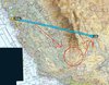
Obviously I need to get over or around the Sierra Nevada mountains. Most obviously it appears that I would need to fly down towards the Kern Valley L05 and Mojave area and then navigate northeast around the mountains. I roughly drew this out in the attached image.
That said, am I missing any obvious paths through/around the Sierra Nevada mountains? I know the service ceiling of the plane is 14,200 MSL but I don't want to assume it's a good idea to pick any path I can safely get over the mountains and go for it. That seems like asking for some mountain wind phenomenon or unnecessary hazardous force landing regions. I'd rather ask people who may have flown this route and get some firsthand tips.
I recently moved up to the Bay Area from Los Angeles and am thinking of planning a camping trip to Stovepipe Wells L09. This would be a VFR flight so definitely will be flexible on out/return times and/or with cancellation. That said this would be in a C172N (technically a Deltahawk STC) and in the end of November 2020. I would love suggestions for planning this route.
Obviously I need to get over or around the Sierra Nevada mountains. Most obviously it appears that I would need to fly down towards the Kern Valley L05 and Mojave area and then navigate northeast around the mountains. I roughly drew this out in the attached image.
That said, am I missing any obvious paths through/around the Sierra Nevada mountains? I know the service ceiling of the plane is 14,200 MSL but I don't want to assume it's a good idea to pick any path I can safely get over the mountains and go for it. That seems like asking for some mountain wind phenomenon or unnecessary hazardous force landing regions. I'd rather ask people who may have flown this route and get some firsthand tips.
 . Well I’ll be danged, there’s a Bakersville in NC. That’s what I call Bakersfield, that or more often Bakersburg.
