poadeleted20
Deleted
- Joined
- Apr 8, 2005
- Messages
- 31,250
How about furlongs per fortnight?I might try Yards per Hour. It will make me feel better flying west bound.
How about furlongs per fortnight?I might try Yards per Hour. It will make me feel better flying west bound.
Agreed. My Cub's ASI is in mph only; it would be just about as useful with only the colored arcs.Not really, the ASI isn't all that bloody critical to flying that it be calibrated to any particular speed. As far as the flying part goes it could just as easily be marked with V speeds: Vso, Vx, Vy, L/Dmax, Va, Cruise, Vno, Max Cruise, Vne.
Where it makes a difference is in navigation and your airspeed isn't particularly useful in those regards where as ground speed measured in knots gives you slight advantage over statute mile or kilometer measurements
Regardless what is used on your ASI, you'll have to use knots and nautical miles when dealing with ATC.
That's true, however if you are using airways... flying an instrument approach.. all of those distances and information are provided in nautical miles
You can always replace it, you know? BTW, our Arrow has an Aspen that indicates mph, and one of those ASIs that have a little TAS scroller. Once the speed gets high enough to hit the scroller, it's too difficult to read. Fortunately, it's only for backup these days.Knots, and the dual MPH/KTS ASI in the Arrow I fly drives me up the freakin' wall.
You can always replace it, you know? BTW, our Arrow has an Aspen that indicates mph, and one of those ASIs that have a little TAS scroller. Once the speed gets high enough to hit the scroller, it's too difficult to read. Fortunately, it's only for backup these days.
MPH for me since that's the predominant marking on my airspeed indicator and what the references are in the POH. It is also easier to speak MPH to young eagles I'm flying since they can relate to it.


+1
How many time have you been talking to non flyers and you have to explain what a knot is? What a waste of time. We need to bring more people into the sport not make it more "elite" by using an antiquated using of measure.
Pilots use knots
Aviators use MPH
The statute mile was so-named because it was defined by an English Act of Parliament in 1593, during the reign of Queen Elizabeth I. The statute states: "A Mile ſhall contain eight Furlongs, every Furlong forty Poles, and every Pole ſixteen Foot and a half." (35 Eliz. cap. 6.)[39] It was thus 1760 yards (5280 feet, about 1609 metres).[12] For surveying, the statute mile is divided into eight furlongs; each furlong into ten chains; each chain into four rods (also known as poles or perches); and each rod into 25 links. This makes the rod equal to 5½ yards or 16½ feet in both Imperial and US usage.
The nautical mile was originally defined as one minute of arc along a meridian of the Earth.[50] Navigators use dividers to step off the distance between two points on the navigational chart, then place the open dividers against the minutes-of-latitude scale at the edge of the chart, and read off the distance in nautical miles
As for Nautical Miles this:
The only thing I can conclude from your analysis of the situation is that you are a Republican.

Now that was funny!
Okay, why do we use statute miles to describe visibility? And altitude in feet? Satellites are measured with statute miles above the earth.
 That has brought me so much joy into my life, NOT!. They use rods to measure portage distances in Canada. Do NOT mistake 700 rods for 700' like I did once!.
  Carrying a 80 pound canoe on your back for 2.2 MILES is not what I call fun.
How about furlongs per fortnight?
Now that was funny!
Okay, why do we use statute miles to describe visibility? And altitude in feet? Satellites are measured with statute miles above the earth.
"Because Jesus died on the cross for your sins, now shut up and eat your broccoli..." Same reason we do everything here, otherwise we'd be using that heathen metric system that you need a full set of fingers to use.
"Because Jesus died on the cross for your sins, now shut up and eat your broccoli..." Same reason we do everything here, otherwise we'd be using that heathen metric system that you need a full set of fingers to use.
Fraction of c. I'm a small guy, I fly a small airplane, and I like small numbers.
"Because Jesus died on the cross for your sins, now shut up and eat your broccoli..." Same reason we do everything here, otherwise we'd be using that heathen metric system that you need a full set of fingers to use.
I remember getting into a debate in high school with a teacher. He claimed the imperial system was all arbitrary while the metric system was scientific.
I asked him "What's the basis for the meter?"
He went on about how it was based on the wavelength of some excited state of Kr gas. And my response was "So, someone arbitrarily selected that gas, and arbitrarily selected that particular state. It's still arbitrary, someone just abstracted it to make it sound sciencey"
For airplane performance and limitation issues that's the right choice. For that matter the ASI doesn't indicate speed, it indicates dynamic pressure and ought to be marked in PSI, Bar, or HectoPascals. Or better yet one of those pressure units to the half power since that's more representative of aerodynamic performance and would make the computation of TAS easier.I use whatever the airplane is equipped with.
100 knots = 0.0000174148% c
Right, my issue is not with arbitrariness of the base as much as the ease of use. The imperial system is very wasteful in time and materials in industry as people waste more time making calculations and are more prone to error using the Imperial system. Although, a kilo gram being based on a liter of fresh water, we lose a considerable amount of your arbitrariness argument.


^ What he said.
I know we don't use this in our everyday flying, but the way that knots, nautical miles and the lat/lon system interface is amazing.
I had it all explained to me a few years ago by an old man who was a NASA ballistics expert in the 70's and now circumnavigates by himself on his 30 foot sloop using celestial navigation and dead reckoning.
 ...
...
 ..
..That's 17414.8 nanoCs. Sounds like a lot to me.100 knots = 0.0000174148% c
This must have been the same NASA rocket scientist that miscalculated the distance for the Martian lander and sent it into the surface of mars at 400+MPH because of a conversion error..
That was only a 450 million dollar mistake...
In all seriousness... I would love to find an oldtimer show me how this celestial navagation process really works... In my mind there are too many moving targets..
Ben.
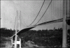
This stuff too (Tacoma Narrows Bridge, Minneapolis I35W Bridge, Hyatt-Regency walkway):Oh Pshaw...
They built this stuff using old, decrepit measuring systems:
This must have been the same NASA rocket scientist that miscalculated the distance for the Martian lander and sent it into the surface of mars at 400+MPH because of a conversion error..
100 knots = 0.0000174148% c

This is a science teacher? Meters (or "metres," to more historically accurate) were around long before anyone could measure the wavelength of the excited state of Krypton gas. Dates back to the 18th century, when it was defined as one ten-millionth of the distance from the Earth's equator to the North Pole at sea level. In any event, it was not arbitrary -- they really were trying to come up with a physical basis.I remember getting into a debate in high school with a teacher. He claimed the imperial system was all arbitrary while the metric system was scientific.
I asked him "What's the basis for the meter?"
He went on about how it was based on the wavelength of some excited state of Kr gas. And my response was "So, someone arbitrarily selected that gas, and arbitrarily selected that particular state. It's still arbitrary, someone just abstracted it to make it sound sciencey"
I ain't that damn old, but I still came up in a time when celestial was our primary nav across the ocean. Amazing what a quarter century can bring.
It's really not that difficult. .
With a really solid overcast you can't top, more or less, if LORAN wasn't available. You got low enough to see the surface so you can use the driftmeter and revert to wind triangles to DR your way across. And yes, I did have the opportunity to navigate off a driftmenter in a T-29 almost 40 years ago. Dunno what the ship-drivers did in that case.Thanks Henning..... I get the concept and the geometry involved, it is the properly identifying the correct stars and doing it fast enough to make some sense of it all that has me worried.. Also.. I am assuming on a cloudly night you are screwed ?
Oh Pshaw...
They built this stuff using old, decrepit measuring systems:
What does that have to do with what I said? I said it was more wasteful, not impossible. How does showing multiple boondoggle projects discredit that?Thanks Henning..... I get the concept and the geometry involved, it is the properly identifying the correct stars and doing it fast enough to make some sense of it all that has me worried.. Also.. I am assuming on a cloudly night you are screwed ?
You have three times of day when you take sights, dawn, local noon and dusk. If you cannot see your celestial bodies at those times, you are screwed. We got in a hurricane on the way back from Hawaii once, we had no clue of where we were outside 1000nm for a week, no sights, just kept the wind off the port quarter and drove the waves.
Identifying stars is easy, get a 'Starfinder' wheel (or 'app' these days) and you find it's really easy to recognize the 5 you'll use.
When the Nav Star system and Magnavox 4102 receiver came out, it was 'wow' you could get a solid fix or two a day on most days even if the clouds were there..unless they had lightning in them then eeeeeeehhhh, maybe. It even had a DR function that you could program to run between fixes.
I used the first public GPS unit Furuno released. On the way from LA to SF it was all over the hemisphere. I thought 'damn, if this is the latest greatest, it sucks'. Furuno came aboard in SF though and swapped out a bad board. For the rest of the trip it was very accurate even on the georef to the 'lollypop' on the new radar. THAT was better than sliced freakin bread, had never seen anything like it before.
With a really solid overcast you can't top, more or less, if LORAN wasn't available. You got low enough to see the surface so you can use the driftmeter and revert to wind triangles to DR your way across. And yes, I did have the opportunity to navigate off a driftmenter in a T-29 almost 40 years ago. Dunno what the ship-drivers did in that case.
I am too. Wasn't that the Canadian Parliament building?Notre Dame and the Empire State Building were boondogles?