Klamath Falls, OR Anyone? Anyone?

KeyWestPhotog

Pre-takeoff checklist
Joined
Dec 11, 2012
Messages
206
Location
Chesapeake, VA
Display Name

Display name:
WingMan
I'll be flying commercial out of Key West to Klamath Falls, OR on Saturday. I'll take 2 days to enjoy the area, then begin hopping via C172 back here to Key West.

Anyone in that area, or familiar with it that can toss me some "do's and don'ts" for that area, or maybe in flight planning on the way home?
 
Expect smoky skies. Watch out for all the fire TFRs, particularly if you head west to check out the coast. It is one of the worst years on record for fires in Oregon. There are other fire TFRs throughout the west; that happens every summer.

Hopefully they'll have them somewhat better controlled by then (they can linger on till winter, though,) but the only two times I was up in the last couple weeks up near Eugene it was pretty hazy even there. I would expect it is much worse in Klamath Falls area. It didn't look too bad in eastern Oregon.

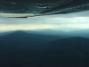
To give you an idea of some of the haze, I took the first attached picture yesterday at 8500 ft, looking north from somewhere close to Crescent Lake, 5S2. At the time KEUG reported ceilings at 15,000 ft. You can just barely make out the snowy Sisters peaks, only about 35 miles away. (I was returning to home to Creswell, 77S, from Christmas Valley, 62S. Just for the heck of it.) On a decent day Mount Hood, about 110 miles away, would be visible.

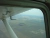
Only caution is to make sure to take photos (and videos, if equipped) and post some here, lest yee be ostracized. Aviate, navigate, communicate, take pictures. For instance, I saw the interesting formation in the second attached photo and it wasn't till I looked it up when I got back home that I discovered it was the main attraction of Fort Rock State Park, Oregon.
 

Attachments

  • 011.png
    011.png
    572 KB · Views: 19
  • FortRockSP.jpg
    FortRockSP.jpg
    302 KB · Views: 23
Thank goodness your going East!
Depending on your risk tolerance, make direct to KWMC, then follow I 80 over KLWL, KRKS, KRWL, KCYS. The idea is get and stay in gliding distance of civilization if you have a problem until the terrain begins to fall away past eastern Wy. Also I 80 is also where the lowest terrain is thru there, most cases.
Leave at the crack of dawn, try to get to KCYS before noon. Maybe not possible in the Cessna, but as others have pointed out you will likely see mountain wave if winds are perpendicular to the ridges, and they likely will be. Just ride them up, don't try to hold altitude unless you are too high and dont have o2, as you might need the altitude for the down wave. 2k over the ridges if the winds are over 20 is what I use, tighten that up as you see fit.
Watch the DA'S out there, they can hit 10k pretty easy, so be prepared to lean on takeoff. It will get rough after the ground heats up so you may want to split the western end of your trip over two days. KLGU has a great FBO, reasonable gas, a car to to use. Just stopped there last week, great service.
Lots or restricted and SUAs out there, FF is recommended but you won't have radar service in north western nevada, south western ID unless very high.
Have fun
 
Last edited:
I'll be flying commercial out of Key West to Klamath Falls, OR on Saturday. I'll take 2 days to enjoy the area, then begin hopping via C172 back here to Key West.

Anyone in that area, or familiar with it that can toss me some "do's and don'ts" for that area, or maybe in flight planning on the way home?

Please tell us of your trip when done. Have done something similar a couple times but at a quicker pace. Will be good to hear your story. You ARE stopping at Jay's hotel......:yes:
 
Fly direct to Burley Id. then Rock Springs, it is all down hill from there.

It's a low crossing, but remember Rock Springs is over 7000'. It is summer still, and the DA will kill ya.
 
Fly direct to Burley Id. then Rock Springs, it is all down hill from there.
There's some 8000-9000' terrain along the Wasatch Front on that route. I-90 is a bit lower, and generally friendlier terrain. Marias Pass (US Hwy 2 along the south border of Glacier National Park) is lower still, but it's a rather narrow, winding valley with high peaks on either side - easily the most scenic route.

It's a low crossing, but remember Rock Springs is over 7000'. It is summer still, and the DA will kill ya.
Here's our departure from RKS around this time last year. It was a warm day, with DA well over 8,000'. Our 180 hp C-172 rolled over 1,800' before it lifted off.

http://youtu.be/lPLOcfzqRM8
 
There's some 8000-9000' terrain along the Wasatch Front on that route. I-90 is a bit lower, and generally friendlier terrain. Marias Pass (US Hwy 2 along the south border of Glacier National Park) is lower still, but it's a rather narrow, winding valley with high peaks on either side - easily the most scenic route.

Here's our departure from RKS around this time last year. It was a warm day, with DA well over 8,000'. Our 180 hp C-172 rolled over 1,800' before it lifted off.

http://youtu.be/lPLOcfzqRM8

Flying the north end of the rockies you are over hostile terrain for 3-4 hours, Burley to Rock springs. is a very easy crossing where most of the terrane is a lot less hostile the Wasatch range starts south of the route that you will be on by a route direct Rock Springs.

first picture northern Rockies taken at 10,000"
second picture the Wasatch range from 10,000' , take a left at this point to go to Rock Springs
 

Attachments

  • P1010018.JPG
    P1010018.JPG
    697 KB · Views: 12
  • Texas Trip 99 031.jpg
    Texas Trip 99 031.jpg
    145.9 KB · Views: 10
Last edited:
Thanks for sharing your knowledge fellas. From my previous trip that took me into Washington I was able to appreciate the +2k ft AGL spacing in the mountains :)

Until I do get out of the mountains it will be "sunrise/wheel up" take offs for the first few days.

Just doing some "online" planning this was my initial planning for the flight. After reading the experiences you guys have shared, I'm going to look into other planning as well.
 
Left Klamath Falls this morning just after sun up after waiting for awhile on them to let us out to the plane. I couldn't of asked for better weather, and a beautiful view.

Got into Winnemucca, NV for our pee/gas/food/stretch legs stop. Temperatures were already getting into the upper 80's so we boogied on out of there. Upon entering the pattern we spotted some Pronghorn Antelope out bouncing across the pasture.

Just after noon'sh we got into Richfield, UT and boy can this place use some rain. Gonna shower up in the Hampton Inn here then look for a place to eat out in town. Tomorrow it looks as if we are tentatively going to ping pong a little bit playing with our safety margin in the mountains, but I'll see about doing some refining of the flight plan. If the weather holds up it'll be a cool 54 degrees taking off at sunrise tomorrow.

 
Last edited:
After today's adventure, I've come to realize that flying through the mountains is a whole lot more fun than flying across the waters in the Florida Keys.

I like being able to say "see that big ass rock, I want to stay to the left of that thing" and being able to look outside at the scenery instead of constantly watching the HI for an hour or so before I even get to see land.

I just plugged the route you posted yesterday (krif u13 1l7 bdg 00c 1v0 nm24 razlo kguy) into WingX and it sure looks like you had some tall rocks to cross.

All downhill from this point I presume. At least you can fly where there is more O2 if you like.

Did you take any pictures?
 
I didn't get any photos as I was the one flying and not having a cell phone with a charge. :(

This is a X-Country I would love to do all over again, but I would prefer to have a plane with an autopilot that worked. :) just to be spoiled and enjoy the scenery.
 
Back
Top