TMetzinger
Final Approach
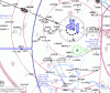
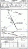
If an airport is within Class B airspace, is it just assumed that radar is required for approaches? I ask because I'm looking at the KHEF ILS 16L approach, and I see an IAF with no published radial or feeder route, and then the other two fixes are marked as RADAR.
So, I cannot see how a /A or /U aircraft would fly this approach without ATC, but I don't see any "Radar Required" note on the chart anywhere.
I may have answered my own question - MANNE is an enroute fix as well as the IAF, so it's possible to find it on the LO enroute chart, and the other two fixes have cross radials listed, so it's possible to navigate without radar I guess. I'm just not used to seeing the IAF "undefined" on the plate. Perhaps I got spoiled by Jepp charts that may put more information on them.
Attachments
Last edited:
")