Teller1900
En-Route
This is kind of a long one...
I always have my camera with me when I fly. It's in my flight bag until I do the pre-flight, and then it moves to the map pocket for the duration of the day's flying. I have just under 700 pictures from the last eight months of flying between KLEB and KLGA (and a few others in there too). For the last three weeks, though, I've been on a new route (KAUG, KBOS, KISP) so I haven't been taking the camera in the cockpit so I could focus on learning the route and frequencies. Things have been getting more comfortable these last few days and with SEVERE clear dominating the entire area, today seemed like a good day to bring the camera along again.
Today was an easy day. 0500 show for a 0600 go. The route takes us AUG-BOS-ISP-BOS-AUG, done around 1145. Winds were whipping at about 7kts in BOS, and a whopping 3kts in ISP...and brutally clm in AUG. Visibility was well over 50 miles and not a cloud in the sky...perfect day for photos, and for flying in general.
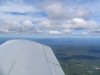
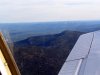
The first photo is on extended right base for 27. They had asked for best forward speed at this point, so we were indicating 220kts when I took this...hence the blurriness. Just after I snapped the photo, Final Approach cleared us for the visual 33L (the runway they were using for takeoff). The previous approach controller had told us to expect 27, so we were a bit confused. A quick query cleared up the confusion and we were cleared for the visual 27.
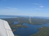
Picture 2: as we make the turn from base to final we come in off the water...these are some of the houses and resorts right along the water on final.
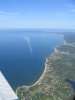
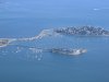
Picture 3: final for 27. Of course we hauled all the way to five mile final when they "asked" us to slow immediately to final approach speed as we had a rather stunning closure rate on the FedEx 76- ahead of us. Those are some seriously expensive houses that line the breakwater around the airport...not bad location, I'd say.
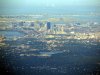
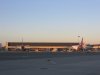
Pic 4: FedEx parking right behind our gates. These are two of the 9 FedEx heavies that were on the ground at the time.
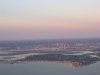
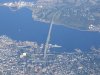
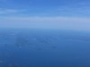
Pic 5: A battleship, destroyer, and sub moored in Providence...not really sure why they're there, but they've been there for a while now. We're at 9,000 feet, to give you some idea of how clear it was today.
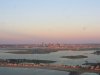
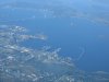
Pic 6: The USS Forrestal on the left and USS Saratoga on the right. Both Viet Nam era ships are slated to be scuttled somewhere out in the Atlantic to create an artificial reef. You might recognize the Forrestal as the carrier from which the infamous C-130 t/o and landings occured. It's a shame to see them go.
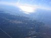
Pic 7: Westhampton, NY (KFOK) and the late morning sunrise as we fly up Long Island toward the Hampton VOR and on back up to BOS.
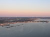
Pic 8: Houses resorts and a marina at the tip of Long Island (Long Island sound on the top, ocean on the bottom).
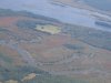
Pic 9: The Maine coast. That's NAS Brunswick middle left with AUG 10-15 minutes to the north.
Pic 10: About five miles from the airport...the leaves are starting to change all over Maine...it's really quite impressive.
I love Boston. Their taxi instructions are awful, especially with one runway and two major taxiways closed, but the number of planes they can move at a time is incredible. On clear days, they can land two runways and takeoff one (or t/o two, land one if the demand is there) with little to no crossing needed. On days that LGA would have 2 hour ground stops and 40-50 planes in line for t/o...BOS is running smoother than most airports in the north east. Just another day livin the life.
I always have my camera with me when I fly. It's in my flight bag until I do the pre-flight, and then it moves to the map pocket for the duration of the day's flying. I have just under 700 pictures from the last eight months of flying between KLEB and KLGA (and a few others in there too). For the last three weeks, though, I've been on a new route (KAUG, KBOS, KISP) so I haven't been taking the camera in the cockpit so I could focus on learning the route and frequencies. Things have been getting more comfortable these last few days and with SEVERE clear dominating the entire area, today seemed like a good day to bring the camera along again.
Today was an easy day. 0500 show for a 0600 go. The route takes us AUG-BOS-ISP-BOS-AUG, done around 1145. Winds were whipping at about 7kts in BOS, and a whopping 3kts in ISP...and brutally clm in AUG. Visibility was well over 50 miles and not a cloud in the sky...perfect day for photos, and for flying in general.
The first photo is on extended right base for 27. They had asked for best forward speed at this point, so we were indicating 220kts when I took this...hence the blurriness. Just after I snapped the photo, Final Approach cleared us for the visual 33L (the runway they were using for takeoff). The previous approach controller had told us to expect 27, so we were a bit confused. A quick query cleared up the confusion and we were cleared for the visual 27.
Picture 2: as we make the turn from base to final we come in off the water...these are some of the houses and resorts right along the water on final.
Picture 3: final for 27. Of course we hauled all the way to five mile final when they "asked" us to slow immediately to final approach speed as we had a rather stunning closure rate on the FedEx 76- ahead of us. Those are some seriously expensive houses that line the breakwater around the airport...not bad location, I'd say.
Pic 4: FedEx parking right behind our gates. These are two of the 9 FedEx heavies that were on the ground at the time.
Pic 5: A battleship, destroyer, and sub moored in Providence...not really sure why they're there, but they've been there for a while now. We're at 9,000 feet, to give you some idea of how clear it was today.
Pic 6: The USS Forrestal on the left and USS Saratoga on the right. Both Viet Nam era ships are slated to be scuttled somewhere out in the Atlantic to create an artificial reef. You might recognize the Forrestal as the carrier from which the infamous C-130 t/o and landings occured. It's a shame to see them go.
Pic 7: Westhampton, NY (KFOK) and the late morning sunrise as we fly up Long Island toward the Hampton VOR and on back up to BOS.
Pic 8: Houses resorts and a marina at the tip of Long Island (Long Island sound on the top, ocean on the bottom).
Pic 9: The Maine coast. That's NAS Brunswick middle left with AUG 10-15 minutes to the north.
Pic 10: About five miles from the airport...the leaves are starting to change all over Maine...it's really quite impressive.
I love Boston. Their taxi instructions are awful, especially with one runway and two major taxiways closed, but the number of planes they can move at a time is incredible. On clear days, they can land two runways and takeoff one (or t/o two, land one if the demand is there) with little to no crossing needed. On days that LGA would have 2 hour ground stops and 40-50 planes in line for t/o...BOS is running smoother than most airports in the north east. Just another day livin the life.
Attachments
-
 IMG_3213.JPG747.3 KB · Views: 30
 -
 IMG_3214.JPG802.2 KB · Views: 23
 -
 IMG_3215.JPG773.4 KB · Views: 20
 -
 IMG_3217.JPG677.1 KB · Views: 24
 -
 IMG_3220.JPG1.4 MB · Views: 31
 -
 IMG_3222.JPG1,011.8 KB · Views: 21
 -
 IMG_3224.JPG859.6 KB · Views: 14
 -
 IMG_3226.JPG980.6 KB · Views: 20
 -
 IMG_3227.JPG781.4 KB · Views: 11
 -
 IMG_3228.JPG1 MB · Views: 17