I got grounded due to wind today, so I thought I would take the time to learn more about foreflight. Turns out you can import .kml files to create custom map layers.
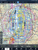
I mapped out the practice areas around Seattle and a 25nm radius circle around KBFI in google earth and exported it as a .kml file. If you open that file in foreflight it will save it as a custom map layer.
I thought I would share it in case any other students in the area would find it useful. These are the practice areas as defined by Galvin, so YMMV.
https://drive.google.com/file/d/1O38b2mkMr65Zl25H_6seHmHxsgT3-235/view?usp=sharing
")