NoBShere
Pre-takeoff checklist
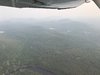
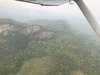
So work has been busy lately and I haven't been flying in about a month. Yesterday I found myself with some free time and the RG was available so let's go poke some holes in the sky and knock out some landings. I took off from RHV (San Jose) and went to E16 (San Martin). On my way out of RHV i noticed some haze but, that is typical this time of year. On my way back to RHV about an hour later, normal stuff, get the weather, contact tower. Around 10 or 15 miles out I had noticed that the haze appeared "thicker". I quickly checked the weather again and visibility was reported at 10 miles and clouds were scattered way above my altitude. I thought Ok, just normal haze no big deal. on my way in, tower advises of an aircraft departing the pattern of my location and the pilot responds that the smoke is thick and he can't see me. When tower advises me of the other aircraft, I respond similarly. Then immediately someone else contacts tower to talk about the smoke. Right about this time, I think i should let them know I can't see the field. Unfortunately, the smoke conversation that tower is having is taking longer than expected but, its providing me with some useful information. I keyed the mic a couple times, hoping they might wrap up so I can talk. Just as they do stop talking, field comes into sight and I am not lined as well as i would have liked but, easily corrected for an uneventful landing.
Part of me says I should have told tower a little earlier about visibility but, it was changing quickly as there was brush fire just north of the field that started after I departed RHV. I didn't know about the brush fire until after I landed. The whole time I thought it was just smoke that had blown in from far away, which can happen. Additionally, with the hills to the east and smaller hill to the south, it appeared the smoke just wasn't blowing out and I may have come through the worst of it. For instance, the tower is on the west side of the field and it was clear there.
As i rolled onto the taxi way, I was reminded of a night flight a few years ago while returning from dinner. Due to the street lights and businesses in the area, I found myself doubting if i was lined up for 31R properly. Just as I started to contact tower to discuss, it became clear I was lined properly. Shortly after that, my nephew was in town and we went on tower tour. I was telling the controller about my questioning of where the runway vs road was on that night flight. Her response was that I'm not the only one and just let us know and we will help you out. My learning from this was just speak up earlier but, I'm not going to beat myself up for thinking through a situation. And a reminder that smoke can behave differently from clouds and fog.