jasc15
Pre-takeoff checklist
I visit PA often to see my girlfriend, and I want to fly from KZER (Schuylkill County) to KUNV (State College) next time I visit. Is this something I could tackle without training?
Thanks guys. You can barely call them mountains, but I didn't want to just dismiss it as being no problem. And good to hear that UNV is good. There are a few around there, and was going to ask which is recommended.
I'd call it "mountain flying lite"No. They are not mountains. They are not even foothills. They still can produce squirrely winds, but nothing like the real thing.
Thanks guys. You can barely call them mountains, but I didn't want to just dismiss it as being no problem. And good to hear that UNV is good. There are a few around there, and was going to ask which is recommended.
Yes those are not mountains, these are mountains.. your PPL training should be equil to the experiance needed to go any where east of the Mississippi
You should be Ok going there.
I'm not going to be as dismissive as Tom is; you can still get some turbulance ad rotors off these smaller mountains when the wind is blowing right and I've seen airports in the valleys get fogged in until the sun rises enough to burn it off.
Thanks guys. You can barely call them mountains, but I didn't want to just dismiss it as being no problem. And good to hear that UNV is good. There are a few around there, and was going to ask which is recommended.
This isn't "Mountain flying" as in "requires special training."
It is different than flying in airport rich, coastal areas where a glance out the window can settle your position within 2 miles.
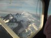
There is a disoreinting sameness to the endless ridges that run angled across Pennsylvania. The northern half is a hilly plateau, with more green-covered emptiness than you'll see anywhere in LI, NJ, DE, or MD combined.
The weather between Laurel Ridge and Blue Mountain (the western and eastern edges of these "mountains") is always -- always -- slightly different than east or west of the ridges, and usually it's worse.
UNV is in a large bowl that contains Happy Valley. When you land, look around at the ridges and realize that it's good to be able to see them.
Flying SEL at night increases risk -- it's doable, but adds risk. Follow a routing over airports for some cushion. Losing the big fan at night over this terrain means you are out of options. Sheer luck will determine your continued existence.
More than one aviator has come to grief smacking against lousy, not-really-mountains topography around here.
And then there's the Pennsylvania haze...
If you come up to ZER, let me know and we can go flying or something...I do my flying out of 8N8/SEG.
<SNIP>
Actually not only can valley fog be an issue but and Dan will probably attest the haze can be horrible. I have flow in to KUNV on a summer evening and eventhough everything was reporting VFR I had to do the ILS 24 the haze was that bad
<SNIP>
I forgot about the haze...probably because Southern NJ is a can be really hazy too. Sometimes PA looked clear compared to NJ, and what Nebraskans call hazy looks completely clear to me.
 ) that still has 65hp that's in need of an overhaul, but your average bugsmasher can climb WAY above any of the eastern rocks.
 Bzzzt FAIL! Sorry Tom they are mountains, yea yea they aren't the cascades or rockies for sure but there are some things that are unique to flying the Alleghenys and even Poconos. .
DC? That wasn't haze or fog- that was political obfuscationWorst haze I've ever encountered was over DC while climbing out of Shannon. I was on the gauges -- only vis was straight down.
We get that here often, but usually you clear the haze layer at 5 or 6k.
Not always.

LOL. No.
They're not mountains when you can climb 1000 feet higher and free yourself of any of the effects of them.
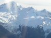
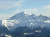
I think this is the answer here that I agree with most. A 1,000' mountain will hurt just as much as a 12,000' mountain if you hit it. I've been based in Colorado for a long time and have flown all kinds of airplanes in the 'real' mountains. I never thought much about the mountains in the east until one day when we did a circling approach into Pittsfield, MA. Those mountains looked really big and really close...Speaking of the eastern mountain range in it's entirety...
I've found that if you're simply flying OVER them enroute then they're far safer than the "real" mountains out west because you can provide yourself with more separation w/o needing oxygen and/or a turbo.
But if you're flying TO them...then that's a whole 'nother story. There are some peak to valley "delta elevations" rivaling some of those in the west and that's what kicks the bumps especially in some of the areas with higher peaks.
I never thought much about the mountains in the east until one day when we did a circling approach into Pittsfield, MA. Those mountains looked really big and really close...
I visit PA often to see my girlfriend, and I want to fly from KZER (Schuylkill County) to KUNV (State College) next time I visit. Is this something I could tackle without training?
I never thought much about the mountains in the east until one day when we did a circling approach into Pittsfield, MA. Those mountains looked really big and really close...
Interesting thread, and great information. I fly the Eastern Ranges, specifically the Catskills, Berkshires, Taconics and Adirondacks, virtually all the time, I agree that while not the Rockies, they require the same level of preparation and respect as any similiar terrain.
I think the Twin Cessna was just a plan on a piece of paper back when this happened.That's jus' 'cause that twin Cessna is way too fast...
Mountains don't have to be super tall to reach up and smite thee. Look at the mountains around Mena, AR - between Rich Mountain, Fourche Mountain and Black Mountain, there's probably 2 dozen crash sites...and they're "only" 2,700 - 2,800 msl.
From a more local perspective....
I flew from N10 just north of Philadelphia to State College for my long solo XC during my training. There are still things to consider, valley fog and ridge winds, but on a typical day wouldn't be anything unusual for a typical pilot.
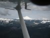
If you have flown northern Jersey and over to the Wilkes Barre area, it is pretty much the same. I prefer to maintain 1000 above the ridge when crossing if winds are 15-20 knots or more.
UNV is a nice airport and friendly FBO.
I didnt figure it would be of much concern, but this trip may be my first time in a 172. The instructor at ZER says there is hardly a difference between it and a P28, but he may have more to say when i tell him i want to do a XC in it. Is this unadvisable?The trip from Zerby to University Park should be a nice one, in a craft with which you are fully familiar.
This will really test my pilotage and DR skills, since the SEG VOR is unusable 10NM after i pass it. As short as this flight is, it should prove to be tougher than it looks.Be ready to find that one valley looks a lot like another; KUNV lies in a valley that looks kinda like the one just south of it - it is easy to descend too soon, then need to climb over the next ridge. If you do, climb well above it (esp if the winds are from NW - like most days).
I suggest crossing at 2000' AGL minimum. even in Pa. the wind over the mountains, (or hills as they are called) if winds aloft are more than 15 knots, can exceed the climb cabability of your plane. (what do you fly?) It can take you by surprise if you are not used to flying in that kind of terrane. better safe than sorry. I trained out of Reading & Allentown PA. before moving to Montana.
Somewhere, sometime, somehow, I was taught that you should clear the peaks by a bare minimum 50% of the "delta elevation change". i.e. if the valleys are at 2000' and the peaks at 7000' then there is a 5000' elevation change and you should clear the peaks by at least 2500' and fly at a minimum altitude of 9500'.
This margin should keep you above any waves created by the moutains on most days.
I like this rule of thumb.
So for PA "mountains:"
The valleys are at 500ft, the peaks are at 1500ft, so you should fly at a minimum elevation of 2000ft.
I can see why that'd be tough
Somewhere, sometime, somehow, I was taught that you should clear the peaks by a bare minimum 50% of the "delta elevation change". i.e. if the valleys are at 2000' and the peaks at 7000' then there is a 5000' elevation change and you should clear the peaks by at least 2500' and fly at a minimum altitude of 9500'.
This margin should keep you above any waves created by the moutains on most days.
Personally, when doing checkouts, I like to focus on the airplane, its flight/handling characteristics, and its systems (including normal and emergency operations and procedures) initially, and later get into other issues like navigation to strange places with new nav gear only when the trainee has the airplane well in hand.I didnt figure it would be of much concern, but this trip may be my first time in a 172.