IR/VR Military Training Routes question

TangoWhiskey

Touchdown! Greaser!
Joined
Feb 23, 2005
Messages
14,210
Location
Midlothian, TX
Display Name

Display name:
3Green
So... According to the current Instrument Flying Handbook, page 8-4 (and this is as I've always understood it):

Routes are identified as IFR (IR) and VFR (VR), followed by a number. MTRs with no segment above 1,500 feet AGL are identified by four number characters (e.g., IR1206, VR1207, etc.). MTRs that include one or more segments above 1,500 feet AGL are identified by three number characters (e.g., IR206, VR207). IFR Low Altitude En Route Charts depict all IR routes and all VR routes that accommodate operations above 1,500 AGL.

A review of En Route Low Altitude chart panels shows that all MTRs and their effective altitudes for the given chart are included on the panel that has the special use airspace and MOAs detail.

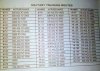
Here it is for L-17... what's with the TWO-digit MTRs? Does it define something other than described above, or do they need to update their description to say that "routes with segments above 1,500 feet AGL are identified by two- or three-number characters"?

attachment.php
 

Attachments

  • L17 MTRs.jpg
    L17 MTRs.jpg
    190.4 KB · Views: 167
Those are the numerical order of assignment for the airway designation. You've heard of Highway 1? Meet Airway 1.

Seriously...those are MTR's in which zeros were dropped, and are usually found in the southern US. The zeros on the front of the MTR designator were dropped. It applies to routes one through 99. Accordingly, rather than have route 001, you see route 01, and rather than 099, you have 99.
 
I last flew IR MTRs in 1997. I do not remember any 2 digit routes. Prior to IR, the were called OB, Olive Branch or "Oil Burner" routes.

All of our routes less than 100 had a leading zero, IR-027, IR-075.

Just remember there are fast movers in those routes. B-52s plan 340GS, B-1s plan 540GS.
Ground speed is used for timing control to maintain spacing in the route structure and ATC planning. So they may be faster to get back on timing. Military aircraft within the IR are MARSA with each other, not talking to ATC except at required reporting points dependent on the route requirements. ATC keeps IFR traffic separated from IR routes when they are "hot".

Not all aircraft within the IR route may be within radar coverage. Route width can vary, but normally are 4nm either side of centerline. Aircraft are not required to maintain centerline but to remain within the route structure.
 
A good point that should be emphasized. I have yet to fly an MTR with anything more than a courtesy call to FSS prior to commencing and another when exiting. Half the time, I never hear anything on the other end. Granted I've got the CATM-9 under the hammer, and a short range radar set pulled up to hopefully find anyone in front of us, but it's still good old fashioned see and avoid, even at 300-500' AGL and 500 KIAS. Not a lot of time for a dedicated lookout.
 
There are quite a few military training routes in Arkansas that are not on the sectionals or IFR Low Altitude charts. Little Rock Air Force Base has a system of C-130 training routes which are not published.
 
There are quite a few military training routes in Arkansas that are not on the sectionals or IFR Low Altitude charts. Little Rock Air Force Base has a system of C-130 training routes which are not published.
C-130's are not flying over 250 knots at low level, and so are not restricted to the LLMTR's (IR's and VR's).
 
Seriously...those are MTR's in which zeros were dropped, and are usually found in the southern US. The zeros on the front of the MTR designator were dropped. It applies to routes one through 99. Accordingly, rather than have route 001, you see route 01, and rather than 099, you have 99.


This answer was the correct one. Heard from AeroNav, they publish the list EXACTLY as they receive it from DOD, and they do drop the leading zeroes.
 
Back
Top