You are using an out of date browser. It may not display this or other websites correctly.
You should upgrade or use an alternative browser.
You should upgrade or use an alternative browser.
Interesting METAR map
- Thread starter tinerj
- Start date
MyassisDragon
Line Up and Wait
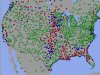
I think many of the RED airports is METAR equipment that is not reporting correctly because of ice.
When I looked at them this morning it was all rain and low overcast (below 1000) in the southern areas.
Curious which ones are you referring to?
tinerj
Cleared for Takeoff
- Joined
- Jul 1, 2012
- Messages
- 1,350
- Display Name
Display name:
tinerj
I noticed in St. Louis on I-44 a MoDot sign warning truckers of "extreme delays in West Memphis on I55." That made me think what I was seeing on the METAR map was due to persistent ice in Arkansas and Mississippi. When the equipment is not functioning, the dot on the METAR is shown as red.
However, after clicking on some of them, the red does appear to be caused by true IFR conditions.
I wonder how "weather proof" the METAR reporting stations are? If there is a severe ice storm, but the next day the weather itself is VFR, with the station be able to report despite the ice?
However, after clicking on some of them, the red does appear to be caused by true IFR conditions.
I wonder how "weather proof" the METAR reporting stations are? If there is a severe ice storm, but the next day the weather itself is VFR, with the station be able to report despite the ice?