Informal Tutorial - San Diego Coastal Route

AcroGimp

Cleared for Takeoff
Joined
Aug 30, 2013
Messages
1,480
Location
San Diego, CA
Display Name

Display name:
AcroGimp
So I finally flew the San Diego Coastal Route - southbound yesterday morning and wanted to share the GoPro for anyone interested in this route - I made a few minor mistakes and left them in to show even after 28 years we can goof things up.

Along the beach you are 500 or below through KSAN's Class B until Point Loma then 800 through NAS North Islands' Class D - great views of the coast and the ocean.


DISCLAIMER - I am not a CFI, I had searched for a good video showing the radio calls and points of interest but most were substantially edited and didn't cover the various elements I wanted to see. This is not intended to be instruction.

Enjoy!

'Gimp
 
AcroGimp - thanks for posting your video! I'm up in Orange County, but flying down your way and doing the "Low Bay Transition" is on my short list.

Where can I read about the 500 foot transition through San Diego's (KSAN) surface segment? Is it on the TAC somewhere?

Thanks!
 
Also, re the chart tucked away in the gap on the upper left of your panel, is that homemade, or available somewhere?

Your video gives a pretty good look at it right around 20:20.
 
The chart is the San Diego Fly Chart, I got it at Marv Golden's (on the airport at Montgomery (KMYF). It shows all of the known VFR corridors and the Coastal route including reporting points and frequencies.

Might be able to get it through Marv's online shop or at a local pilot shop up your way.

I highly recommend the flight, nowhere near as tough as I expected but I went out while the clouds were present but retreating, the airspace can get very busy with banner tows and other VFR traffic when the weather is nicer.

It was a great time and glad you guys enjoyed it/found it helpful.

'Gimp
 
What a great flight. Down the beach over the water is an amazing experience for this landlocked pilot. We flew from Savannah down to Jekyll on our way to SNF about 5 years ago and flying the coast was a real highlight for me.
 
I did my first student cross country from KSNA to KSAN in 1976. Of course the airspace wasn't quite as complicated then but San Diego was a TCA then. There is great scenery flying down the California coastline. It was fun before all the airspace restrictions. Don
 
I ran across another video of a low coastal transition, southbound, through Lindbergh's (KSAN's) bravo:

http://youtu.be/ryDPNdoOsE8

Out of curiosity, one of the comments says:

YouTube Comment said:
Great video!! I've done that route a few times but ever since someone from the FSDO literally fell out of their chair when they heard we were flying 500 ft up the coast, and expressed serious doubt that we would keep our licences if someone reported us, I've stopped doing it. But seeing that video makes me think I should go one more time.... ;) Great stuff.

Given the bolded comments, are there any concerns? I can't imagine that there are given that Lindbergh tower literally requires you to fly at or below 500 feet, but who knows....

Flying off the coast seems pretty clearly to be "over open water." My reading of 91.119(c) is that when flying over open water there are NO altitude restrictions except that the aircraft should not be operated closer than 500 feet to any person, vessel, vehicle, or structure. Simple as that.

So, flying over the water at 400-500 feet, and staying at least 500 feet away from boats, piers, etc., is all good, right?

Also, in this video, The pilot's comments indicate that he flew southbound in the bay at 1000. In the video, while talking to North Island tower, the two planes turn in to San Diego Bay at Point Loma and fly over the bay to Coronado Bridge. Am I correct that over the Bay is an "other than congested area" such that 500 feet is the minimum and 1,000 feet would be just fine?
 
I'd like to know that too, cause this is a flight I'd love to do since it's so close.
 
Back in the day, pre 9/11, we used to be able to come over the sub base at Pt. Loma, and past the carriers, and over the coronado bridge, reporting the blue crane to North Island. Last time i tried that, Island tower told me in no uncertain terms to not overfly the sub base and stay offshore.
 
Back in the day, pre 9/11, we used to be able to come over the sub base at Pt. Loma, and past the carriers, and over the coronado bridge, reporting the blue crane to North Island. Last time i tried that, Island tower told me in no uncertain terms to not overfly the sub base and stay offshore.

It seems that North Island tower will still let you do a "channel" transition or "bay tour" that will eventually take you south of Coronado Bridge, but you need to round Point Loma over the water and not fly over any naval vessels.

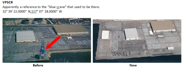
Sadly, it appears that the blue crane is no longer there, even though the GPS waypoint VPSCR was created with the CRane in mind:

VPSCR%20-%20Blue%20Crane.jpg
 
Last edited:
Interesting.. I need to get out and do some flying in vegas now.
 
So I finally flew the San Diego Coastal Route - southbound yesterday morning and wanted to share the GoPro for anyone interested in this route - I made a few minor mistakes and left them in to show even after 28 years we can goof things up.

Along the beach you are 500 or below through KSAN's Class B until Point Loma then 800 through NAS North Islands' Class D - great views of the coast and the ocean.

***

'Gimp

Thanks in part to your post Gimp, I got to fly the San Diego Coastal Route too. I had three weather cancellations, but eventually managed to find a doable day. It was a truly wonderful flight for this new pilot. Thanks for the video.

Here's a video of my flight:

 
Just did this route today northbound riding as a passenger. Also did the Taxiway D transition over KSAN which was pretty cool. Gonna have to do this one a lot more now that I've seen how simple it really is.
 
It seems that North Island tower will still let you do a "channel" transition or "bay tour" that will eventually take you south of Coronado Bridge, but you need to round Point Loma over the water and not fly over any naval vessels.

Last month I was in San Diego and flew this route with a buddy who does it all the time. He handled the radio, but it was very smooth and North Island was friendly. We were told not to overly any naval vessels or piers, but even staying in the middle of the bay all the way to the bridge, we were pretty darn close to fly over 4 or 5 subs and a bunch of other vessels, including the Independence. Flying the taxiway D transition at 1,500' was also very cool.
 
since we're talking about the various different routes, where does one find out about these routes and what the procedures are? My TAC has information about the VFR corridor, but nothing about the Twy D transition, coastal, bay tour, or anything like that. Where do we find the proper procedures and routes for such things?
 
since we're talking about the various different routes, where does one find out about these routes and what the procedures are? My TAC has information about the VFR corridor, but nothing about the Twy D transition, coastal, bay tour, or anything like that. Where do we find the proper procedures and routes for such things?


Honestly, a couple hours of dual with a knowledgeable CFI is a good way to learn. If you're the DIY type, marv golden sells a "chart" with all the sightseeing routes on it.
 
Honestly, a couple hours of dual with a knowledgeable CFI is a good way to learn. If you're the DIY type, marv golden sells a "chart" with all the sightseeing routes on it.

Here's a link to the "chart" I think you're talking about, a laminated chart published by "Scenic Flight Maps."

http://www.aircraftspruce.com/catalog/pspages/scenicMaps.php

13-05667.jpg


I bought one. It was nice to review because it discusses some communication sequencing on the back, but it doesn't show

  • the "Taxiway Delta" transition (usually just "Delta Transition" it seems) that you can use to fly over Lindbergh's taxiway D at 1500 feet.
  • the "bay tour" or a "channel transition" through North Island's airspace. The only transition it shows is offshore and west of the coast.

It seems like there's still some local knowledge that didn't make it onto the "Scenic Tour Chart."
 
I've got that one. The best bet is to still book an hour or 2 of dual with your favorite CFI and really learn it.
 
Thanks for sharing - was nice to see some of the old sights. Used to fly out of Miramar when it was still proper Blue and Gold. Dove Sunset Cliffs on the weekends, worked on and around Pt Loma during the week.
 
I've got that one. The best bet is to still book an hour or 2 of dual with your favorite CFI and really learn it.

Of course that's a great way to learn any area, but what I'm asking about is something a bit more official. A chart, a guide, some kinda notation in an A/FD. I'm totally planning to pick up that little laminated scenic chart next time I'm at MYF, but even that doesn't show a couple routes that seem to be pretty standard. Just seems odd that there isn't anything anywhere explaining this stuff besides videos on youtube. The LA TAC has like 6 different ways to get through the Class B. San Diego has one, and none of the ones mentioned here.

Now that I've flown it myself as a passenger I'm pretty confident as I know the area quite well, but up until witnessing the communications order and timing I wasn't gonna try it on my own.

You may have already seen it, but just in case, here's a pretty good video (with comms) where a flight of two does the low coastal transition southbound to Pt. Loma, flies south above the channel of San Diego Bay to just south of the Coronado Bridge, and finally does a 180 to fly back north over the channel and do the "Delta Transition" over Lindbergh:

http://youtu.be/ryDPNdoOsE8

Some of the communications with North Island tower are missing, but it still offers a pretty good overview of what to expect.

Edit: Doh! Just noticed I posted this before. Sorry...
 
Last edited:
Well I was gettin itchy for some night flight, and also itchy to try out this flight so I got a buddy to hop in the right seat and went to look at the pretty lights tonight. Flew directly down the coast from CRQ, got clearance through the Class B at 500', then rounded Point Loma and followed the bay at 800'. Passed over the bridge then turned around over the south bay and did the Delta transition over KSAN at 1500' before flying back up to CRQ. Gorgeous night and such an awesome flight. That was an hour well spent!
 
Well I was gettin itchy for some night flight, and also itchy to try out this flight so I got a buddy to hop in the right seat and went to look at the pretty lights tonight. Flew directly down the coast from CRQ, got clearance through the Class B at 500', then rounded Point Loma and followed the bay at 800'. Passed over the bridge then turned around over the south bay and did the Delta transition over KSAN at 1500' before flying back up to CRQ. Gorgeous night and such an awesome flight. That was an hour well spent!


Awesome.. There is some amazing flying there.. I kick myself sometimes for moving away
 
Excellent I'm planning to fly this in the future from Northern California. I'll probably fly it with an experienced CFII for my long IFR XC flight during training.
 
Excellent I'm planning to fly this in the future from Northern California. I'll probably fly it with an experienced CFII for my long IFR XC flight during training.


I did MYF -> OAK -> CRQ -> MYF for my long IFR x/c
 
Just FYI, I picked up that little Scenic Chart from aircraft spruce and noticed a couple errors on it. The tower frequency for Brown and the <7000' frequency for SoCal Approach at the upper right are both incorrect. Wondering how long ago that little sheet was put together.
 
Back
Top