azure
Final Approach
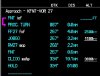
I was shooting approaches at KFNT this afternoon with my finish-up CFII. One of the approaches I did was the VOR 27. This approach has an MDA of 1500 unless you can identify the stepdown fix JOBGO, which allows you to come down to 1260 once inside the fix. I think this is the first time I've flown that particular approach in my airplane, and I noticed that although JOBGO is depicted as a fix on my GMX-200 MFD, and must therefore be in the Jepp nav database for the GMX-200, it is NOT depicted at all on my CNX-80 nor is it shown as a waypoint in the procedure. So I was curious whether it was in the databases for other GPS models like the 430, 530, etc.? Does anyone know?
Which brings me to my main question: do I have any legal way in my airplane to identify JOBGO, since it is not in the CNX-80 database? I do not have DME, and normally rely on the GPS database. Of course I could go to the NRST -> VOR page and use the GPS distance to FNT, but I've never been sure whether that's legal.
Which brings me to my main question: do I have any legal way in my airplane to identify JOBGO, since it is not in the CNX-80 database? I do not have DME, and normally rely on the GPS database. Of course I could go to the NRST -> VOR page and use the GPS distance to FNT, but I've never been sure whether that's legal.
")