I miss NavMonster

JohnAJohnson

Cleared for Takeoff
Joined
Aug 14, 2006
Messages
1,307
Location
Gulf Shores, AL
Display Name

Display name:
JohnAJohnson
Anyone know of a good site that shows weather/weather forecast, TFRs, NOTAMS, etc., along a route?
 
Anyone know of a good site that shows weather/weather forecast, TFRs, NOTAMS, etc., along a route?

I like http://maps.avnwx.com. Enter a route and see all of the METARs/TAFs/PIREPS, along with graphical depictions of TFRs and AIRMET/SIGMETs, and overlay radar if you want. Play with the menus and see all the options you can turn on or off.

It has a NOTAM lookup tool but I've never used it.
 
Anyone know of a good site that shows weather/weather forecast, TFRs, NOTAMS, etc., along a route?

How about LockMart Flight Service? www.afss.com To access, look at the nav bar on the top of the page, and click "Pilot Portal" on the far right.

There has been some significant improvements to the system, including the ability to see the same images in the same sequence the briefer would see. Allows you to follow along with them if you did call in.

Once you sign up with your name, password, profile details, aircraft details, etc., this information is retained not only for web use, but when you call in for a real briefing. The new system will recognize you're calling from a phone number associated with your profile, and pre-fill in the data blocks for the briefer. No longer do you need to say name, tail#, based at, aircraft type, hours fuel, etc., each time you call in.

When you are in the system, and plan a route, the first page you see is the "Adverse Conditions" tab, showing you anything that could be a problem, including TFR's, SIGMETS, AIRMETS, etc. (see thumbnail below).

So that answers your initial question.

Additional new features include ability to open and close flight plans on the website (as in, via the browser on your smart phone if you want). And a new alert feature that will send both a text and an email if something along your route requires your attention (such as an adverse condition).

In summary, the new system is worth investigating to see if how it can fit into your flying routine.
 

Attachments

  • fss.jpg
    fss.jpg
    107.1 KB · Views: 11
  • fss2.jpg
    fss2.jpg
    177.2 KB · Views: 13
I like http://maps.avnwx.com. Enter a route and see all of the METARs/TAFs/PIREPS, along with graphical depictions of TFRs and AIRMET/SIGMETs, and overlay radar if you want. Play with the menus and see all the options you can turn on or off.

It has a NOTAM lookup tool but I've never used it.
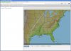
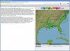
avnwx.com is my go-to for the big picture as well.

The new LockMart site's best value-add is when you are speaking with a briefer. Otherwise, other sites do a better job of data presentation.
 
I'd give my left ball bearing to have NavMonster back. Nothing as good before or since. :sad::(
 
There's also pilotgeek.info. I think it does NOTAMs and TFRs but I can't really remember.
 
I like weathermeister.com. It's a pay site and a little bit 1990s-ish, but I like being able to customize what data is included in the report it generates, and in what order those data are shown.
 
How about LockMart Flight Service? ...

There has been some significant improvements to the system..

I'll say!

I tried it when they first went public and it was all but useless. Now, I can see using it to follow a FSS briefing. It has other values too but is a bit too cumbersome for just getting a quick weather picture.
 
I like weathermeister.com. It's a pay site and a little bit 1990s-ish, but I like being able to customize what data is included in the report it generates, and in what order those data are shown.

Yep, I remember using it when it was free and it does have all the information a guy needs for a XC weather look-see. I probably would have continued with it when it changed to a pay site, but to me, the 1990s user interface didn't warrant it.
 
Back
Top