Huge TFR

labbadabba

Pattern Altitude
Joined
Aug 12, 2014
Messages
2,391
Location
Lawrence, KS
Display Name
labbadabba
Home Airfield
KIXD, KLWC
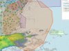
Is this for real or did SkyVector freak out on me?

Looks like the entire Mid-Atlantic coast and well out to sea...
 

Attachments

  • HugeTFR.jpg
    HugeTFR.jpg
    263 KB · Views: 126
It looks real, but not a "normal" tfr
DUE TO REQUIRED MILITARY ACTIVITY ON 1030

!FDC 6/7090 ZDC SPECIAL NOTICE. DUE TO REQUIRED MILITARY ACTIVITY ON 1030/1090 MHZ, THE TCAS SYSTEM AND ADS-B SYSTEM MAY BE LESS SENSITIVE THAN NORMAL IN THE AIRSPACE OVER PORTIONS OF MARYLAND, VIRGINIA AND NORTH CAROLINA WI AN AREA DEFINED AS 37502
 
I don't see a TFR anywhere else. FF doesn't show it either. Did they mistakenly label it as a TFR? Shouldn't it be a NOTAM instead?

Wait, who still uses SV? I thought it went under shortly after they broke the UI.
 
It was on ff for a short while, although it was in yellow since the activation time hadn't happened yet. Doesn't show now.
 
I don't see a TFR anywhere else. FF doesn't show it either. Did they mistakenly label it as a TFR? Shouldn't it be a NOTAM instead?

Wait, who still uses SV? I thought it went under shortly after they broke the UI.

I use it for quick and dirty snapshots and looking at airways.
 
.... well I wish I would have seen this thread before I posted a further hijack elsewhere.

I use Skyvector. It's pretttttttttttttttyyyyyyyyyyy. =D
 
I don't see a TFR anywhere else. FF doesn't show it either. Did they mistakenly label it as a TFR? Shouldn't it be a NOTAM instead?

Wait, who still uses SV? I thought it went under shortly after they broke the UI.
No, it's still alive. I use it for a quick look at routes and current conditions from my desktop, i.e. without having to open my iPad. In fact, I use it for quick weather updates from my computer at work all the time.
 
That's why I'm sticking with FF.
 
Back
Top
