Michael
Pattern Altitude
Does NYC have a terminal area chart, and does it have the Hudson corridor on it? I know, Im being lazy. But does it? and does anyone have one i can look at? they are hard to come by in AZ.
Michael said:Does NYC have a terminal area chart, and does it have the Hudson corridor on it? I know, Im being lazy. But does it? and does anyone have one i can look at? they are hard to come by in AZ.
Skip, that looks like the helicopter chart for the NY TCA (whoops class Bravo). It is very detailed and what I used when I last flew the corridor no radio a couple of years back. Thanks again to whomever it was on the red board who suggested it - what great chart.Skip Miller said:http://www.maptech.com
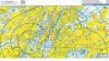
You can view sectionals, topos, street maps at resolutions from 1:50,000 to 1:1,000,000. Attached is a portion of the New York Class B Exclusion, aka the Hudson Corridor.
-Skip
I think you are right that it is the Helo Route Chart. And it was probably me on the Red Board recommending the HRC, I really find it valuable when doing the corridor.Arnold said:Skip, that looks like the helicopter chart for the NY TCA (whoops class Bravo). It is very detailed and what I used when I last flew the corridor no radio a couple of years back. Thanks again to whomever it was on the red board who suggested it - what great chart.
wow. perhaps i should film my flight thru the corridor and sell it online for 29 bucks too!Steve said:There's a video out on flying the corridor...if we're talking the same corridor here...
http://www.dsflight.com/ny_vfr_corridor.html
")
Michael said:wow. perhaps i should film my flight thru the corridor and sell it online for 29 bucks too!
come to think of it, i think ill start fiming all my flights and start selling them on ebay.
series 1...how to climb safely thru 1200 ft.
series 2...how to fly over the mohave desert
series 3...how to land in las vegas
sorry steve, that was helpful. thanks