How to find true north during the day (without a compass)

TangoWhiskey

Touchdown! Greaser!
Joined
Feb 23, 2005
Messages
14,210
Location
Midlothian, TX
Display Name

Display name:
3Green
OK, most of us know how to find true north at night using the Big Dipper and Polaris, but if you needed to find true north during the day, how would you do it?

My daughter sent me this information... think it would work? For survival skills, it might be a good trick in your bag...

The Shadow-Tip Method

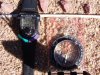
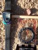
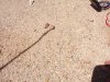
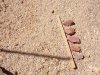
1. Place a straight stick straight upright in the ground so that you can see its shadow. Alternatively, you can use the shadow of a fixed object that is perpendicular to the ground. Nearly any object will work, but the taller the object is, the easier it will be to see the movement of its shadow, and the narrower the tip of the object is, the more accurate the reading will be. Make sure the shadow is cast on a level, brush-free spot.
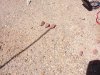
2. Mark the tip of the shadow with a small object, such as a pebble, or a distinct scratch in the ground. Try to make the mark as small as possible so as to pinpoint the shadow's tip, but make sure you can identify the mark later.
3. Wait 10-15 minutes. The shadow will move approximately from west to east in an arc which depends on your latitude and the season.
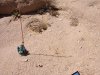
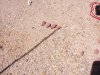
4. Mark the new position of the shadow's tip with another small object or scratch. It will likely move only a short distance.
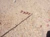
5. Draw a straight line in the ground between the two marks. This is an east-west line.
6. Stand with the first mark (west) on your left, and the other (east) on your right. You are now facing approximately toward true north. (Accuracy improves as your location approaches the equator, and as the time of year approaches either equinox.)
 
Works. We used to teach this technique to Boy Scouts. That assumed, however, that they could sit still long enough to wait the 10-15 minutes. :D
 
Troy Whistman said:
think it would work?

Theories are cute HOWEVER theories mean exactly squat in the real world.
It's hands on practical scientific experiment day!

1. Proper scientific reality sampling device (aka a stick in a vice)
2. Time = 0
3-6. Rocks placed at 5 minute intervals
7. Don't move the rocks. Just need to connect the rocks for the W/E line.
8. End results. Looks like about +-3deg which is well within fudge factor limits.

Note: The compass has a magnetic variation bezel that is offset to 11.5deg which is approximate local magnetic variation. The compass rose is true, not magnetic

Yep. It works.

Now go get lost..but don't forget your stick. ;)
 

Attachments

  • IM004062.JPG
    IM004062.JPG
    63.6 KB · Views: 31
  • IM004064.JPG
    IM004064.JPG
    66 KB · Views: 25
  • IM004065.JPG
    IM004065.JPG
    66 KB · Views: 22
  • IM004066.JPG
    IM004066.JPG
    66.2 KB · Views: 20
  • IM004067.JPG
    IM004067.JPG
    65.8 KB · Views: 21
  • IM004068.JPG
    IM004068.JPG
    65.6 KB · Views: 17
  • IM004070.JPG
    IM004070.JPG
    66.7 KB · Views: 26
  • IM004072.JPG
    IM004072.JPG
    69.4 KB · Views: 36
Last edited:
fgcason said:
...
Yep. It works.

Now go get lost..but don't forget your stick. ;)
I refuse to believe it until Lance explains WHY it works.
 
fgcason said:
Theories are cute HOWEVER theories mean exactly squat in the real world.
It's hands on practical scientific experiment day!

1. Proper scientific reality sampling device (aka a stick in a vice)
2. Time = 0
3-6. Rocks placed at 5 minute intervals
7. Don't move the rocks. Just need to connect the rocks for the W/E line.
8. End results. Looks like about +-3deg which is well within fudge factor limits.

Note: The compass has a magnetic variation bezel that is offset to 11.5deg which is approximate local magnetic variation. The compass rose is true, not magnetic

Yep. It works.

Now go get lost..but don't forget your stick. ;)

Thanks for the pictures and proof! My daughter thought your pictures were amazing (as did I!).
 
Troy Whistman said:
Thanks for the pictures and proof! My daughter thought your pictures were amazing (as did I!).

:) You're welcome. This thread made my day. I needed a project and it was fun. I haven't done that in a long time.

Now, Part 2: Can she determine your latitude with it. (if she turns into smartypants, tell her to figure out out to do relative latitude)

Extra credit: See if she can figure out how to measure the diameter of the Earth with one of those and a little math/geometry.

smigaldi said:
How do I do that if my whiskey compass looses all the fluid while in flight?

Bypass the problem. Solar compass:
http://www.blm.gov/cadastral/Tools/Multimedia/Solar_Compass/solar_compass.html
You can build a very primitive one fairly easily that will reliably get you back to a point where you can get yourself somewhere safe.
 
Good job on the pictures! Now I'm off to play with sticks in the dirt...
 
fgcason said:
:) You're welcome. This thread made my day. I needed a project and it was fun. I haven't done that in a long time.

Now, Part 2: Can she determine your latitude with it. (if she turns into smartypants, tell her to figure out out to do relative latitude)

Extra credit: See if she can figure out how to measure the diameter of the Earth with one of those and a little math/geometry.

Wouldn't it require some trig? She's not up for that level of math yet! ;-) I think she'd be interested in the answers, though! I know I would be!
 
Last edited:
Troy Whistman said:
Wouldn't it require some trig? She's not up for that level of math yet! ;-) I think she'd be interested in the answers, though! I know I would be!

Latitude is dirt simple. The stick is a right triangle. Just need a string and rock to make the stick vertical, protractor or equivalent for angles and know how far N/S the sun is in relation to the equator then measure the shadow angle from the right triangle. (No pictures but I just went out and did that too with the same setup as yesterday - cheap and dirty 2 second measurement showed 41°N, sectional shows 38°52'. Close enough for not trying hard)

Longitude and diameter of the earth is a bit more complicated and uses geometry, some trig, knowing what time it is, sun angle change over time and a drive of about 60 miles. It's all about shadow lengths and time of day. The longer the stick, the better. (And as a third side effect of the measurements, it shows that the earth really is not flat)

mikea said:
That's asuuming that you know which direction you want to go. I guess I'd figure that if I go far enough south at the least the weather will be warmer. :rolleyes:

Ideally the cheapo version in the front window of the plane is for working out an emergency return heading to take you to a known position that you can turn a known direction and go for land if you're flying over somewhere extremely hostile...like the Arctic Ocean. (don't ask why)


Fun stuff isn't it?
 
smigaldi said:
How do I do that if my whiskey compass looses all the fluid while in flight?
Unless all the fluid drained into your gps and shorted it out, I don't see a problem.:D
 
jkaduk said:
Unless all the fluid drained into your gps and shorted it out, I don't see a problem.:D

:eek: :eek: :hairraise: What's wrong with you? Go wash your mouth out with turpentine. This thread is about sticks, not evil unreliable witchcraft. :D

If I snap my stick in half, I can still find my way out of the forest with it. I have yet to see a GPS that can be snapped in half and still function.

Besides, the last time I had a GPS in my hand wandering through the forest at night with no moon, I got so flippin lost I couldn't figure out which way was up. I turned the silly thing off, reoriented myself by starlight, took a look at the terrain around me and a mile later I was standing right where I wanted to go.
 
fgcason said:
reoriented myself by starlight,
Gawd, ain't Nature wonderful that way!

I really do feel sorry for folks who cannot, on a clear night, find their way by starlight.
 
Bummer. The sun is slowly sinking on the WESTERN horizon, and dangit, I can't figure out which way is north...

Btw, common knowledge I'm sure, but as the sun sinks, you can estimate how long before the sun sets and the really scary things come out by holding your hand out and measuring how many finger-widths the sun is above the horizon. Each finger is roughly fifteen minutes.
 
naughtius said:
This only works around noon.

That's an interesting theory. It's wrong. But it's still an interesting theory.

Practical scientific experiment day #2:

1. 10:20 09-19-06
2. 13:58 09-17-06 (from original sequence - see post#3)
3. 17:26 09-19-06

Same setup as before.
5 stones @ 5 minute intervals = 20 minutes.
#1/#2 same location.
#3 was done 20ft from #1/#2 with a slightly shorter stick to keep the shadow length reasonable. (read as: I needed a dowel for a project this afternoon so I cut several inches off the end of the stick)

Results:
The further away from noon, the longer the shadow and spacing between the rocks.
All 3 compass readings are within a few degrees of each other including the slop error of the person (me) putting the stones at the end of the shadow.


BTW: This method will work with the moon...so if you're lost at night and can't sort out the stars (shame shame shame) and have a shadow casting moon, get out your stick and pebbles. If you're really lost and desperate, with a little creativity you can select a star on a moonless night and do the same thing but the error is likely to be greater since you have to eyeball the star and stick.
 

Attachments

  • TN1020.jpg
    TN1020.jpg
    83 KB · Views: 4
  • TN1358.JPG
    TN1358.JPG
    69.4 KB · Views: 3
  • TN1726.jpg
    TN1726.jpg
    82.2 KB · Views: 4
Last edited:
My correction: It only works around noon, or around equinox, like these several weeks. In general the shadow tip moves in a hyperbola through the day and its shape varies with season. You can experiment again on a winter day to see what happens.

BTW, I remember there is something called "Viking Sun Compass", which can actually show you the multiple shadow tip curves.

fgcason said:
That's an interesting theory. It's wrong. But it's still an interesting theory.

Practical scientific experiment day #2:

1. 10:20 09-19-06
2. 13:58 09-17-06 (from original sequence - see post#3)
3. 17:26 09-19-06

Same setup as before.
5 stones @ 5 minute intervals = 20 minutes.
#1/#2 same location.
#3 was done 20ft from #1/#2 with a slightly shorter stick to keep the shadow length reasonable. (read as: I needed a dowel for a project this afternoon so I cut several inches off the end of the stick)

Results:
The further away from noon, the longer the shadow and spacing between the rocks.
All 3 compass readings are within a few degrees of each other including the slop error of the person (me) putting the stones at the end of the shadow.


BTW: This method will work with the moon...so if you're lost at night and can't sort out the stars (shame shame shame) and have a shadow casting moon, get out your stick and pebbles. If you're really lost and desperate, with a little creativity you can select a star on a moonless night and do the same thing but the error is likely to be greater since you have to eyeball the star and stick.
 
Last edited by a moderator:
fgcason said:
:eek: :eek: :hairraise: What's wrong with you? Go wash your mouth out with turpentine. This thread is about sticks, not evil unreliable witchcraft. :D
I kind of think this thread is about tools you can use to find your way. As aviators we are aware that any of our tools can break, so we always have spares.
 
Back
Top