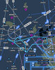
Here’s the current synoptic picture. I’m in SE Tennessee and as you can see, there’s high pressure right over us, yet it’s solid overcast all across the region with a ~2000ft ceiling. What gives?

Dunno, guess I’ve always been under the impression that high pressure dries everything up. Color me ignorant!Where does it say that a high pressure can’t be overcast?
Makes sense. Must be moisture getting pulled in from that stationary front around the gulf coast.Exactly as MS noted. High pressures tend to be good VFR weather, but if there is enough moisture pulled in, you’ll get clouds. Happened to me around NYE last year when I was stuck staring at ice bomb clouds for 3 days straight and it was a high pressure the whole time.
Here’s the current synoptic picture. I’m in SE Tennessee and as you can see, there’s high pressure right over us, yet it’s solid overcast all across the region with a ~2000ft ceiling. What gives?
View attachment 108567
Here’s the current synoptic picture. I’m in SE Tennessee and as you can see, there’s high pressure right over us, yet it’s solid overcast all across the region with a ~2000ft ceiling. What gives?
View attachment 108567
I came out of my PPL also thinking the high pressure days will be the best days with no exceptions. Learned the following summer that weird stuff really happens during some of the high pressure areas. To me the weirdest one is that its literally CAVU for 100 miles in any direction. But then right at our destination clouds form and it starts raining. And I just had a more signficatn thing happen up here in MN/SD on Saturday. The wind was even up to about 7kts, enough to make the wind turbines turn. And well after noon, temps in the mid 80's, winds about 7kts we had ceilings as low as 800ft with few at 300ft. I did some over the top and thankfully our home base was wide open. But our destination wasn't so we had to divert. Maybe its worst where you are but this was 100miles wide for an entire day. It was a case where humidity had dropped the night before, wind slowly switched to SE and must have been just the right amount if moisture pumping in to main OVC all day but not rain. Here's a shot where it just opened up for about 15 miles. All the rest was solid OVC. Its hard to tell in the picture but several of them are in the low clouds and turning.Here’s the current synoptic picture. I’m in SE Tennessee and as you can see, there’s high pressure right over us, yet it’s solid overcast all across the region with a ~2000ft ceiling. What gives?
View attachment 108567