jconway2002
Pre-takeoff checklist
Hello,
My instructor has tasked me with planning my first dual cross country. We are flying from KCRQ (Palomar) to L35 (Big Bear).
I initially drew a direct line from KCRQ to L35, but realized the mountains around L35 were quite high. I am wondering how I should handle flying into Big Bear?
As you can see in the attachment, which is a screen capture from skyvector.com, I have the direct route, and than I have a route I drew to avoid the highest mountain peaks, fly to a street pattern, and then go straight in for a landing. Am I doing this right? Anyone have better suggestions?
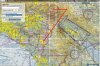
")
