Help me plan this bucket list trip -- flying the Lewis & Clark trail

Van Johnston

Pattern Altitude
PoA Supporter
Joined
Oct 31, 2012
Messages
1,801
Location
South Texas
Display Name
Van Johnston
Route is in the title of the post. If your US history is rusty, here is a more detailed depiction. Start near St Louis and end at Astoria OR.

Looking for specific recommendations on places to stop, either for mid-day fuel/food, or overnight.

I've been planning this post-retirement trip for five years. Purely a sight-seeing trip for the geography, geology, and history. I have no requirement to be at any place at any time. General plan is two 2-3 hour legs a day, 1-2k AGL, day VFR in an AA-5B. Will take every 3rd or 4th day off if weather hasn't already imposed a day off. Estimated departure is 9/22/25.

I've read Domenick's blog about his long trips and watched Birdus' videos of his trip flight part way down the Missouri River and gleaned lots of good info from both.
 
On your return trip I'd consider a day in Jackson, WY (KJAC) and one in Rapic City, SD (KRAP) and go see Mt Rushmore and Crazy Horse Memorials. How often are you going to be flying out in these areas?

For JAC, I can find out if there are rental cars in Driggs, ID (KDIJ) which is a lot more GA friendly. But it is on the other side of the mountains, so there is some drive time there. When leaving if you leave there is a Pass that can get you over that section of the Rockies. The FBO at JAC was always nice, but the airport imposed some fees and their may be FBO fees as well. So call ahead to see what they may charge for an overnight.

And keep us posted on when you're thinking of going. Sept/Oct can be some great flying Wx and the winds are usually not as strong.
 
Route is in the title of the post. If your US history is rusty, here is a more detailed depiction. Start near St Louis and end at Astoria OR.

Looking for specific recommendations on places to stop, either for mid-day fuel/food, or overnight.

I've been planning this post-retirement trip for five years. Purely a sight-seeing trip for the geography, geology, and history. I have no requirement to be at any place at any time. General plan is two 2-3 hour legs a day, 1-2k AGL, day VFR in an AA-5B. Will take every 3rd or 4th day off if weather hasn't already imposed a day off. Estimated departure is 9/22/25.

I've read Domenick's blog about his long trips and watched Birdus' videos of his trip flight part way down the Missouri River and gleaned lots of good info from both.
Lotsa geography, geology and history on that route. I know the end part of it very well, I was raised in Portland. Here’s some links. The WAAAM besides having planes is full of history. It’s not one to do in just a couple hours. There is the Columbia River Gorge. Google it. Mount St. Helens. Page 339 of the Northwest Chart Supplement has recommendations for flying around it. And of course, Fort Clatsop.
 
I'll only comment on the parts I know best.

Y27 is pretty desolate. I got my ND passport stamp there, nothing else.

Y19 is a great fuel stop. There is a courtesy car that you can take to Fort Abraham Lincoln State Park. I'm not sure about the courtesy car situation at 5C8 but it is the closest airport to both the actual Fort Mandan (winter home of the Corps of Discovery 1804-1805) and to the modern replica of it.

If you don't mind gravel, 37N is a really cool little airstrip, parallel to and on the bottom side of the Garrison Dam. But there's nothing there so your D05 fuel stop is a lot more sane.

9Y1 has a courtesy car and you could visit the Killdeer Mountain Battlefield from some 60 years after the Lewis and Clark Expedition.

S25 is the nearest courtesy car to the Lewis and Clark Trail Museum, although I've never been in the museum so I don't know if it's worth a stop or not. I'll report back if I get there before your trip.

KXWA competes with KDEN for "longest drive from airport to town." It's a pleasant enough airport but you're right to bypass it.

37S might be okay in late September but I'm not sure. I've never landed there, just driven past it a few times. The grass looks nice but it feels more like a neighborhood than an airport. I'd aim for KGGW instead, and take the courtesy car into town to have a steak at Durum. This is what a small town steakhouse should be. (Check hours beforehand, because I think they are closed on Mondays and any other day I send someone there for a steak.) It's also a great place to pick up some supplies like airplane oil in sales tax-free Big Sky Country.

If you run into problems anywhere between about KPIR and KGGW or so, let me know. I can probably get you in touch with someone who knows the right guy to fix the problem for you.

I don't know if it would end up being helpful or not, but there are some mountain flying instructors based at KBZN. That would be a fun place to stop, get some local flying in, and head into the Rockies with that local skillset in your toolbox in case you need it the following couple of days.

I second the suggestion of a return trip that hits some off-trail hotspots. Even the original adventurers split up on the return trip to do more sightseeing.

How closely does the Rocky Mountains portion of your route follow the Corps of Discovery route? It looks very intentional but I don't know enough about the expedition to tell if you're following their Journal or the sectional MEFs. :)
 
I have very little experience in that part of the country so I have nothing to add as an answer to your question
but I'm reminded of an instructor at the flight school where I trained years ago in Williamsburg. A really nice guy, former USAF pilot. His primary business was an air tour company that he founded. He apparently was quite the historian. As I recall, he grew up in that area and had a strong interest in the history. Maybe he studied it in college, I'm not sure. I went with him once on a tour, and it was a very nice tour! I think what made it was his narration... based on knowing the places and the stories as we flew over...kind of like looking at a map while learning about the events, but more than that. It was a neat way to look at places and geography.

My point is that I'd imagine such a trip will be better when you can really look at the places were specific stories happened..when you know the events in great detail. Something that I'd imagine with your interest in doing this trip that you have a strong foundation in the events and sories. I'd guess that the best thing you could do to prepare is to double down on that knowledge and let that steer you to the places to go and how much time you spend in each area
 
How closely does the Rocky Mountains portion of your route follow the Corps of Discovery route? It looks very intentional but I don't know enough about the expedition to tell if you're following their Journal or the sectional MEFs. :)

Thanks for the recommendations.

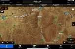
I've spent the most time researching and planning the overland route. I'm relying mostly on a book called The Trail Between the Rivers, written by an engineer who tried to correlate Clark's hand drawn maps to USGS map segments, and then collaborated with a historian/hiker who hiked the entirety to try to verify ground truth. Both are local to western Montana. The author admits there are portions where it is impossible to determine the exact trail, but I figure from 2k AGL the path will be somewhere in my field of view. Here are the way points I came up with for the overland portion based on the book:
 

Attachments

  • IMG_1940.PNG
    IMG_1940.PNG
    4.6 MB · Views: 24
My point is that I'd imagine such a trip will be better when you can really look at the places were specific stories happened..when you know the events in great detail. Something that I'd imagine with your interest in doing this trip that you have a strong foundation in the events and sories. I'd guess that the best thing you could do to prepare is to double down on that knowledge and let that steer you to the places to go and how much time you spend in each area

Agree. I've been wading through L&C's actual journal(s).
 
I keep my plane at your starting point.

I’ve thought about a similar adventure so I’m looking forward to reading about your journey.
 
About 25 years ago I rode the route on motorcycles with my old man and brother-in-law. Great fun. We'd actually started in Washington DC (really Bethesda, MD), then went down to Kitty Hawk, to make it a full coast-to-coast ride. Picked up the Lewis and Clark trail on the way, Almost entirely on 2-lanes, but for a bit along the Columbia, and a few other places. Be advised the Columbia Gorge can be windy.

"Ocean in view. Oh, the joy!"

Have a GREAT time!
 
Missed this thread earlier. If not too late, highly recommend a stop in Winifred(9S7). It's more or less the heart of the Missouri river breaks, and has fuel and one of the more remarkable pilot's lounges I've seen(in a good way). Hotel a couple blocks away if needed. They were working on the runway this year, not sure if it's complete or not yet but no NOTAMs at the moment. Could be worth a call to check.
On the way there westbound, if your aircraft is capable and the conditions are right a stop at the grass strip at Heller Farm(L51) is very neat. Right on the Missouri, could have a very Lewis and Clark experience. Caution as it may not be mowed and I'd avoid it if the grass is long.
From there head to the confluence of the Missouri and Judith rivers and fly low level down the Judith to Lewistown. Safe travels!
 
On the way there westbound, if your aircraft is capable and the conditions are right a stop at the grass strip at Heller Farm(L51) is very neat. Right on the Missouri, could have a very Lewis and Clark experience. Caution as it may not be mowed and I'd avoid it if the grass is long.

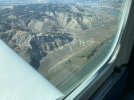
I flew over it about 2 hours before you posted. I considered it. I knew about it from a video another POAer made that landed there. I would have done it if not so isolated. (“If you need help, there’s a motorcycle in the shed you can take to a gas station about 20 mi away,” or wait for kayakers to come down the river). Didn’t want to risk being stranded. IMG_3249.jpeg
 
Back
Top