Haze over Martha's Vineyard

Michele

Pre-Flight
Joined
Nov 29, 2009
Messages
96
Location
New York
Display Name

Display name:
Michele
Hiya,

Been researching a trip to MVY and found just what I'm looking for in 1B2, Katama. My concern is the distance over water and the haze.

My vfr route will be direct from KHPN. I'm thinking of a little rerouting to cross over Buzzards Bay instead of the longer water crossing over Rhode Island Sound. The other thing is the haze. I've experienced haze over water when crossing the Long Island Sound from Montauk (MTP) to CT and it wasn't fun. :yikes:

For those of you who frequent the Vineyard, what approach do you fly that minimizes the water crossing and what can you say about the haze of late?

Thanks
 
Last edited:
I've flown twice from Nashua (ASH) to MVY direct. This direct route takes you over Buzzard's Bay. On both flights there was good visibility - well over 10 sm - and I could clearly see land on both sides of Buzzard's Bay. The bay is full of boats and I also had a fair amount of altitude and flight following, I had no concerns about making the over water crossing this way. If you plan to intercept the 313 Radial of MVY VOR at COSSY intersection your overwater distance will be limited to 9 nm. That routing adds very little to your route from POU. Use flight following, use the VOR, make good use of the tools you have and I think you will not have a problem.

Caveat, I would be much more cautious about attempting it at night.

Thanks for the advice. I read all intently, thinking "Thank-You's" and making mental notes, then the last line made me laugh out loud...err, don't think I'll be making any over water night flights any time soon :no:, but I like that you think I might have thunk it :wink2:
 
This route is probably better over water at night than the alternatives but that doesn't make it smart! Maybe with a completely full moon and very clear skies. The Islands - ACK especially - have a tendency to get fog and low clouds at night/morning times which further complicates things.

I've never been to Katama, only MVY, but it is on the list. Supposedly a great first grass strip with the longest runway at 4000 feet and well packed.
 
Caveat, I would be much more cautious about attempting it at night.

JFK, Jr. (RIP)

The same issues can happen in the open midwest at night or in the SW desert.
Not the fog, but the loss of a discernible horizon.
 
You can hug the RI coast and then cut over cuttyhunk and there won't be too much open water to contend with. If its too hazy land on the mainland side or turn around. plan your flights so that if there is haze the sun won't aggravate it even more.
 
VFR, I plan direct KEWB, then direct KMVY, 1B2, or KACK depending on where I'm landing. IFR, I have little choice and usually get sent way south overwater (NEWBE or DEEPO intersection). At night, I prefer to go IFR unless it is absolutely gorgeous and I have an autopilot or a second pilot in the right seat.

Katama is in good shape and a fun place to visit. In terms of haze, fortunately the Vineyard is usually in better shape than Nantucket when it comes to weather (usually, but not always). I have seen days where both are down at minimums, below minimums, or CAVU. Quite often when Nantucket is reporting 1800 RVR, MVY will be MVFR or CAVU. Very weird weather out there, lots of rolling fog banks that come in and go out. Having outs where you can divert to on mainland is essential (EWB, HYA, PVD, etc).

Mid morning after the fog burns off til early afternoon is usually the best time to fly there. Morning fog can be persistent and not burn off until as late as 9 or 10am. On the other end, it can start forming as early as 6pm or so or stay good VFR for the entire evening. Fairly strong winds discourage fog formation and tend to keep the area more clear.
 
Last edited:
You can hug the RI coast and then cut over cuttyhunk and there won't be too much open water to contend with. If its too hazy land on the mainland side or turn around. plan your flights so that if there is haze the sun won't aggravate it even more.

Watch for banner towing ops and other such along the CT, RI, and MA beaches.
 
Wow! Thank you to everyone for the great tips. I plan to use flight following and arrive 1B2 about 11ish (time for morning fog to burn off, if any) and leave around 4ish (before sun is too low); EWB and WST are my alternatives. I'll probably go direct to UUU and direct to 1B2 over Cuttyhunk to minimize water flight and avoid overflying MVY.

Here's another question. I've been trying to call the FBO at 1B2 and haven't gotten them yet. On Satellite maps of the runways for 1B2, it appears that Runway-21 (the longest runway next to the road) has two "runways" near the threshold--almost like a runway 21R and 21L that converge half way down the runway. What is going on with that, which (21R or 21L) is for landing?
 
Last edited:
Wow! Thank you to everyone for the great tips. I plan to use flight following and arrive 1B2 about 11ish (time for morning fog to burn off, if any) and leave around 4ish (before sun is too low); EWB and WST are my alternatives. I'll probably go direct to UUU and direct to 1B2 over Cuttyhunk to minimize water flight and avoid overflying MVY.

Here's another question. I've been trying to call the FBO at 1B2 and haven't gotten them yet. On Satellite maps of the runways for 1B2, it appears that Runway-21 (the longest runway next to the road) has two "runways" near the threshold--almost like a runway 21R and 21L that converge half way down the runway. What is going on with that, which (21R or 21L) is for landing?

You can see the threshold markings on the runway - looks like a taxiway on the inside of the triangle.
 
You can see the threshold markings on the runway - looks like a taxiway on the inside of the triangle.

From a close-up satellite image of 1B2, the runways are marked in white and Runway 21-3 has a white "X" above each threshold. I thought the "X" meant closed runway. I know for a fact that 21-3 is open, so what does the "X" mean here?
 
From a close-up satellite image of 1B2, the runways are marked in white and Runway 21-3 has a white "X" above each threshold. I thought the "X" meant closed runway. I know for a fact that 21-3 is open, so what does the "X" mean here?

They were likely closed at the time the satellite image was taken.
 
If you feel uncomfortable on your approach to Katama you can always just pop over to MVY and get the bus back to Edgartown.
 
Thanks, I'll let you know how it goes. :)
Yesterday was a fabulous flying day to make the 153nm from POU to 1B2. To avoid morning fog at the destination, we were airborne at 11am. With flight following, we flew direct to KUUU and then direct to 1B2; owing to a slight headwind, the 1hr30min flight took 1h45m. At 7,500 we flew above the scattered layer, avoided the 90* ground heat and had clear smooth air. It was a great flight in every way.

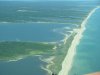
At KUUU, we turned about 20* South and headed across the Rhode Island Sound towards the clearly visible Cutty Hunk and Martha's Vineyard. It was nothing like I'd feared, visibility was so great, I could see Nantucket beyond the Vineyard. And the glide distance between land masses was in our capacity should "something" necessitate gliding.

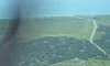
The Vineyard was friendly as it repeated their instructions to stay at 1,000' South of the shoreline to Katama. Just after passing KMVY, I spotted the easily recognizable Katama; triangle shaped boarded by roads. And, it was busy. There were dozens of planes parked and there were at least three of us already in or like me, headed to the pattern. I would be number two behind the Baron with the lady pilot.

It was a spectacularly easy approach. Winds were calm, the wind sock dejectedly aimed at the dirt, runway-21 was the active. Runway-21 is almost at a 90-degree angle to the coast that I'd been instructed to hug. Flying past the airfield in order to set up for the left downwind entry I could check it all out; the other traffic, the field condition, the wind sock, the field activity. I slowed down to give the Baron time to do it's thing and enjoyed scanning the magnificent sky for traffic, birds and whatnot. It was just beautiful.

Finally, the Baron was on short final and I turned left base. I was close to the airfield so base was short and I was high. Watching the landed Baron taxi towards the first turnoff, I turned final, dumped in all the flaps and slipped it to the runway.

This was going to be my first grass landing without a CFI. Runway 21 is 3,700' and clearly marked, as are all three of their runways, with a white threshold line and the numbers. Time slowed way down as I crossed, what seemed like just yards, above some huge vacation castle, cut power and floated over the numbers, added a touch of power to keep from clunking, flared, looked down the runway, held the yoke and YEEEES, kissed the grass, with yoke to my heart rolled effortlessly over smoothness and, like the Baron, made the first turnoff. A wonderful flight, a wonderful first grass landing and a most delightful airpark...but that's another thread.

Thanks everyone for your help. :cheerswine:
 

Attachments

  • Final for R-21 Katama 7-31-11.JPG
    Final for R-21 Katama 7-31-11.JPG
    462.3 KB · Views: 26
  • Approach to Katama 7-31-11.JPG
    Approach to Katama 7-31-11.JPG
    1.9 MB · Views: 27
Last edited:
I just saw an article on this very topic in the 2011 Operations Guide of IFR magazine. Aparently author commutes and has a number of strategies for getting in and out of the area. There is no digital version of the magazine. Article is Filing for Fog Island by Rob McGovern. You might be able to get a copy from IFR.Magazine.com
 
Katama is one of the few grass strips that would benefit from a taxiway diagram! It can be easy to get confused when taxiing and the tall grass doesn't help. The first time I flew in I brought a print out of a google satellite photo of the strip. Can't wait to make it back up that way!
 
Back
Top