Great IFR flight

tonycondon

Gastons CRO (Chief Dinner Reservation Officer)
Joined
Mar 9, 2005
Messages
15,454
Location
Wichita, KS
Display Name

Display name:
Tony
Went up with a student this afternoon, got 2 hours of actual, 3 approaches, 2 VOR and one ILS. We were between layers in IMC most of the trip, at 3 or 4000 enroute. Check out our track on flightaware, N99930. We were originally planning to go to Webster City from Marshalltown, then changed mind which is why we turned back to the south after heading northwest.

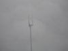
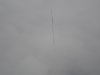
Saw a cool sight on the way back to Ames, we were getting vectored for the ILS to 01 and were coming down on the east side of the airport at 4000 feet. I knew that the TV towers between Ames and Des Moines would be coming up so me and my student had our eyes out for them. Pretty soon they showed up and looked a lot closer than they were. We were 1000 feet above them and maybe 1 mile to the side. It was really cool to see them poking out the tops of the clouds.
 

Attachments

  • DSC00806.JPG
    DSC00806.JPG
    1.9 MB · Views: 57
  • DSC00809.JPG
    DSC00809.JPG
    1.7 MB · Views: 40
Ummm... me too? Just a little.

But Tony, that first tower pic sure looks like an "under," instead of an "over."

Towers give me the willies, big-time.
 
ya spike, that picture does not do it justice. the clouds were a lot whiter and tower was a lot oranger. got my attention at first glance
 
Man, I wish I could have gotten up today. It was a great day for getting some actual, and it looked like DBQ was down pretty low. 400 feet one of the times I checked. And I need I think 2 more approaches in the next couple of months to keep my currency.

Alas, I had to work, and couldn't do anything but drive w/in 2 miles of the airport and sigh. :(
 
Man, I need to get my IR. That looks pretty dang fun.

edit: man, thats a lot of guywires.
 
Got 5.3 in yesterday with three instrument approaches. Left at 6:30am from DPA, into the clouds at 1,200 ASL (500 AGL), came through the top of this layer at about 2,200 - flew between layers with occasional reduced visibility due to rain, then the ILS into KUES (Waukesha County) - into the cloud about 2,800 ASL, broke out about 1,000 AGL. Picked up the patient and her husband (this was a Lifeline flight), filed for KMQJ (Mt. Comfort, IN) and off by 8:15 am. Back into the cloud at about 1,500 AGL and got routed RFD-KELSI-EON to get around O'Hare IFR traffic. Climbed to 6,000 and was between layers but about 500' below the base of the upper layer. Came down to 5,000 when we made the corner towards IN rather than go up to 7,000 which would have put us in the layer. About 50 nm north of KMQJ the top layer disappeared to show a brilliant blue sky but it was a solid deck below. Got the ILS 25 to a circle approach to Rwy 7 - broke out about 800 AGL. The previous plane had advised flying a right pattern to Rwy 7 and so I did the same but in retrospect should have done a left hand pattern. Stayed too close to runway and ended up overshooting the final when turning base and had to turn back in to get lined up. Landed about 10:40 CDT (11:40 local), passed off the patients to the next pilot, refiled back to KDPA and was off about 11:00 CDT. Climbed through the deck and was soon cruising direct JOT at 6,000. Conditions were steadily deteriorating as I got closer - about 100nm out into what would turn out to be relatively steady rain. Unfortunately KDPA has closed Rwy 10-28 for repairs and was using Rwy 2L even though the wind was 100 @ 12-18 reported. Was given the ILS 2L and while still not even established was told to slow to 90 kts or less for the entire approach for spacing. Broke out about 800AGL but didn't see the runway in front of the plane - there it was off to the left. Immediate thought was that if that was the correction angle for the crosswind it was going to be one h*ll of a landing! Got the plane slipping to the left to keep in line with the runway but even with the left rudder right to the floor I could not get the plane straightened out with the runway (kept pressing harder with the left foot in the illogical thought it would help). Was praying the wind dropped a bit at ground level. It did and managed to get the plane pretty well straightened out during the flare, even if I was drifting slightly to the left. On the ground at 12:30. Back in time for the football!
 
Last edited:
bstratt said:
Got 5.3 in yesterday with three instrument approaches.
[...]
Unfortunately KDPA has closed Rwy 10-28 for repairs and was using Rwy 2L even though the wind was 100 @ 12-18 reported. Was given the ILS 2L and while still not even established was told to slow to 90 kts or less for the entire approach for spacing. Broke out about 800AGL but didn't see the runway in front of the plane - there it was off to the left. Immediate thought was that if that was the correction angle for the crosswind it was going to be one h*ll of a landing! Got the plane slipping to the left to keep in line with the runway but even with the left rudder right to the floor I could not get the plane straightened out with the runway (kept pressing harder with the left foot in the illogical thought it would help). Was praying the wind dropped a bit at ground level. It did and managed to get the plane pretty well straightened out during the flare, even if I was drifting slightly to the left. On the ground at 12:30. Back in time for the football!
Yeah, I was dealing with those winds too, only coming into a much smaller runway. Wasn't my smoothest landing ever, but the plane's reusable!

When you count your instrument time, is it only the time you're in the clouds, or do you include that time between layers if you're flying solely by reference to the instruments, or do you include the time between layers if you're less than 1000-500-2000 from the clouds? Not that it makes much difference now that I have the ticket, but I like keeping track of that sort of thing. Not a question that comes up while you're under the hood!
 
I count all time where flying with reference to instruments is required to keep the plane upright.
 
gprellwitz said:
When you count your instrument time, is it only the time you're in the clouds, or do you include that time between layers if you're flying solely by reference to the instruments, or do you include the time between layers if you're less than 1000-500-2000 from the clouds? Not that it makes much difference now that I have the ticket, but I like keeping track of that sort of thing. Not a question that comes up while you're under the hood!

There has been a lot of debate on this subject and I believe Rev. Ron's take is that if you are betwen layers and have a discernable horizon, you don't count (similar to VFR on top I guess). Between layers and have minimal or nil visibity due to rain, mist, etc, you can log.

I'm sure Ron will chime in.
 
Awesome write-up, Barry... Hopefully soon I'll be able to post simliar stories.. *cough* Tony *cough* ;)

-Chris
 
Back
Top