GPS Trails and using them...?

Rob Schaffer

Cleared for Takeoff
Joined
Nov 27, 2007
Messages
1,371
Location
Green Lane, PA
Display Name

Display name:
CLR2TKF
From my flight with Bob earlier this week, I used my Airmap 500 to save the trail of our flight. I can review this on the GPS, really cool actually, as you can see our flight on the way up and back nearly overlayed, and you can see our pattern flight.

So, how do I get this to overlay and share with you guys or onto a map that I can print out? I have saved the trail to the MMC card, but not sure what to do with it now.

Any instructions or websites would be appreciated.
 
I've been wanting to do the same......I'm off to follow the link. Thanks Tim!

Hmmmmm........trying to export the track file, heck even find the track file.
 
Last edited:
You can use the software that came with the GPS to extract the tracks, but you can also use http://www.easygps.com/ . Free and works good.

Once you get it setup to see your GPS, click on the "Receive" button and make sure only "Tracks" is checked. This will go out and grab all of the track segments from GPS. It can be a bit of a pain if you have a lot of track segments to figure out what is what.

What I do is click on one of the tracks, which will highlight it on the map (identify the location/date), copy the track (Ctrl-C), click on the "New" button and then paste (Ctrl-V) the track into the new window. I then save this individual track as something meanful like "22_May_2008_KBOI_to_KEUL_wDave.gpx". Do the same with the rest of the tracks.

It makes it easier to clear your tracks before you fly. Then you will only have one track on the GPS. If this is the case you will only have to "Receive" from GPS and then save.


Once you get the GPX files saved it is time to go to GPS Visualizer (as Tim said). Other than loading the GPX file, there are a couple of options I change.
  • Track Opacity: ~60%
  • Colorize By: Speed
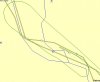
  • Altitude Mode: Extruded <--- this will give you the wall!
Click the "Create KML file" button. Once it is done, it will give you a link to the file, which you can click on. Do a "right click - save as" to save the KML (.kmz) file to your computer. Open up in Google Earth and fly around.

You can share the KML file or take JPEG snapshots once in Google Earth.

I use a Garmin Etrex Vista C for data logging. I just chuck in the back of the plane clipped onto my flight bag. It is WAAS enabled with a built in barometric altimeter.
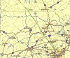
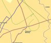
Sample: http://jimcullum.googlepages.com/10-May-08-solo2keul.jpg

Great fun/educational especially for the student. Can't cheat on those turns around the point when you have the GPS logging your "circles".

Have fun.

Jim.
 
Cool,.. thanks guys. I have to get time to play with this. I just got the Airmap used, and it has software that I still have to install.

Edit,.... Here's our track from MapCreate,.. and I now have a text file to use,.. we'll see if I can get to Google Earth now...

Here's my overall from Bob and I flying to 7N1 last Wednesday. Then, there is a closeup of each airport. At LOM, you can see our departure with the slow right turn to the north and even all our ground time from the tiedown spot. Then, coming in from the top and overflying the field, with a nice right turn to enter the downwind over the quarry. That was at night when I turned off the GPS. At Painted Post (7N1) we overflew the airport and ended up flying that long 180* turn in the upper right, making a left through it, to enter the downwind for 32. We taxied to parking. Later, we taxied from parking to the tanks, filled, and then to the far left of the runway to depart RY 14.

Now,.. I have this in MapCreate, but can't seem to get it out of MapCreate into a text file that is readable by the website above.... ? I"m going to try downloading and installing EasyGPS next, looks like that will work.
 

Attachments

  • Overall Track.JPG
    Overall Track.JPG
    216.5 KB · Views: 29
  • LOM.JPG
    LOM.JPG
    65.8 KB · Views: 20
  • 7N1.JPG
    7N1.JPG
    60.6 KB · Views: 22
Last edited:
Once you get it setup to see your GPS,

How do you connect the GPS to the computer? Do you need a serial cable?

I have the Lowrance Airmap 2000C and I'd need to power it as well as breaking out the communication lines. I have a factory cable that ends in pigtails that I used to interface the GPS to my fuel monitor. Do you modify one of those cables?

Thanks

Paul
N1431A
KSDM

The serial cable option may work, but you would have to solder on a DB-9 connector to the bare end of your cable. Probably not worth trying.

After looking at the manual and the EasyGPS help, here is an easier option. Just let Easy GPS read the files off of the memory card in your 2000C. Pull the card out and put it in a memory card reader of your computer.


To get EasyGPS to see the files on the memory card:
  • Run EasyGPS after installing from easygps.com
  • click on Edit then Preferences.
  • Click "Add GPS"
  • Choose Lowrance - 2000C
  • Choose "memory card"
  • It should then connect to your memory card and you can "receive" from the card as in my example above.
More info: http://www.easygps.com/gps_receivers/Lowrance_AirMap_2000C.asp

Good luck.

Jim.
 
Followed what you posted above by loading EasyGPS on my computer and linked it to the Airmap 500 via memory card. I opened the .usr file into EasyGPS and it pulled up my waypoints when I was messing around with the unit as well as our track from Wed. Saved as a GPX file, and used the GPSVisualizer link to create the kmz file.

Wow! So Cool. I guess my .usr file from my track doesn't save altitudes, but this is still very cool.

Open this file in Google Earth to see our flight! :D
 

Attachments

  • 1226965202-13984-96.227.239.106.kmz
    3.7 KB · Views: 11
Last edited:
I've used Motion-Based a few times and like the "playback" feature. I'm sure there are many good ones in this day and age that'll have everything you're looking for.
 
Wow! So Cool. I guess my .usr file from my track doesn't save altitudes, but this is still very cool.

There has to be a way for our altitude to show up. I am going to try another "track" when I take the plane to Elkton for annual this week.
 
Motion Based does show altitude. That's the tool I used in a earlier post to show the trip down the river.
 
Currently, I see that the trail function stores the latitude and longitude of the gps. While we can see Groundspeed and Altitude on the GPS while in use, unless I have a setting turned off somewhere, it seems like the file saved to the data card (.usr file) contains any saved waypoints, trails, or points of interest.

I'll boot up my other computer and see when I get a chance. Our laptop has Vista,.. Yuk! So I run all my stuff off the older desktop.

Oh,.. you can click on my blog and then see the Google Maps Link there if you don't want to open the file in Google earth.
 
Last edited:
Thanks guys for posting this thread. I downloaded Easy GPS and figured out how to get the stuff out of my Lowrance 2000C GPS and onto Google Earth-----.

I gotta be careful who I show that stuff to. It shows every squiggle I made. On recent flight from Tacoma Wa to San Diego I circled trying to find an airport that was right underneath me. I had no idea I circled THAT many times:blush:.

If you bust the Class B-----there it would be--- solid evidence against you.

What surprised me was that the data was not originally on the SD card in the GPS, but held in the non-volatile memory. I had to download it from the GPS to the CARD then extract it. I wish Lowrance had a better manual for their product.

Cheers:

Paul
N1431A
KSDM
 
Rob--FWIW I have an Airmap 500 as well. Nice GPS for the money--I noticed that it doesn't save the altitude in the .usr file either. I never did figure out a way to get it to save the altitude.
 
Back
Top