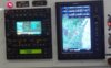
Something like a Garmin 430W:
1) Will be built from mil/aerospace spec components and be much less susceptible to environmental effects. It's not going to suddenly shut off because it got too hot.
2) Will be hard-wired to the airplane's electrical system, with both battery and alternator power available. No battery dying with no warning because the 12V plug worked its way out of the socket thanks to three hours of vibrations...
3) Will be connected to a CDI (or HSI) right in the pilot's scan that will quickly show how close to the course you are regardless of zoom level.
4) Can detect if any of the GPS satellites are sending slightly erroneous information and ensure the integrity of its position calculation via
RAIM.
5) Has had its software extensively quality-checked using methods not normally used in consumer electronics.
6) Calculates its position more often (430W is 5Hz, iPad is 1Hz for example)
7) Is overall going to be much more reliable and much better tested to ensure safety.
That said, they're different tools. A panel-mount IFR GPS is what you use to actually navigate the airplane. An EFB like an iPad with ForeFlight is used for flight planning, situational awareness and electronic charts. Neither is sufficient for all your needs for IFR on its own, but they're for different things.
") .
.