GPS LPV Mins lower than ILS

HPNPilot1200

En-Route
Joined
Jul 6, 2005
Messages
2,662
Location
Huntington Beach, CA
Display Name
Jason
Home Airfield
KSNA
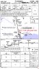
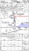
Here is an interesting example at my home airport where the GPS approach now has lower mins than the ILS. The ILS was also recently revised as it used to require 250-1. Now it is 279-7/8, increasing the DA by 29 feet and decreasing the visibility by 1/8 mile.

The TDZE is also now charted 35 feet lower than in the last chart cycle which is rather significant. The ILS DA at OXC has been 971 ft for many many years. Now the DA reference to TDZE is higher but the DA in ft MSL is lower. :mad2:

This is the first revision where the GPS Rwy 36 has LPV and LNAV/VNAV (WAAS) minimums. I am just starting to read the Form 8260-3 reference to the ILS 36.

attachment.php


attachment.php
 

Attachments

  • gps36.jpg
    gps36.jpg
    251.7 KB · Views: 222
  • ils36.jpg
    ils36.jpg
    260.9 KB · Views: 220
Last edited:
I dug a little deeper and went through FAA form 8260 for the ILS or LOC 36 OXC amendment 14.

The change in DA from 971/250 to 965/279 occurred with the following reasoning "MINIMUM ALLOWED DUE TO GLIDESLOPE UNUSABLE BELOW 965 MSL RESTRICTION; HATH BASED ON THLD ELEV."

I have not found any mention in the document about the change in TDZE for RWY 36 but it is noted as 686 feet. It appears as if the reduction in TDZE from 721' to 686' would have brought the DA down to 936' but since the glideslope is unusable below 965' that became the new DA. Since the GPS 36 approach to LPV minimums utilizes a WAAS-generated glide path, the glideslope restriction is not applicable on that procedure.

The visibility change from 1mi to 7/8 mi occurred due to TERPS criteria for minimum visibility values to runways with no approach light system with a HATh range between 261' and 280'. (8260.3B CHG 20, CH3. pg. 3-21).
 
Jason I have to look in my logbook. This was the situation at ONE of the airports I was recently at...250 vs ?280 as well. I was a tad surprised.
 
Jason I have to look in my logbook. This was the situation at ONE of the airports I was recently at...250 vs ?280 as well. I was a tad surprised.

IIRC it is the OCS difference for the visual segment of the approach.
 
I dug a little deeper and went through FAA form 8260 for the ILS or LOC 36 OXC amendment 14.

The change in DA from 971/250 to 965/279 occurred with the following reasoning "MINIMUM ALLOWED DUE TO GLIDESLOPE UNUSABLE BELOW 965 MSL RESTRICTION; HATH BASED ON THLD ELEV."

I have not found any mention in the document about the change in TDZE for RWY 36 but it is noted as 686 feet. It appears as if the reduction in TDZE from 721' to 686' would have brought the DA down to 936' but since the glideslope is unusable below 965' that became the new DA. Since the GPS 36 approach to LPV minimums utilizes a WAAS-generated glide path, the glideslope restriction is not applicable on that procedure.

The visibility change from 1mi to 7/8 mi occurred due to TERPS criteria for minimum visibility values to runways with no approach light system with a HATh range between 261' and 280'. (8260.3B CHG 20, CH3. pg. 3-21).

Where did you get that? From the coordination website?
 
Yup. Here is the link.

I've got the link :), just wasn't sure if the FAA opened up the resources to their website yet. Once the coordination period is complete you can't get the 8260 forms unless you have the inside scoop. I still don't know exactly how to get the forms, but several on the CHIPs committee get them to review approaches.

Bob
 
Jason has found an approach where the LPV minimums are less than the ils minimums. Here, the reason seems to be because the glideslope has been found to be not usuable below a certain altitude, an unusual circumstance.

Other than for a similar reason, are there any approaches out there where LPV minimums are below ils minimums?

We recently got an LPV approach at my airport (KIPT - LPV 30) and its minimums are lower than the ILS 27. I believe the reason for that is related to the missed approach procedure. Runway 27 points you precariously close to a large immovable object (ridge). Runway 30 points you 30 degrees away from that ridge.

But, I'm not Flight Check, so you'd have to ask them for certain. That's what the locals all tell me the reason is, and it makes sense.
 
One of the criteria for setting minimums has to do with the obstruction survey the FAA has on file. They have been doing a lot of surveys for LPV approaches lately. Typically they'll look at all of the approaches and see what revisions can be made to existing approaches, but sometimes there are ILS issues that don't apply to the LPV, as in the "glideslope unusable below ..." example above. Other times they'll design the new approach using the new survey data, but can't revise the ILS right away because they can't schedule a flight check or whatever.

They are also starting to insert notes for certain approaches not being available at night if the PAPI is inop. That has cropped up a number of times. I'm told it's a policy change.
 
Jason has found an approach where the LPV minimums are less than the ils minimums. Here, the reason seems to be because the glideslope has been found to be not usuable below a certain altitude, an unusual circumstance.

Other than for a similar reason, are there any approaches out there where LPV minimums are below ils minimums?

The missed approach procedures really affect the MDA at some places. Since you can put GPS waypoints anywhere, but the VOR's generally work best up on top of hills and they're almost always used for missed approaches. So if the missed approach for the ILS expects you to be able to climb to not fly into the hill, it might not let you go down as far as the LPV approach that turns you away to a waypoint that might be well away from anything high up, so the approach allows you to go a lot lower...

I think I remember this being one of the quizzes in IFR magazine.
 
Back
Top