zaitcev
En-Route
- Joined
- Sep 30, 2010
- Messages
- 3,257
- Display Name
Display name:
Pete Zaitcev
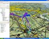
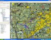
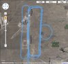
Here's my recent flight overlaid on Google Maps. BTW, the accidentially narrow right pattern resulted in a go-around as I got too high. The tower didn't give me another right pattern afterward, maybe I should have requested it. The point here is though, without GPS or instructor onboard I did not realize that my right pattern was defective and that it probably was what caused me getting high, so GPS can be useful in this regard.
Attachments
Last edited: