alaskaflyer
Final Approach
- Joined
- Feb 18, 2006
- Messages
- 7,544
- Location
- Smith Valley, Nevada
- Display Name
Display name:
Alaskaflyer
So a while ago on the defunct forum "which shall remain nameless" we had a thread which I found both fascinating and fun. I'd like to see everyone's home airport via Google Earth (or Microsoft Terraserver if you are a clone  )
)
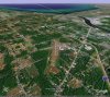
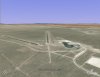
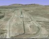
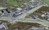
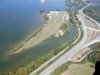
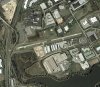
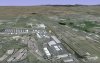
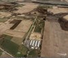
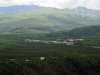
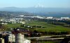
Here's mine, along with a fly-to placemark to take you there if you have GE installed, click on the .kmz file attached. Unfortunately photo quality in my part of Alaska leaves something to be desired, but you get the idea. Mt. McKinley is in the distance at the top.

If you don't have GE you should, it's free! http://earth.google.com/
)Here's mine, along with a fly-to placemark to take you there if you have GE installed, click on the .kmz file attached. Unfortunately photo quality in my part of Alaska leaves something to be desired, but you get the idea. Mt. McKinley is in the distance at the top.
If you don't have GE you should, it's free! http://earth.google.com/
Attachments
Last edited: